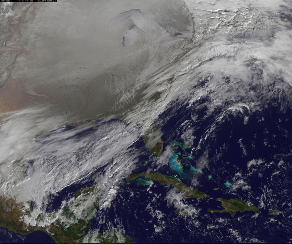
Swirling 'Polar Vortex' Over Northern US Seen From Space

A whirling onslaught of frigid air, known as a polar vortex, moves menacingly over the northern United States in a new photo from a weather satellite in orbit.
The National Oceanic and Atmospheric Administration's GOES-East satellite snapped the telling photo today (Jan. 6) at 11:01 a.m. EST (1601 GMT). In the image, the polar vortex is pushing southward over western Wisconsin and eastern Minnesota, blasting half of the continental United States with chilly Arctic air.
The polar vortex is a sprawling area of low pressure typically found over both the North and South poles, according to NASA. The northern polar vortex typically circulates from west to east in the Arctic during winter, but a high-pressure system parked over Greenland and Canada has pushed the cold air into the United States. This is causing air temperatures to drop across the northern U.S., and the Arctic air is being felt as far south as Atlanta.
Yesterday, the swirling polar vortex caused a staggering temperature difference of 140 degrees Fahrenheit (77 degrees Celsius) across the country, from North Dakota to Florida. The polar vortex is expected to move northward back over Canada near the end of the week, NASA officials said in a statement.
The GOES-East satellite also captured a frontal system along the U.S. East Coast. Additionally, a blanket of snow can be seen covering Minnesota, Wisconsin, Illinois, Indiana, Ohio, Michigan, Iowa and Missouri, with patches spreading into the Great Plains.
The clouds visible over Texas are part of a low-pressure system currently sitting over western Oklahoma, which is tied to the cold front triggered by the movement of the polar vortex, according to NASA officials.
The northern and southern polar vortexes develop and strengthen in their respective hemispheres' winters, as the sun sets over the poles and temperatures cool. The Arctic polar vortex has already moved southward several times this winter, NASA officials said.
Get the Space.com Newsletter
Breaking space news, the latest updates on rocket launches, skywatching events and more!
The satellite photo was created as part of NASA's GOES Project, which is located at the Goddard Space Flight Center in Greenbelt, Md.
Follow Denise Chow on Twitter @denisechow. Follow LiveScience @livescience, Facebook & Google+. Original article on LiveScience.
Join our Space Forums to keep talking space on the latest missions, night sky and more! And if you have a news tip, correction or comment, let us know at: community@space.com.

Denise Chow is a former Space.com staff writer who then worked as assistant managing editor at Live Science before moving to NBC News as a science reporter, where she focuses on general science and climate change. She spent two years with Space.com, writing about rocket launches and covering NASA's final three space shuttle missions, before joining the Live Science team in 2013. A Canadian transplant, Denise has a bachelor's degree from the University of Toronto, and a master's degree in journalism from New York University. At NBC News, Denise covers general science and climate change.
