How to Use Mobile Apps to Spot the Space Station and Iridium Flares
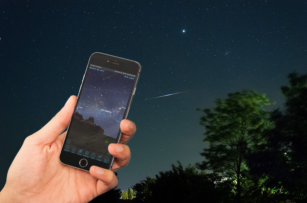
The night sky is a busy place! Whether you are a casual skywatcher out walking the dog or sitting on the dock, or an astronomer at the eyepiece, you're almost guaranteed to see an artificial satellite passing overhead or zipping through your field of view.
In this edition of Mobile Astronomy, we'll look at the apps for identifying satellites, predicting these satellites' passes, seeing spectacular Iridium flares, and even riding along with the International Space Station!
First up, we'll look at why we can spot satellites and explain some of the names you'll encounter when you work with satellite-spotting mobile apps. Then, we'll look at a sampling of the better apps, as well as which features to look out for.
Related: Spot the International Space Station Location with New NASA Tool
What's that light?
Since the first artificial satellite, the Soviet Union's Sputnik 1, kicked off the space age on Oct. 4, 1957, more than 7,000 objects have been launched into orbit. Many of these were satellites for scientific, telecommunication and military uses, while the rest consisted of spent rocket boosters and other space debris. The largest object by far is the International Space Station (ISS). This 462-ton (419 metric tons) crewed orbiting space laboratory is about the size of a football field (including the end zones) and includes an acre of solar panels! At the other end of the scale are tiny cubesats measuring only 4 inches (10 centimeters) on each side.
Orbiting satellites can be spotted because they are high enough overhead to be illuminated by sunlight, even when the sun is below the horizon for ground observers. Except for the time when they pass through the Earth's circular shadow, they are fully lit. Low orbit satellites can only catch the sun's rays in the hours just after sunset and just before sunrise. For satellites that are in extremely distant orbits, the Earth's shadow covers only a small patch of the sky, so they can be spotted in the middle of the night, too.
The brightness of the satellite depends on its distance and how much sunlight it reflects, by surface area and/or reflectivity. Most satellites exhibit a steady light, but objects that are tumbling can glow and darken as they move. Other than crewed vehicles, satellites do not have lights, and none would be bright enough to spot from Earth anyway. If you see an object with flashing lights, it's an aircraft.
Get the Space.com Newsletter
Breaking space news, the latest updates on rocket launches, skywatching events and more!
Telecommunication and some surveillance satellites have geosynchronous orbits designed to keep the spacecraft in view from the same spot on Earth at all times. To do this, they need to be placed at 22,236 miles (35,786 km) above sea level. This type of satellite will be dim and may be captured in your telescope, moving very slowly against the background stars. They stay in the same patch of the sky, more or less over the equator, so you can aim your satellite dish at them.
Spacecraft that need to move around the Earth at a modest rate are placed closer in, at 12,600 miles (20,200 km) above sea level. This includes the 31 Global Positioning System (GPS) satellites, and the satellites in the navigation networks of Russia (GLONASS), Europe (Galileo), China (BeiDou), India (IRNSS) and Japan (QZSS). These satellites pass over the same spot on Earth every 12 hours and are not observable to the naked eye.
Satellites that need to closely observe Earth's surface and weather, or that are too heavy to lift into high orbits, are placed in low Earth orbit (LEO). These are the bright satellites you'll see zipping across the night sky. Low earth orbits fall into a range. To minimize drag on spacecraft from the upper atmosphere and allow for high-resolution close-up views of Earth, 190 miles (300 km) is the lower limit. The upper limit is about 1,250 miles (2,000 km), just inside the protective shell of the Van Allen radiation belts.
Satellites in LEO need to move fast, taking between 90 and 225 minutes to complete one orbit of Earth. Well-known examples include the ISS, the Hubble Space Telescope, China's Tiangong 1 space station, National Oceanic Atmospheric Administration weather satellites, Landsat (used for Google Maps), Iridium satellites and Europe's Envisat. The American Atlas-Centaur and Russian COSMOS (sometimes spelled Kosmos) and Breeze (sometimes spelled Briz) expended rocket upper stages also fall into this class.
Spotting the ISS
The ISS was assembled by launching individual modules and connecting them together in orbit. The first component, dubbed Zarya (which means "sunrise" in Russian), was launched on a Russian rocket on Nov. 20, 1998, so nearly all satellite apps refer to the ISS as Zarya. The station's solar panel arrays rotate constantly to keep them aimed toward the sun, and reflections from them produce the steady glow as it flies overhead.
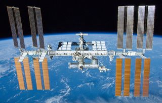
The ISS has a low Earth orbit only 214 miles (343 km) high, so it is one of the objects that completes one orbit of the Earth every 90 minutes (16 per day). When the ISS returns to its starting point, the Earth has rotated to the east by 22.5 degrees. By tilting the orbit with respect to the Earth's equator, a series of diagonal strips are covered, with each strip shifted west of the previous one. That way, almost all of Earth's surface will be flown over every few days.
The ISS' orbit is inclined 51.6 degrees from the equator, so it only travels between 51.6 degrees north and 51.6 degrees south latitude (roughly the Kamchatka Peninsula to the Falkland Islands). While it passes over the same spot on Earth every three days, the time when it does so drifts, so it actually takes 63 days for the space station to appear over your house at the same time of night. The station need not be straight overhead to see it, though. At that height, one or two passes east and west of your location should allow it to be visible, too, if conditions are right.
ISS-tracking apps know the orbital details and work out the geometry of the sun's position, and your location, to predict sightings for you. Higher passes are always brighter and longer — up to 5 minutes from horizon to horizon, often passing nearly overhead. For passes east or west of your location, the station will climb to a maximum angle well below the zenith (highest point in the sky) and may be visible for only a minute or less. The app will indicate the maximum height above the horizon in degrees, the direction of motion and the duration. Most apps offer an icon to distinguish a high-quality pass from a mediocre one. The better apps allow you to filter out the poor sightings.
Iridium flares
Iridium Communications owns and operates a network of satellites employed for worldwide pager and satellite phone communications. There are about 72 of these satellites circling the globe in a pole-to-pole low Earth orbit. They are equipped with three very reflective, polished, door-size antennas that reflect a brilliant beam of sunlight onto a track along the ground. If you are located on one of the tracks when the sun is in the right position, you will see a flash of light lasting 5 to 7 seconds. Known as Iridium flares, they often outshine all of the brightest stars and planets, and they're a treat even for seasoned skywatchers!
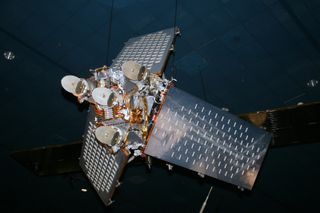
With the help of a satellite app that predicts Iridium flares, you can know when to watch and where to look — a great way to impress your friends! Timing is very critical for these, so modern smartphones and tablets, with their accurate GPS clocks, are ideal. All of the better apps use your device's orientation sensors and display to point you to the right patch of the sky, and feature programmable alerts and audible countdowns. Next, I'll describe some good ones.

Satellite spotting on your mobile device
Many of the better sky-charting apps include major satellites and an option to display them against the sky. SkySafari 5, Star Walk 2, Sky Guide, Night Sky, Star Chart, Stellarium and others have an extensive catalog of satellites, indexed by category. Some of these apps use your device's compass and gyroscope to show the sky as you move your device around, and selecting a satellite brings up an arrow that indicates the direction in which you need to move to center it.
Be sure to select an app that automatically updates the satellites' orbital data from time to time so you won't need a live Internet connection when outside. Most of the apps mentioned above offer predictions of when you can go outside to view bright satellites. SkySafari 5, Star Walk 2and Sky Guide will also send you an alert on your mobile device (or smartwatch) to warn you a few minutes ahead of time.
Dedicated satellite-tracking apps are widely available in the Apple App Store and the Google Play store. The ISS Spotter and ISS Locator apps for iOS are both fairly basic. At launch, a prediction button presents the passes occurring over the next several days, ranked with a symbol to indicate quality (height, brightness, etc.). Clicking on the pass brings up a simple graphical indicator of the height and direction.
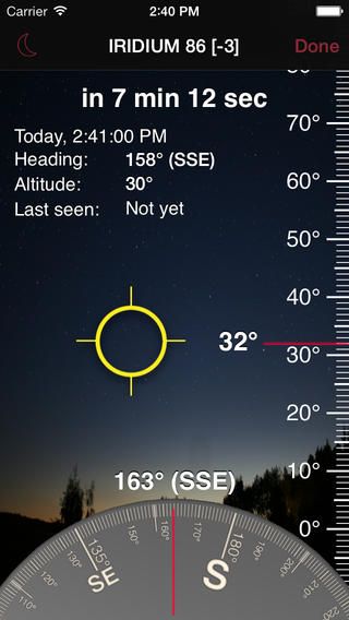
The best dedicated apps are those that use your device's compass and gyroscope in real time to guide you where to look, especially for Iridium flares. The iFlares app for iOS displays a compass and elevation scale on screen, as well as cursors that guide you to orient the device in the direction in which the flash will occur. Remember to get oriented ahead of time, so you're not looking at the device instead of the sky during those critical seconds!
The Satellite Safari app for iOS and Android does everything you'll need a satellite-tracking app to do. It features an extensive list of satellites, updated automatically, and the means to search for them individually. When you are exploring the satellite index, it highlights those with upcoming passes. Once the pass is selected, you can request to preview the event against a realistic sky and set an alert. In compass mode, the device will steer you toward the satellite. Each satellite and its path can be shown against your sky, or be displayed on a rotatable globe or as a track along the Earth. And the app's powerful user interface offers time flow controls, compass mode and night vision.
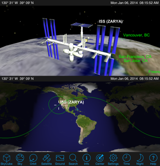
The free GoISSWatch app (ISS only) and the paid GoSatWatch app for iOS feature pass predictions and the ability to display the satellite track on a globe or map, and against your night-sky star field in pan, pinch and zoom modes, as well as in dynamic compass mode. Time flow is available to preview the pass.
The ISS Detector app for Android by RunaR comes in a free version that includes tracking of the ISS and Iridium flares, as well as an option to purchase a suite of additional satellites, planets and comets. The app's user interface is very easy to interpret. The Upcoming Pass page distinguishes Iridium flares, satellites and other objects' labels with unique colors. For each pass, an easy-to-interpret "eye" icon is sized to represent the quality of the pass, the local time of the Iridium flare, or start and end of the satellite pass, as well as the angle above the horizon at which it will occur. The app links to your local weather forecast, grades the probability of the pass quality and shows the weather as a symbol. Even the sunrise and sunset times are available at a glance. If you are only interested in certain types of events, filters can be applied to the Events page, and alerts can be enabled for only the types of events you want. Within each object category, you can set limits on the minimum elevation (if your horizon is obstructed) and the minimum brightness; toggle all-day or night-only passes; and even set the quality threshold. You can manually refresh the orbital data anytime, and the time until the next event is prominently indicated. You can even share the events on social media.
On the phone version of ISS Detector, selecting an event brings up a pair of panels named Radar and Details. They're already there on a larger tablet display. The Details pane shows the satellite events' numerical parameters, including the current satellite location on Earth and in the sky. Accompanying this is a map of the Earth showing the orbit track and location. A double tap enlarges the map for pan, pinch and zoom exploring, and a tap on the Return button reverts to the data/map format.
The Radar pane is extremely handy. It presents a dynamic compass and tilt indicator to allow you to align your device with the satellite. For Iridium flares, a dashed arc on the compass indicates the satellite path, and a dot indicates the flare location. For satellite passes, a solid blue arc indicates the track and the point of maximum height. During a live event, the compass needle follows the satellite. In both cases, the moon and the planets are displayed to help orient you, and a tap toggles labels on and off. A single tap toggles from compass mode to a whole sky star map with the object track and direction nicely indicated.
The free app Sputnik! for iOS provides predictions for the ISS and Iridium flares, and offers nearly everything you need for a successful sighting in a simple way. Like the others, the app uses your default location, or you can enter a different one, in case you're going camping. Once an event is selected, details about the time, direction, height and brightness are provided. But the best feature appears when you rotate the device to landscape mode. A simple graphical representation of the sky appears, complete with satellite track and direction against a correct star field (including the moon and visible planets), and a circle where the flare will occur. For the ISS, both the visible and nonvisible portions of the track are shown, with the transition point indicated by a circle. You can add the event to your device's calendar and note-taking utility. As with many apps, there is an option to issue an alert a short time before the sighting and then an audible second-by-second countdown. You can even share your success on social media!
Another great Sputnik! feature is offline usage. The system clock is calibrated, and satellite ephemera downloaded, when an Internet connection is available, but the app works perfectly well in remote locations. There is a device orientation button that uses your device's gyroscope to indicate when it is tilted at the correct height toward the satellite. It even provides the sightings for the past 48 hours, in case a friend saw something and asks you to check. The free app has some ads, but I didn't find them to be intrusive.
Going beyond
While many free apps allow you to track the ISS and Iridium flares, most of them will allow you to pay a small fee to add other bright satellites, including the Hubble Space Telescope, China's Tiangong 1 space station and the bright Russian Kosmos satellites.
The ISS onLive app for Android and ISSLive for iOS, both free from NASA, let you explore the space station in great detail. ISS onLive lets you track the space station in real time on a map of the Earth, set alerts for upcoming passes in your area, and select from three video streams - two from cameras mounted outside the station, and NASA TV. Watch out for data charges as these are live streams! ISSLive offers 3D renderings of the station and mission control, current and upcoming science and crew activities on the station, and much more. It’s a must for human spaceflight enthusiasts!
The free Earthlapse app for iOS provides recorded loops of some of the best earth views from the space station, all set to eight soothing soundtracks. Options include adding an on-screen clock and your local weather, making a nice live wallpaper, and the ability to send the display to your TV or other AirPlay device. And the stored recordings won’t consume your data bandwidth.
In the next mobile astronomy column, we'll "See Stars in Color" — looking at the star temperature-color relationship and a sky tour of some visually colorful stars you can hunt down using your astronomy app and observe by eye, binoculars or telescope. Have you heard of Capella, Arcturus, Sirius or Betelgeuse? I'll tell you all about them. Until next time, keep looking up!
Chris Vaughan is an astronomy public outreach and education specialist, and operator of the historic 1.88 meter David Dunlap Observatory telescope. You can reach Chris Vaughan via email, and follow him on Twitter @astrogeoguy, as well as Facebook and Tumblr.
This article was provided by Simulation Curriculum, the leader in space science curriculum solutions and the makers of the SkySafari app for Android and iOS. Follow SkySafari on Twitter @SkySafariAstro. Follow us @Spacedotcom, Facebook and Google+. Original article on Space.com.
Join our Space Forums to keep talking space on the latest missions, night sky and more! And if you have a news tip, correction or comment, let us know at: community@space.com.
Chris Vaughan, aka @astrogeoguy, is an award-winning astronomer and Earth scientist with Astrogeo.ca, based near Toronto, Canada. He is a member of the Royal Astronomical Society of Canada and hosts their Insider's Guide to the Galaxy webcasts on YouTube. An avid visual astronomer, Chris operates the historic 74˝ telescope at the David Dunlap Observatory. He frequently organizes local star parties and solar astronomy sessions, and regularly delivers presentations about astronomy and Earth and planetary science, to students and the public in his Digital Starlab portable planetarium. His weekly Astronomy Skylights blog at www.AstroGeo.ca is enjoyed by readers worldwide. He is a regular contributor to SkyNews magazine, writes the monthly Night Sky Calendar for Space.com in cooperation with Simulation Curriculum, the creators of Starry Night and SkySafari, and content for several popular astronomy apps. His book "110 Things to See with a Telescope", was released in 2021.

