Rina, Denver Snowstorm Caught in Same Satellite View
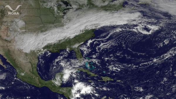
While passing over the United States today (Oct. 27), the GOES East satellite snapped this picture of North and Central America in which Tropical Storm Rina and the snow that blanketed Denver are clearly visible.
While Rina looked poised to become a major hurricane (a Category 3 or higher) earlier this week, the storm has since weakened considerably and has been reduced to tropical storm status. Forecasters still warn that the storm could bring impacts for places along the Yucatan Peninsula.
Another storm, this one of the wintry variety, rushed through Denver yesterday, dumping up to 18 inches (46 centimeters) of wet, heavy snow that knocked out power to thousands in the area. The October snowstorm came just a day after the city saw record high of 80 degrees Fahrenheit.
The continuation of that system can be seen bringing rain and cooler temperatures to the East Coast, and the possibility for some light snow in West Virginia into Friday.
This article was provided by OurAmazingPlanet, a sister site of SPACE.com.
Get the Space.com Newsletter
Breaking space news, the latest updates on rocket launches, skywatching events and more!
Join our Space Forums to keep talking space on the latest missions, night sky and more! And if you have a news tip, correction or comment, let us know at: community@space.com.
For the science geek in everyone, Live Science breaks down the stories behind the most interesting news and photos on the Internet, while also digging up fascinating discoveries that hit on a broad range of fields, from dinosaurs and archaeology to wacky physics and astronomy to health and human behavior. If you want to learn something interesting every day, Live Science is the place for you.


