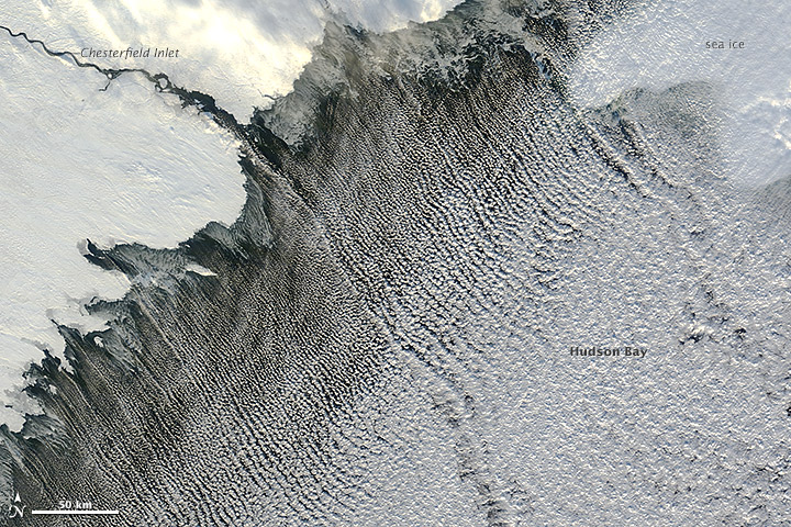
Striking 'Cloud Streets' Seen From Space

Trapped beneath a warm air layer and directed by a cold northwesterly wind, fluffy cumulus clouds line up in bands called 'cloud streets' in an image captured Nov. 13 by NASA's Terra satellite.
The visible light image by the satellite's Moderate Resolution Imaging Spectroradiometer (MODIS) shows skinny, northwest-oriented clouds filling Hudson Bay in northeastern Canada.
Cloud streets — long parallel bands of cumulus clouds — form when cold air blows over warmer waters, while warmer air called an inversion layer rests on top of both, according to NASA's Earth Observatory.
When heat and moisture from the comparatively warm water rise through the cold air above, the rising thermals hit the inversion layer, which acts like a lid. The thermals roll over and loop back on themselves, creating parallel cylinders of rotating air. As this happens, the moisture in the warm air cools and condenses into flat-bottomed, fluffy-topped cumulus clouds that line up parallel to the prevailing wind.
This story was provided by OurAmazingPlanet, sister site to SPACE.com. Follow OurAmazingPlanet on Twitter @OAPlanet. We're also on Facebook and Google+.
Get the Space.com Newsletter
Breaking space news, the latest updates on rocket launches, skywatching events and more!
Join our Space Forums to keep talking space on the latest missions, night sky and more! And if you have a news tip, correction or comment, let us know at: community@space.com.
OurAmazingPlanet was founded in 2010 by TechMediaNetwork, which owned Space.com at the time. OurAmazingPlanet was dedicated to celebrating Earth and the mysteries still to be answered in its ecosystems, from the top of the world to the bottom of the sea. The website published stories until 2017, and was incorporated into LiveScience's Earth section.

