Britain Blanketed by Snow in New Satellite Image

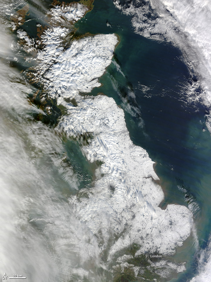
Unusually frigid and snowy conditions blanketed much of the island of Great Britain in snow earlier this month. The winter wonderland was spotted from above by NASA's Terra satellite on Jan. 26.
The snow started falling mid-month when a storm system blowing in from over the North Atlantic combined with unusually chilly conditions ushered in by a pattern called the Scandinavian Block, according to Accuweather.com. This high-pressure pattern sits in place over Scandinavia and funnels cold air toward the United Kingdom from over the Baltic and western Russia, according to the U.K. Met Office.
As of the afternoon of Jan. 21, Redesdale Camp, Scotland, was the nation's leader in snowfall, with 11 inches (29 centimeters), Accuweather reported. Earlier Accuweather reports said 8 inches (20 cm) had fallen in Sennybridge, Wales, and 6 inches (15 cm) in Dunkeswell, in the southwest of England. The snows closed many schools and forced flight cancellations and delays at London's Heathrow Airport.
Snow is a relatively uncommon sight, particularly in the southern parts of Great Britain, as the flow of the Gulf Stream funnels warm waters toward the islands, influencing the atmosphere and making conditions there milder than might be expected for the island's northerly latitudes.
Met Office records show that the U.K. sees about 33 snow days per year, based on 1971-2000 averages, though most of this falls on higher ground where temperatures are colder. And not all of that snow even settles on the ground, with the U.K. seeing only about 16.5 days a year of snow on the ground. Scotland, situated at higher latitudes, sees a higher average, with about 52 days of snow or sleet in a given year and 27.7 days of snow on the ground, the Met Office says. It lists the snowiest place in the U.K. is Banffshire, a county in the northeastern part of Scotland, which has a yearly average of 63.8 days of snow or sleet. (At the other extreme is Cornwall, which has an average of 10.2 days of snow or sleet.)
The snowiest winter of the 20th century for the U.K. was that of 1947, the Met Office says, when snow fell every day somewhere in the country between Jan. 22 and March 17.
Since the snows came earlier this month, temperatures have gotten milder and precipitation has fallen in the form of rain, at least in the southern parts of the island. Skies had largely cleared when the Moderate Resolution Imaging Spectroradiometer (MODIS) on the Terra satellite snapped its picture of Great Britain, the NASA Earth Observatory noted, though a few remained over the western part of the island.
Get the Space.com Newsletter
Breaking space news, the latest updates on rocket launches, skywatching events and more!
Southern parts of the island are currently threatened by flooding from heavy rains, with some higher elevations possibly seeing strong wind gusts, the Guardian reports.
This story was provied by OurAmazingPlanet, sister site to SPACE.com. Follow OurAmazingPlanet on Twitter @OAPlanet. We're also on Facebook and Google+.
Join our Space Forums to keep talking space on the latest missions, night sky and more! And if you have a news tip, correction or comment, let us know at: community@space.com.

Andrea Thompson is an associate editor at Scientific American, where she covers sustainability, energy and the environment. Prior to that, she was a senior writer covering climate science at Climate Central and a reporter and editor at Live Science, where she primarily covered Earth science and the environment. She holds a graduate degree in science health and environmental reporting from New York University, as well as a bachelor of science and and masters of science in atmospheric chemistry from the Georgia Institute of Technology.


