NASA Rover to Explore… Greenland

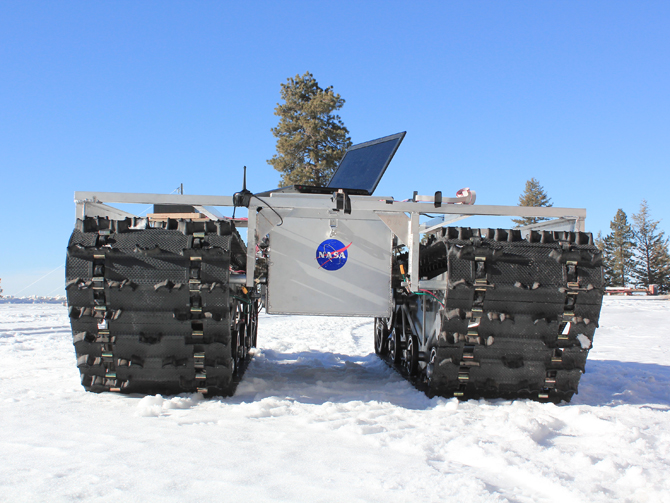
NASA's newest rover won't be exploring another planet, but will take a look at part of our own. Named Grover (short for Goddard Remotely Operated Vehicle for Exploration and Research), the rover will explore Greenland's ice sheets to better understand how they form, and how quickly they may be melting.
The device is solar-powered and semi-autonomous, and will embark on its first mission beginning tomorrow (May 3), and continuing until June 8. It was developed from 2010-2011 by teams of students in summer engineering boot camps at Goddard Space Flight Center in Maryland, according to a release from NASA.
The 6-foot-tall, 800-pound rover is equipped with ground-penetrating radar that will send "radio wave pulses into the ice sheet, and the waves bounce off buried features, informing researchers about the characteristics of the snow and ice layers," according to the NASA statement. [Video: Grover the Rover to Explore Greenland Ice Sheet]
At first Grover will operate near the National Science Foundation's Summit Camp, located at the apex of Greenland's ice sheet. Once it appears the rover is functioning properly, it will roam more widely and be controlled via satellite. Since the Arctic sun shines 24 hours a day during the summer, the solar-powered rover will be able to operate continuously, NASA said.
"We think it's really powerful," Gabriel Trisca, a Boise State master's degree student who developed Grover's software, said in the NASA statement. "The fact is the robot could be anywhere in the world and we'll be able to control it from anywhere."
Grover should shed light on Greenland's snow accumulation. Researchers can compare annual accumulation to the amount of ice lost to the sea each year to find out how much mass is being lost to melting, and how much Greenland's ice is contributing to sea level rise.
Greenland's ice sheets contain a vast store of freshwater that could affect global sea levels, and more and more ice is melting. In fact, Greenland's ice loss is accelerating by about 22 gigatons (22 cubic kilometers) of ice each year, according to a 2012 study.
Breaking space news, the latest updates on rocket launches, skywatching events and more!
Last summer, satellite images showed that about 40 percent of the ice sheet had thawed near the surface on July 8; only four days later, images showed a dramatic increase in melting with thawing across 97 percent of the ice sheet surface.
This story was provided by OurAmazingPlanet, a sister site to SPACE.com. Email Douglas Main or follow him @Douglas_Main. Follow us @OAPlanet, Facebook or Google+. Original article on LiveScience's OurAmazingPlanet.

Douglas Main loves the weird and wonderful world of science, digging into amazing Planet Earth discoveries and wacky animal findings (from marsupials mating themselves to death to zombie worms to tear-drinking butterflies). He is now a senior writer and editor for National Geographic, focusing on wildlife, nature and the environment.

