Amazing Ash Cloud Spied from Space Station
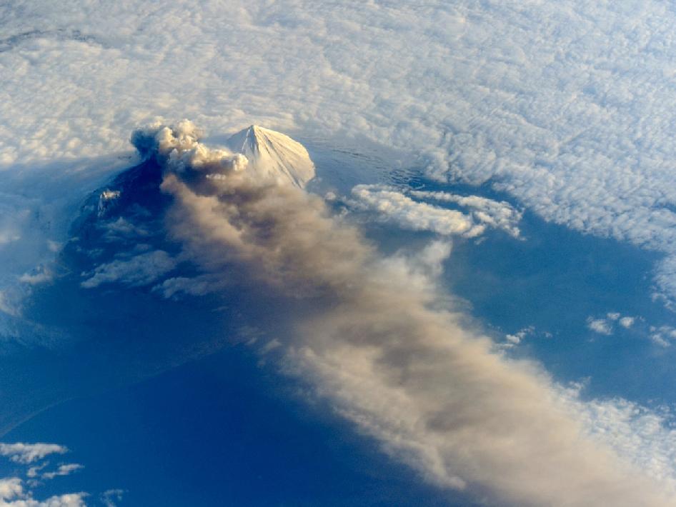
Clear skies and a passing space station combined for an extraordinary view of Alaska's erupting Pavlof volcano on May 18.
An astronaut aboard the International Space Station snapped a photo of ash streaming from the fiery peak in the Aleutian Islands, about 625 miles (1,000 kilometers) southwest of Anchorage.
Before Mount Pavlof started erupting on May 13, the volcano was as snowy white as its twin, Pavlof Sister, seen sitting directly northeast of the active volcano in the astronaut picture. The combination of melting ice and snow, volcanic gases and lava has sent pyroclastic flows racing down Pavlof's slopes, seen in earlier satellite images tracking the eruption. Pyroclastic flows are lethally hot, superfast flows of gas and rock fragments.
Satellites and earthquake monitors help scientists at the Alaska Volcano Observatory (AVO) track the ongoing eruption at Pavlof and the more than 30 active volcanoes in Alaska, many of which are far from towns, but can threaten planes with their ash. America's biggest state relies on small planes to ferry people and supplies to remote villages, and international cargo travels from Anchorage to Asia. When clouds hide the ash cloud, satellite heat imagery and seismic tremors help researchers confirm volcanoes such as Pavlof are still actively erupting. Local pilots also call in reports of ash and gas plumes to AVO scientists.
Pavlof's ash column has reached as high as 22,000 feet (7,000 meters), forcing regional airlines to occasionally delay or cancel flights to local villages and towns. Ashfall has been reported in nearby communities, including Sand Point, Nelson Lagoon, King Cove and Cold Bay, according to the AVO.
Scientists are also monitoring an ongoing eruption at Cleveland volcano farther to the west in the Aleutian Islands. With no seismic network at the remote site, scientists rely on satellites and infrasound — low-frequency sounds created below the range of human hearing — for eruption monitoring at Cleveland volcano.
This story was provided by LiveScience's OurAmazingPlanet, a sister site to SPACE.com. Email Becky Oskin or follow her @beckyoskin. Follow us @OAPlanet, Facebook & Google+. Original article on LiveScience's OurAmazingPlanet.
Get the Space.com Newsletter
Breaking space news, the latest updates on rocket launches, skywatching events and more!
Join our Space Forums to keep talking space on the latest missions, night sky and more! And if you have a news tip, correction or comment, let us know at: community@space.com.

Becky was a science reporter at The Pasadena Star-News. She has freelanced for New Scientist and the American Institute of Physics and interned at Discovery News. She earned a master's degree in geology from Caltech, a bachelor's degree from Washington State University, and a graduate certificate in science writing from the University of California, Santa Cruz. To find out what her latest project is, you can follow Becky on Twitter.


