Japan to Launch US Satellite to Map Earth's Rain & Snow Today: Watch It Live
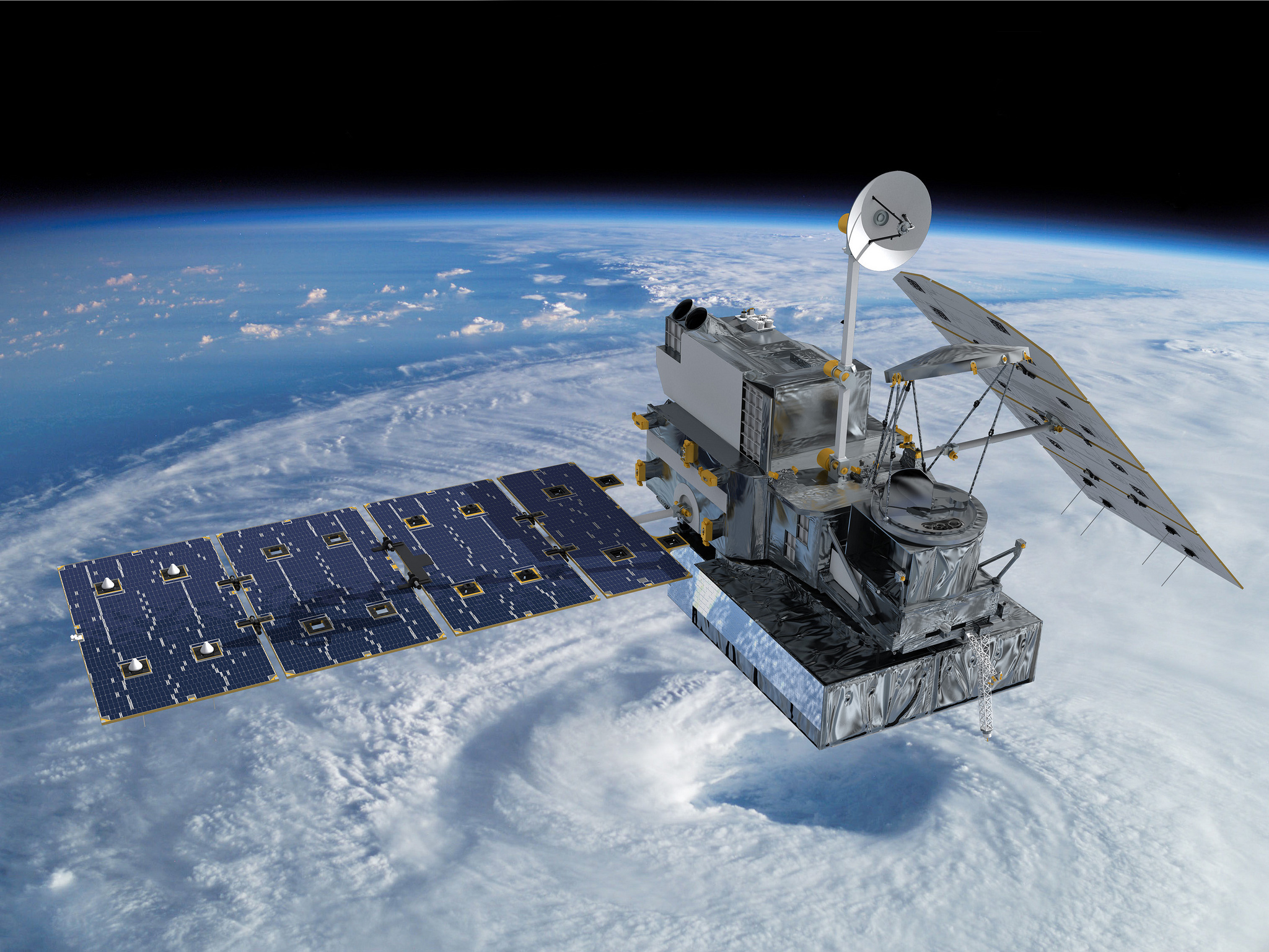
Japan is preparing to launch a U.S.-built satellite Thursday (Feb. 27) to track rainfall and snowfall over the bulk of the world's population, anchoring an international initiative to better understand Earth's water cycle and its relationship to storms, droughts and climate change.
The Global Precipitation Measurement Core Observatory is set for liftoff in a two-hour launch window opening at 1837 GMT (1:37 p.m. EST) aboard a Japanese H-2A rocket from the Tanegashima Space Center in southern Japan.
The launch window begins at 3:37 a.m. Japan Standard Time on Friday. You can watch the launch live on Spaceflight Now via the Mission Status Center. You can also watch the launch webcast live on Space.com, courtesy of NASA, beginning at 11:30 a.m. EST (1630 GMT).
The 174-foot-tall rocket will blast off from Launch Pad No. 1 at Yoshinobu Launch Complex, a facility on the rugged southeast coastline of Tanegashima Island off the southern shore of Japan's main island chain. [NASA's Rain-Watching GPM Satellite Mission in Pictures (Gallery)]
Flying southeast over the Pacific Ocean, the orange and black launcher will let go of two solid-fueled boosters about two minutes after liftoff. Six-and-a-half minutes into the mission, the rocket's hydrogen-fueled LE-7A main engine will turn off and the first stage will fall away, leaving the H-2A's second stage to propel the 8,500-pound satellite faster than five miles per second.
Deployment of the GPM spacecraft is expected less than 16 minutes after launch. Ten minutes later, the satellite's two solar array wings will unfurl to begin charging on-board batteries. [See the Launch Timeline from Spaceflight Now]
Two months of activation and commissioning tasks are planned before the satellite gets down to business.
Get the Space.com Newsletter
Breaking space news, the latest updates on rocket launches, skywatching events and more!

The GPM Core Observatory is the centerpiece of a worldwide program to synthesize observations from disparate international satellites into a database of global rainfall and snowfall every three hours.
"Why are we flying GPM? Rain and snowfall affect our daily lives in many ways," said Steve Neeck, NASA's deputy associate administrator for Earth science flight programs. "The distribution of precipitation ... directly affects the availability of fresh water for sustaining life. Extreme precipitation events like hurricanes, blizzards, floods, droughts and landslides have significant socio-economic impacts on our society." [Spaceflight Now Photos: H-2A Rocket Rolls Out with GPM Core Observatory]
Designed and built at NASA's Goddard Space Flight Center in Maryland, the GPM Core satellite weighs more than four tons fully fueled. It is about the size of a fire truck, and its solar panels deploy to a wingspan comparable to that of a small business jet, according to Art Azarbarzin, NASA's GPM project manager.
"Since rainfall and snowfall vary greatly from place to place and in space and time, satellites can provide a more uniform set for observations globally compared to ground instruments," Neeck said in a prelaunch press conference.
The GPM satellite hosts two instruments to peer inside storms and through cloud layers from an altitude of more than 250 miles.
![The GPM Core Observatory scans the weather with microwaves and two bands of radar. [See how the GPM Core Observatory Satellite works in this Space.com infographic]](https://cdn.mos.cms.futurecdn.net/L4AZuLJ9Gk5s7RnPMTxm8h.jpg)
One of the payloads, the Dual-frequency Precipitation Radar provided by the Japan Aerospace Exploration Agency, will scan the planet to acquire three-dimensional views of rain and snow showers.
NASA's GPM Microwave Imager, or GMI, built by Ball Aerospace and Technologies Corp. will measure the total precipitation suspended inside clouds and falling to Earth.
"The GMI will sense the total precipitation within all cloud layers, including, for the first time, light rain and snowfall," Neeck said. "The DPR will make detailed three-dimensional measurements of precipitation structures and rates as well as particle drop size."
NASA and JAXA, the Japanese space agency, combined to spend nearly $1.2 billion on the GPM Core Observatory. The U.S. government's contribution totaled $933 million, including the spacecraft, ground systems and the microwave instrument. Japan's investment was worth $226 million to pay for the dual-frequency radar and the H-2A launch vehicle.
The space agencies have worked on the mission for more than a decade as a follow-up to the Tropical Rainfall Measuring Mission, or TRMM, which launched in November 1997 and has functioned more than five times longer than designed.
Precipitation observations by TRMM are limited to the tropics and subtropics. The satellite's orbit only flies between 35 degrees north and south of the equator, and TRMM's Ku-band radar instrument can only detect heavy rainfall.
GPM will circle the planet at a higher inclination to observe precipitation as far as 65 degrees north and south of the equator, and the Japanese radar on-board the satellite can see light rain and falling snow, according to scientists.
"Thanks to TRMM, we have accumulated a lot of knowledge on tropical rain systems," said Riko Oki, the lead JAXA scientist for the GPM mission.
Oki says GPM's radar has Ku-band and Ka-band functions. The new Ka-band radar frequency is sensitive to weaker rain storms and frozen precipitation.
The radar works like ground-based weather radars that supply imagery seen on news broadcasts and used to issue real-time severe storm warnings. The instrument sends out a radar wave and registers its reflection off water particles in the atmosphere.
"The difference from ground radar is ground radar can measure a limited area, but spaceborne radar can measure the whole world," said Kinji Furukawa, JAXA's deputy GPM project manager.
GPM will fill gaps in precipitation data over oceans, remote land masses and other undeveloped regions.
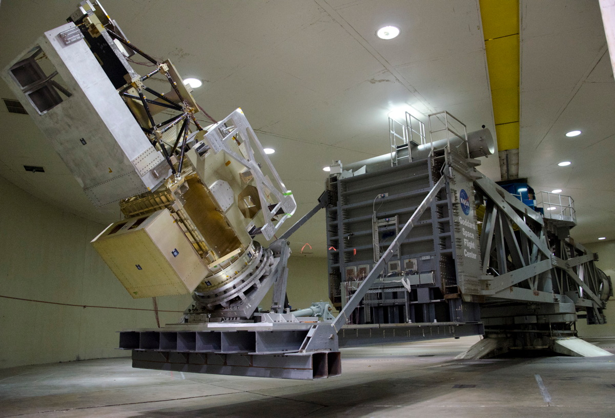
The U.S.-built instrument on GPM will tally the sum of all precipitation contained within cloud layers. The 13-channel microwave imager will improve on the resolution of a similar sensor carried aboard the TRMM satellite.
The microwave radiometer has a 3.9-foot-diameter, or 1.2-meter, spinning antenna rotating at 32 rpm.
Gail Skofronick-Jackson, NASA's deputy GPM project scientist, compares the mission to a health check-up for the planet.
With the dual-frequency radar, "we are able to have what we call a CT scan, it's a three-dimensional view of the precipitation and it's just like seeing three-dimensional within the cloud," Skofronick-Jackson says. "The GMI, on the other hand, I like to describe as an X-ray through the cloud. It's a projection of all the liquid and all the ice in the cloud.
"Just like a doctor uses CT scans and X-rays to diagnose what's happening in the human body, GPM Core Observatory is going to use the measurements of the radar and the radiometer to diagnose the precipitation strucutures within the cloud."
The spacecraft launching Thursday joins a network of already-flying international satellite missions developed by the United States, Japan, France, India and Eumetsat, the European weather satellite agency.
Researchers plan to use data from the GPM Core Observatory to calibrate microwave measurements from the other satellites, creating a uniform dataset scientists can rely on in their work.
When scientists incorporate data from the international fleet, they can get a snapshot of all precipitation on Earth every three hours, according to Skofronick-Jackson.
"Precipitation is one of the most basic and important environmental elements relating to our daily lives," Oki said. "We believe that rain and snow information observed by GPM will be to the benefit of all."
You can follow Spaceflight Now's launch coverage of NASA and JAXA's GPM satellite launch via the Mission Status Center here.
Follow Stephen Clark on Twitter @StephenClark1. You can follow Spaceflight Now on Twitter @SpaceflightNow and on Facebook.Copyright 2013 SpaceflightNow.com, all rights reserved.

Join our Space Forums to keep talking space on the latest missions, night sky and more! And if you have a news tip, correction or comment, let us know at: community@space.com.
Stephen Clark is the Editor of Spaceflight Now, a web-based publication dedicated to covering rocket launches, human spaceflight and exploration. He joined the Spaceflight Now team in 2009 and previously wrote as a senior reporter with the Daily Texan. You can follow Stephen's latest project at SpaceflightNow.com and on Twitter.

