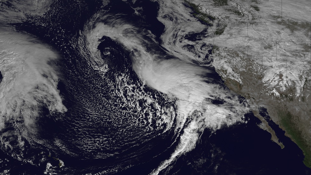
New satellite images from space reveal the storms bringing much-needed rains to California.
Yesterday (Feb. 27), a satellite image captured by the National Oceanic and Atmospheric Administration's GOES-West satellite showed one system winding down after showering the California coast, with another big front waiting offshore.
That big cyclone was expected to inundate California with heavy rains today (Feb. 28) and through the weekend. The rains should push through the Southwest and the Intermountain region and reach the Rockies by nightfall. Southern California should brace for thunderstorms and some flash flooding, meteorologists warn. The unusually bare Sierra Nevada Mountains could see a foot of snowfall during the storm.
An atmospheric river of moisture-rich air snaking across the Pacific was responsible for several inches of rain that fell around northern and central California earlier in the month. But the weekend's storms are caused by a low-pressure system that picked up tropical moisture deep in the Pacific, and its counter-clockwise orientation means it will spit a lot of that moisture out as rainfall, said Bob Benjamin, a forecaster with the National Weather Service in Monterey, Calif.
The storms, though welcome, aren't enough to make a big dent in the crushing drought that has plagued the region. Right now, about three-fourths of California is experiencing an exceptional or extreme drought, according to the U.S. Drought Monitor.
Several storms are needed to offset the year's lows, an unlikely prospect, as the wet season in California typically ends March 31.
For instance, in an average year, the San Francisco region typically receives about 17.6 inches (44.7 centimeters) of rain from July 1 to this time of year, but has received only about 6.2 inches (15.7 centimeters), according to the National Weather Service. The storms will bring only an additional inch or two or rainfall.
Get the Space.com Newsletter
Breaking space news, the latest updates on rocket launches, skywatching events and more!
Mountain snow is also at a historic low: A statewide measure taken by the Department of Water Resources yesterday estimated that snowpack water content was 24 percent of the average for this time of year.
Follow Tia Ghose on Twitter and Google+. Follow Live Science @livescience, Facebook & Google+. Original article on Live Science.
Join our Space Forums to keep talking space on the latest missions, night sky and more! And if you have a news tip, correction or comment, let us know at: community@space.com.

Tia is the assistant managing editor and was previously a senior writer for Live Science, a Space.com sister site. Her work has appeared in Scientific American, Wired.com and other outlets. She holds a master's degree in bioengineering from the University of Washington, a graduate certificate in science writing from UC Santa Cruz and a bachelor's degree in mechanical engineering from the University of Texas at Austin. Tia was part of a team at the Milwaukee Journal Sentinel that published the Empty Cradles series on preterm births, which won multiple awards, including the 2012 Casey Medal for Meritorious Journalism.

