Satellites Track Malaysian Airlines MH17 Crash Site from Space (Images)

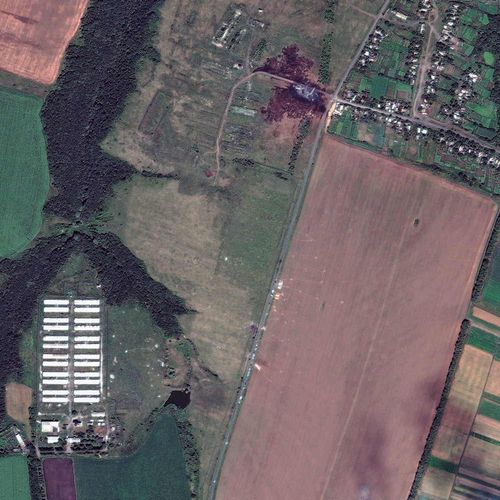
Satellite images captured the smoldering wreckage of Malaysian Airlines Flight MH17 that was shot down by a missile on July 17 in eastern Ukraine.
The images show a charred wheat field close to the village of Grabovo where the bulk of the plane went down. But the wreckage of the crash, which killed all 298 people on board, was strewn across about 13 square miles (33 square kilometers) of farmland. The Earth-observing satellites could not capture the images until Sunday (July 20) since smoke from the wreckage and cloud cover initially blocked the view.
The bird's-eye view of the site was imaged by DigitalGlobe, a company based in Colorado that programmed three of its five satellites to track the area after reports of the plane crash came flooding in. [See the top images from the DigitalGlobe contest in 2013]
The plane was shot down amid the ongoing Ukraine-Russia conflict by a surface-to-air missile fired from an area in Ukraine controlled by pro-Russian separatists. The location where the missile was fired from may have been identified by U.S. military satellites that detect heat from explosions around the world.
The attack on the plane has brought global attention to the war in Ukraine. The fighting in the region around the crash site has intensified, and on Wednesday (July 23) two Ukrainian fighter jets were shot down near the village of Dmytrivka, according to news reports.
The Netherlands has been granted control of the remains from the downed plane, which was traveling from Amsterdam to Kuala Lumpur, Malaysia. Yesterday, two military aircraft arrived in the Netherlands carrying 40 coffins filled with the first bodies of the victims, The New York Times reported.
In March, DigitalGlobe helped search for clues to a different Malaysian Airlines tragedy; Flight 370, which went missing over the Indian Ocean.
Get the Space.com Newsletter
Breaking space news, the latest updates on rocket launches, skywatching events and more!
DigitalGlobe also uses its satellites to assist emergency personnel responding to natural disasters like tornadoes or forest fires. The company plans to launch a sixth, and even more advanced satellite, later this year.
Follow Kelly Dickerson on Twitter. Follow us @Spacedotcom, Facebook or Google+. Originally published on Space.com.
Join our Space Forums to keep talking space on the latest missions, night sky and more! And if you have a news tip, correction or comment, let us know at: community@space.com.

Kelly Dickerson is a staff writer for Live Science and Space.com. She regularly writes about physics, astronomy and environmental issues, as well as general science topics. Kelly is working on a Master of Arts degree at the City University of New York Graduate School of Journalism, and has a Bachelor of Science degree and Bachelor of Arts degree from Berry College. Kelly was a competitive swimmer for 13 years, and dabbles in skimboarding and long-distance running.


