Astronaut Spies Menacing Tropical Storm Bill from Space
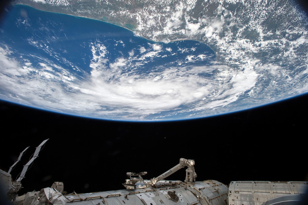
Tropical Storm Bill lurks menacingly near the coast of Texas in a photo taken from space yesterday (June 15).
The image was captured from the International Space Station, and shows the storm brewing in the Gulf of Mexico, just off the coast of the Lone Star State. The storm made landfall earlier today, on southern Matagorda Island, Texas, with maximum sustained winds of 60 mph (97 km/h), according to the National Hurricane Center.
NASA astronaut Scott Kelly took the new photo. Kelly, along with Russian cosmonaut Mikhail Kornienko, is participating in the first yearlong mission at the International Space Station to study the long-term effects of microgravity on the human body. [Earth from Above: 101 Stunning Images from Orbit]
"Concerned for all in its path including family, friends and colleagues," Kelly wrote in an update on Twitter.
Tropical Storm Bill is expected to curve across the heart of Texas, and a tornado watch has been issued for parts of central and southeast Texas, including Houston and Austin. The latest projections show that the storm will likely move into Oklahoma on Thursday (June 18).
As of 2 p.m. EDT, a swath of land from Baffin Bay, Texas, to High Island, Texas, is under a tropical storm watch. The National Oceanic and Atmospheric Administration (NOAA) estimates that Tropical Storm Bill could dump up to 12 inches (30 centimeters) of rain over some parts of eastern Texas.
More generally, Bill is expected to produce 4 to 8 inches (10 to 20 centimeters) of rain in most of eastern Texas and eastern Oklahoma, and 2 to 4 inches (5 to 10 cm) in western Arkansas and southern Missouri. Along the Texas and Louisiana coasts, storm surges could reach 2 to 4 feet (0.6 to 1.2 meters) high, according to NOAA.
Get the Space.com Newsletter
Breaking space news, the latest updates on rocket launches, skywatching events and more!
"The combination of a storm surge and the tide will cause normally dry areas near the coast to be flooded by rising waters," NOAA officials wrote in an advisory, adding that recent reports state that Port Lavaca, Texas, is already experiencing water levels 3 feet (0.9 m) above normal.
"The deepest water will occur along the immediate coast near and to the right of the landfall location," the advisory states. "Surge-related flooding depends on the relative timing of the surge and the tidal cycle, and can vary greatly over short distances."
Parts of Texas and Oklahoma are still reeling from severe storms that soaked the state in late May. Multiple storm systems dumped nearly record-breaking rains across the two states, causing flash floods in many drought-stricken areas.
Follow Live Science @livescience, Facebook & Google+. Original article on Live Science.
Join our Space Forums to keep talking space on the latest missions, night sky and more! And if you have a news tip, correction or comment, let us know at: community@space.com.

Elizabeth Howell (she/her), Ph.D., was a staff writer in the spaceflight channel between 2022 and 2024 specializing in Canadian space news. She was contributing writer for Space.com for 10 years from 2012 to 2024. Elizabeth's reporting includes multiple exclusives with the White House, leading world coverage about a lost-and-found space tomato on the International Space Station, witnessing five human spaceflight launches on two continents, flying parabolic, working inside a spacesuit, and participating in a simulated Mars mission. Her latest book, "Why Am I Taller?" (ECW Press, 2022) is co-written with astronaut Dave Williams.

