This Is an Ancient Meandering River ... On Mars
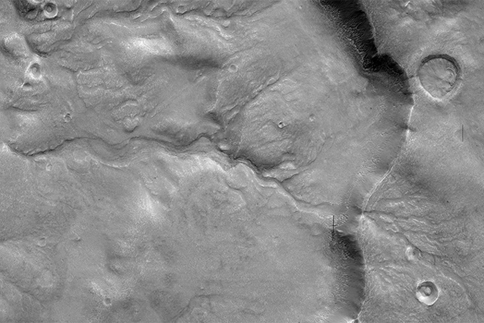
There are few more potent reminders that Mars used to be a wet world than seeing ancient, dried up river beds etched into the red planet’s surface. Although this particular example has been weathered by hundreds of thousands or even millions of years by Mars' weak winds, its beautifully preserved channel is telling us a story.
MORE: Mind-Blowing Beauty of Mars’ Dunes: HiRISE Photos
Located in Acidalia Planitia, a region dominated by a plain north of the Martian equator, this river apparently flowed from right to left, down the slope of a crater rim and into the crater itself. This image was captured by the prolific High-Resolution Imaging Science Experiment (HiRISE) camera aboard NASA’s Mars Reconnaissance Orbiter (MRO) on Sept. 25, 2015.
PHOTOS: Weirdest Mars Craters Spotted by HiRISE
It is not fully understood how rivers such as these were sourced — whether by sub-surface aquifers, meltwater or even rainfall — but through studies of the long-lost rivers of Mars from orbit we can supplement studies by surface missions (such as NASA's Mars rovers Curiosity and Opportunity) to help us piece together the puzzle of Mars’ wet past.
Source: HiRISE/Univ. of Ariz.
Originally published on Discovery News.
Get the Space.com Newsletter
Breaking space news, the latest updates on rocket launches, skywatching events and more!
Join our Space Forums to keep talking space on the latest missions, night sky and more! And if you have a news tip, correction or comment, let us know at: community@space.com.
Ian O'Neill is a media relations specialist at NASA's Jet Propulsion Laboratory (JPL) in Southern California. Prior to joining JPL, he served as editor for the Astronomical Society of the Pacific‘s Mercury magazine and Mercury Online and contributed articles to a number of other publications, including Space.com, Space.com, Live Science, HISTORY.com, Scientific American. Ian holds a Ph.D in solar physics and a master's degree in planetary and space physics.

