The Eye of Hurricane Matthew: Satellite Sees Storm's Heat from Space
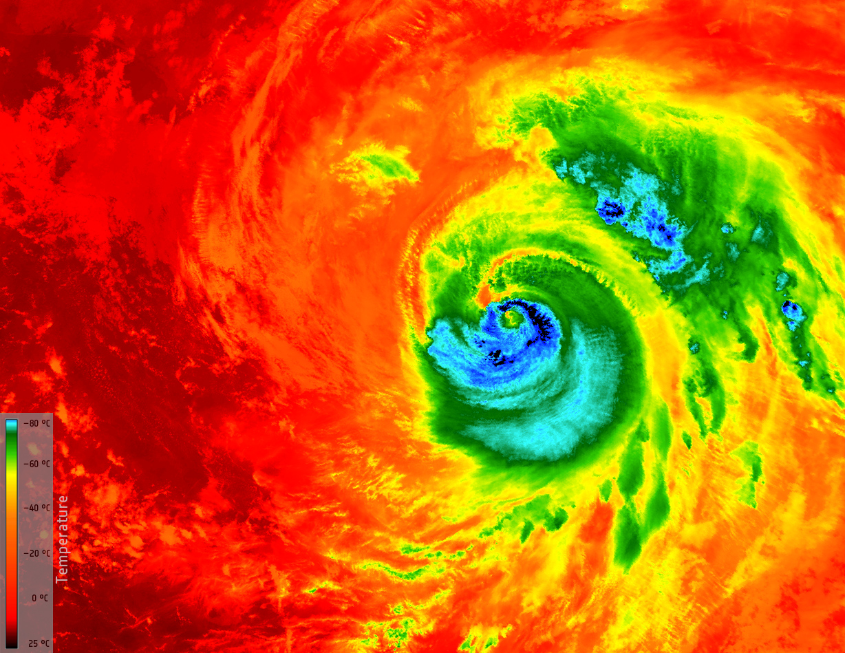
With Hurricane Matthew battering the southeastern United States, a fleet of Earth-watching weather satellites is tracking the storm from space, revealing staggering views like this temperature map of the hurricane's eye as seen from above.
The European Space Agency's Copernicus Sentinel-3A satellite captured this thermal view of Hurricane Matthew as it was approaching the eastern coast of Florida at 11:13 p.m. EDT on Thursday, Oct. 6 (0313 on Friday GMT). At the time, Matthew was monstrous, measuring 248 miles (400 kilometers) across and located 124 miles (200 km) from Miami Beach. ESA officials released the image Friday afternoon. [You can see more photos of Hurricane Matthew in this gallery by our sister site Live Science.]
"Having already caused devastation in the Caribbean, Matthew is the most powerful hurricane to threaten the U.S. Atlantic coast in more than a decade – and it is thought that it could be the most catastrophic to hit Florida in more than a 100 years," ESA officials wrote in a description of the image. [Hurricane Matthew In 3D: Satellite Views (Video)]
The Sentinel-3A satellite data found that the temperature of the clouds at the top of Hurricane Matthew ranged from minus 112 degrees Fahrenheit (minus 80 degrees Celsius) at the top of the storm, just outside its eye — 7.4 miles (12 km) above sea level — to about 77 degrees F (25 degrees C) at the Atlantic Ocean's surface. The satellite used its sea and land temperature radiometer, an instrument that measures the energy radiating from the Earth in nine spectral bands, to make these observations.
As of 5 p.m. EDT (2100 GMT), Hurricane Matthew was a Category 2 storm with maximum wind speeds of 110 mph (175 km/h), according to an update from the National Hurricane Center. It was located about 40 miles (70 km) east of Jacksonville Beach, Florida, and 135 miles (215 km) south of Savannah, Georgia, and moving north at about 12 mph (19 km/h).
The Copernicus Sentinel-3A satellite launched into space on Feb. 16 and is part of a fleet of ESA satellites designed to study Earth in extreme detail. A sister satellite to Sentinel-3A, called Sentinel-3B, is scheduled to launch in 2017.
Email Tariq Malik at tmalik@space.com or follow him @tariqjmalik and Google+. Follow us @Spacedotcom, Facebook and Google+. Original article on Space.com.
Get the Space.com Newsletter
Breaking space news, the latest updates on rocket launches, skywatching events and more!
Join our Space Forums to keep talking space on the latest missions, night sky and more! And if you have a news tip, correction or comment, let us know at: community@space.com.

Tariq is the Editor-in-Chief of Space.com and joined the team in 2001, first as an intern and staff writer, and later as an editor. He covers human spaceflight, exploration and space science, as well as skywatching and entertainment. He became Space.com's Managing Editor in 2009 and Editor-in-Chief in 2019. Before joining Space.com, Tariq was a staff reporter for The Los Angeles Times covering education and city beats in La Habra, Fullerton and Huntington Beach. In October 2022, Tariq received the Harry Kolcum Award for excellence in space reporting from the National Space Club Florida Committee. He is also an Eagle Scout (yes, he has the Space Exploration merit badge) and went to Space Camp four times as a kid and a fifth time as an adult. He has journalism degrees from the University of Southern California and New York University. You can find Tariq at Space.com and as the co-host to the This Week In Space podcast with space historian Rod Pyle on the TWiT network. To see his latest project, you can follow Tariq on Twitter @tariqjmalik.

