Solar Eclipse 2017: Traffic and Weather Forecasts for States in Totality
Updated on Aug. 19: We are just days away from the 2017 total solar eclipse, and you won't want to miss it becuase you're stuck in traffic or blanketed by a canopy of clouds. Space.com's meteorologist coluimnist Joe Rao has this weather update just for you.
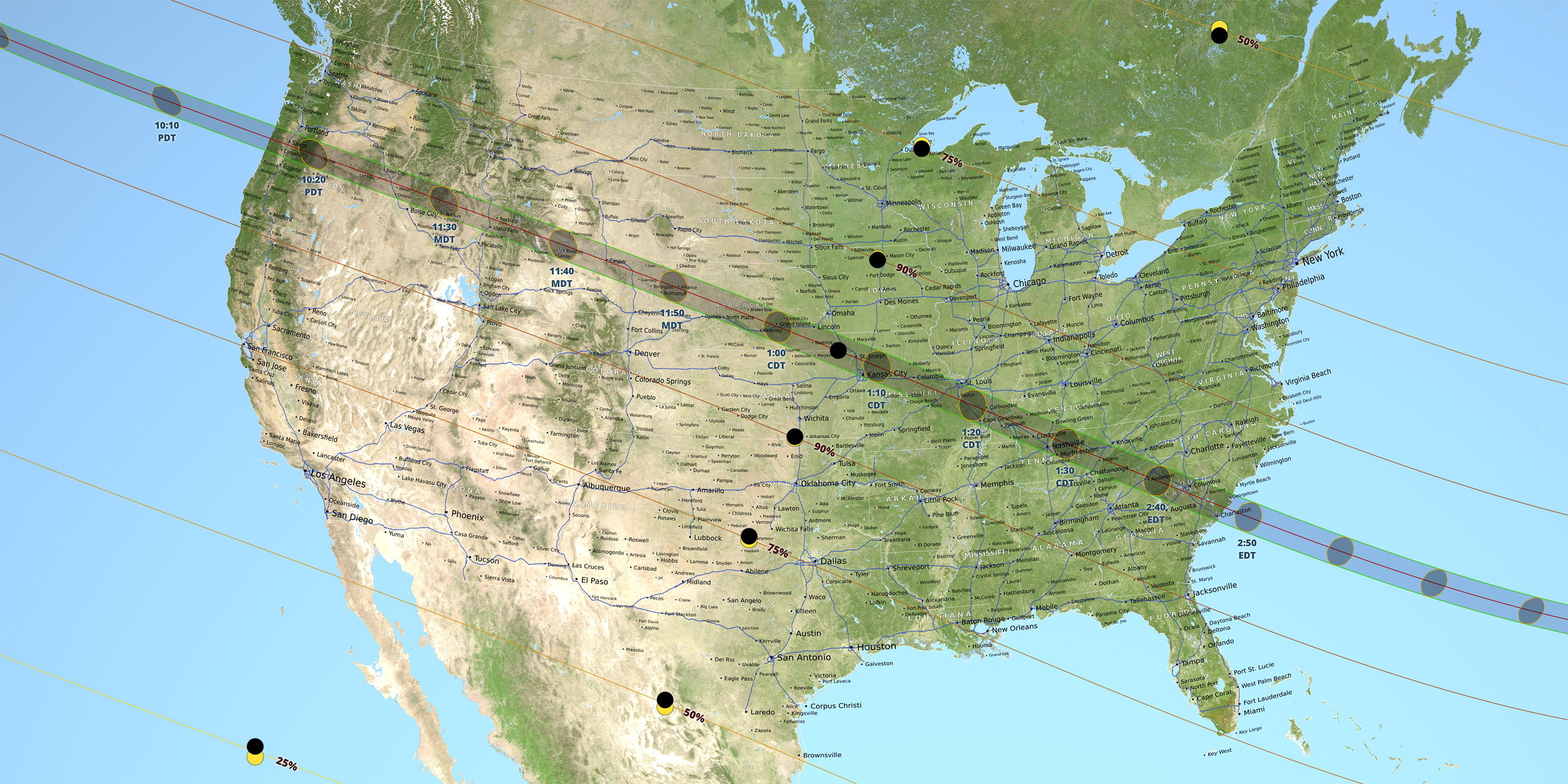
On Aug. 21, the moon will completely blot out the sun along a narrow strip of land from Oregon to South Carolina, in the first total solar eclipse visible from the United States mainland since 1979. Here's guide for what time the eclipse begins and ends for you.
Space.com is tracking the weather and traffic conditions along this 70-mile-wide (113 kilometers) "path of totality," which stretches across 14 states. Below you'll find up-to-date information to help plan your eclipse-viewing adventure. [Here Are the Best Maps of the 2017 Solar Eclipse (and a Printable Poster)]
A few quick words of advice: Stay flexible, and be open to viewing the eclipse from a relatively out-of-the way site within the path of totality, such as a state park or national forest. And arrive at your preferred viewing spot at least a day in advance, to give yourself time to seek out a less crowded or sunnier area if need be. Some of the places discussed below will doubtless get very crowded on Aug. 21.
Oregon
Traffic Prediction: The eclipse will make landfall on the U.S. mainland in Oregon, just north of the town of Newport. The moon's shadow will then move eastward through the northern part of the state, cutting across several major highways in the process — notably, Interstate 5 in the west and Interstate 84 in the east. There may be heavy traffic on I-5, as people from Portland and Eugene head south and north, respectively, to get into the path of totality. For updates, see: http://www.tripcheck.com/Pages/RCMap.asp
Popular Viewing Sites:
Get the Space.com Newsletter
Breaking space news, the latest updates on rocket launches, skywatching events and more!
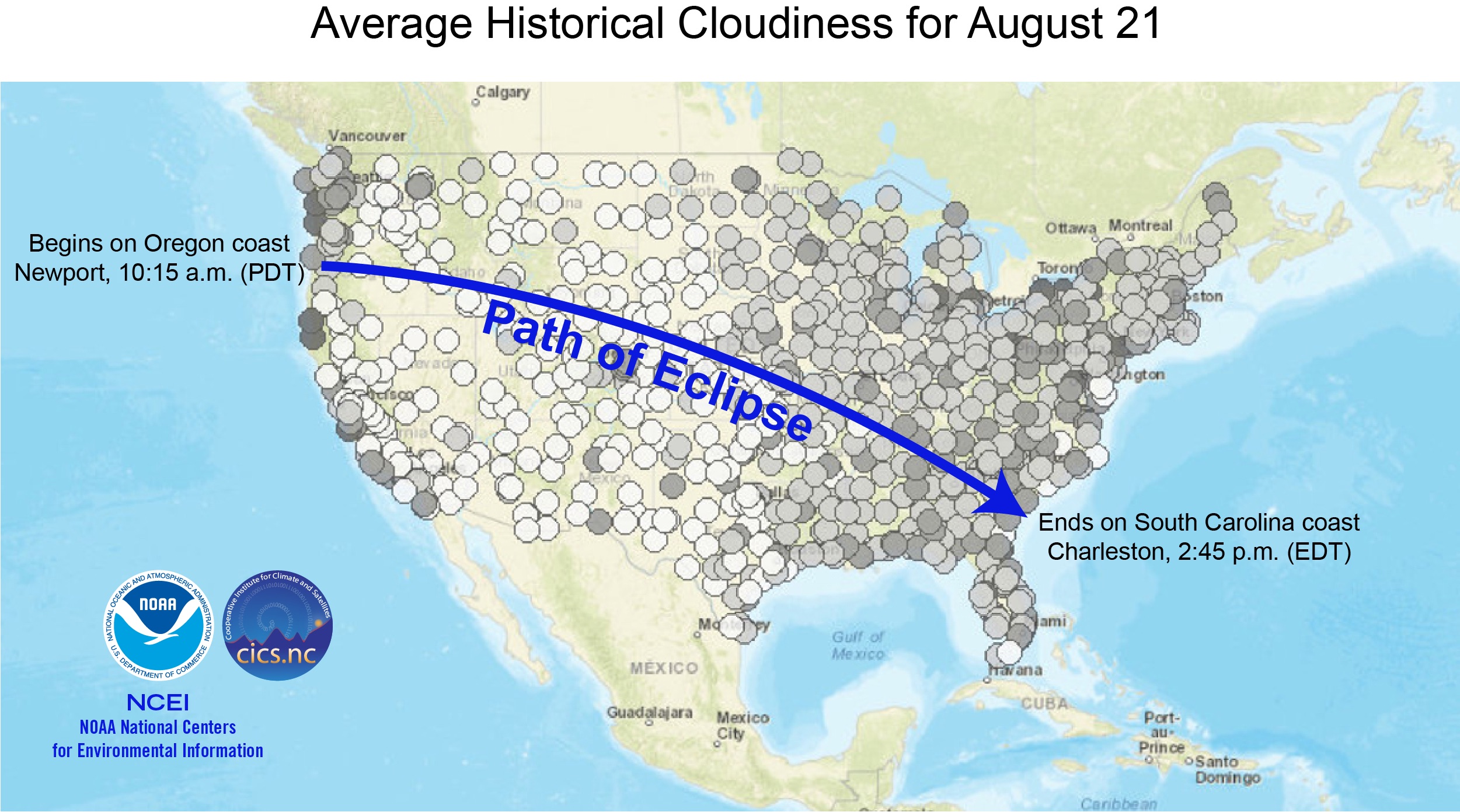
- Newport and environs: Many people will likely flock to this area to see the eclipse make landfall. That's an exciting prospect, but keep in mind that the Oregon coast can be a pretty cloudy place — cloudier than the state's interior, anyway. Indeed, historical data show there's a 56 percent chance that the view from Newport will be adversely affected by clouds, according to the National Oceanic and Atmospheric Administration's National Centers for Environmental Information (NCEI) and the Cooperative Institutes for Climate and Satellites-North Carolina (CICS-NC). (This information comes from the interactive "cloudiness map" that NCEI and CICS-NC have put together for the entire totality path; you really should check it out, no matter where you're heading on Aug. 21.) You can keep up with Newport traffic here and Newport weather here.
- Madras: This city in west-central Oregon is billed as one of the top locations from which to see the Aug. 21 eclipse. It sits at the confluence of four highways and is just a two-hour drive from Portland, so it'll be relatively easy to get to (provided traffic isn't too bad). Skies should be clear, too; in Redmond, just down the road from Madras, there's a mere 12 percent chance that clouds will affect the view, according to the NCEI and CICS-NC. (This translates to a "viewable percentage" of 88, as NCEI and CICS-NC term it.) Madras traffic updates can be found here, and weather updates here.
Likelihood of Rainfall: August is one of the driest months in Oregon, which tends to receive most of its precipitation in the winter months. For example, Newport gets an average of just 0.8 inches (2.1 centimeters) of precipitation in August, compared with 10.8 inches (27.5 cm) in December, according to Current Results. For Madras, those figures are 0.3 inches (0.9 cm) and 1.4 inches (3.5 cm), respectively.
Idaho
Traffic Prediction: The totality path sweeps across Idaho's broad southern stretch, from Weiser in the west through the Snake River Valley in the east. Much of this region is sparsely populated national forest land, with small towns sprinkled here and there. There aren't many highways in the area, so some may get clogged if hordes descend upon them. Go here for traffic updates.
Popular Viewing Sites:
- Weiser: This city in far-western Idaho is right off a major highway, and sits on the banks of the famous Snake River to boot. And the weather should be good; nearby Ontario, Oregon, has a 93 viewable percentage, according to the NCEI and CICS-NC. Traffic updates here and weather updates here.
- Rexburg: Rexburg, all the way across the state, is pretty much right on the totality path's center line, giving viewers there an extra-long look at the eclipse. Indeed, totality will last 2 minutes and 17 seconds in Rexburg — 36 seconds longer than in Idaho Falls, which is not far south. And Rexburg has a viewable percentage of 91. Traffic updates here and weather updates here.
Likelihood of Rainfall: As in Oregon, August is generally dry in Idaho. For example, Weiser and Rexburg get an average of just 0.3 inches (0.9 cm) of and 0.7 inches (1.8 cm) of precipitation in that month, according to the site U.S. Climate Data. Weiser's average annual rainfall is 12.1 inches (30.7 cm), and Rexburg's is 13.3 inches (33.8 cm).
Montana
The path of totality does cut through Montana, but just barely; less than 8 square miles (21 square km) of the state will witness the total solar eclipse, according to Eclipse2017.org. And that tiny patch of land is unpopulated, remote and rugged. If you're thinking about planning an eclipse adventure there, Eclipse2017.org has some helpful info here.
Wyoming
Traffic Prediction: Wyoming is like Idaho — lots of open space connected by country highways, which may get quite crowded around towns and cities on Aug. 21. Go here for traffic updates.
Popular Viewing Sites:
- Jackson: This city in the shadow of the Grand Tetons offers spectacular scenery every day, so it and surrounding areas will likely attract lots of folks on Aug. 21. Jackson doesn't have an entry on the NCEI and CICS-NC map, but Big Piney, which isn't far south, has an 88 viewable percentage. Traffic updates here and weather updates here.
- Casper: Casper will also be a popular destination. This city in east-central Wyoming boasts great weather prospects (88 viewable percentage), and it's easy to get to (and away from) via four big highways. Traffic updates here and weather updates here.
Likelihood of Rainfall: Jackson gets 1.42 inches (3.6 cm) of rain in August, out of an annual total of about 16.9 inches (42.9 cm), according to U.S. Climate Data. Casper is drier, receiving 0.87 inches (2.2 cm) of rain in August and 12.5 inches (31.8 cm) over the course of a year.
Nebraska
Traffic Prediction: The eclipse's arrival in Nebraska marks the end of its time in the Rocky Mountain West and the start of its journey through the Great Plains and Midwest. As the moon's shadow moves east, it will darken the rooftops of more and more people — but there's still plenty of wide-open space in Nebraska. Go here for Nebraska traffic updates.
Popular Viewing Sites:
- Alliance: Three highways go through or near this small city on the western edge of Nebraska's famous Sand Hills region. Alliance is quite close to the center of the totality path, and it usually offers good weather (82 viewable percentage). Traffic updates here and weather updates here.
- Grand Island: This city in south-central Nebraska is also close to the totality path's center; the total eclipse there will last about 2.5 minutes. Weather could be a bit more of an issue here, however; the viewable percentage is 74. Traffic updates here and weather updates here.
Likelihood of Rainfall: According to U.S. Climate Data, Alliance gets 1.54 inches (3.9 cm) of its 15.4 inches (39.1 cm) of average annual rainfall in August. The numbers for Grand Island are 3.11 inches (7.9 cm) and 26.6 inches (67.6 cm), respectively.
Iowa
Iowa is even more of a fringe player in the Aug. 21 eclipse than Montana is: Just 450 acres (180 hectares) of the Hawkeye State lie in the path of totality, according to Eclipse2017.org. So you're probably not planning an eclipse trip to Iowa.
Kansas
Traffic Prediction: The path of totality hits a slice of northeastern Kansas, an area of small cities connected by a web of highways. These roads could get busy as people from Topeka drive up to get a look. Go here for traffic updates.
Popular Viewing Site:
- Hiawatha: This city is close to the shadow path's center line and sits at the junction of two highways. Hiawatha's viewable percentage is likely similar to that of nearby Falls City, Nebraska (74). Traffic updates here and weather updates here.
Likelihood of Rainfall: Robinson, which is just down the road from Hiawatha, gets 3.78 inches (9.6 cm) of its 34.2 inches (86.9 cm) of average annual rainfall in August, according to the site U.S. Climate Data.
Missouri
Traffic Prediction: A lot of people are getting involved now, just by default. Two big cities in Missouri — St. Louis and Kansas City — fall within the path of totality (though only barely; parts of both cities lie outside it). So you're going to want to check traffic updates if you're headed to the Show Me State.
Popular Viewing Sites:
- St. Joseph: This city in northwestern Missouri is right in the totality path's center and will be an eclipse headquarters of sorts. As GreatAmericanEclipse.com notes, astronomers and skywatchers will hold a viewing party at St. Joseph's Rosecrans Memorial Airport. St. Joseph has a 78 viewable percentage, according to NCEI and CICS-NC. Traffic updates here and weather updates here.
- Columbia: The college town of Columbia, in the middle of the state, is also close to the center line; indeed, viewers there will see the total eclipse for nearly as long as folks in St. Joseph (2 minutes and 36 seconds, compared with 2 minutes and 38 seconds). But Columbia's weather is a little iffier; the viewable percentage is 70. Traffic updates here and weather updates here.
Likelihood of Rainfall: About 4.37 inches (11.1 cm) of rain falls in Columbia in August, out of a yearly total of 42.6 inches (108.2 cm), according to U.S. Climate Data. According to HomeFacts.com, St. Joseph gets about 3.63 inches (9.2 cm) of rain in August and about 28.6 inches (72.6 cm) in an average year.
Illinois
Traffic Prediction: The totality path doesn't come close to Chicago, instead slicing across far-southern Illinois. But this less-populated area will likely be pretty busy, because it boasts the spot that will be totally eclipsed the longest on Aug. 21 (see below). Go here for traffic updates.
Popular Viewing Site:
- Carbondale area: Much of Illinois' southern tip will offer great viewing for the eclipse. And a spot in the forest southeast of Carbondale will experience the total eclipse for 2 minutes and 42 seconds on Aug. 21 — longer than any other place. So Carbondale will draw lots of folks, who are invited to a viewing event hosted by Southern Illinois University. The weather is likely to cooperate; Carbondale has an 80 viewable percentage. Traffic updates here and weather updates here.
Likelihood of Rainfall: Carbondale gets about 3.27 inches (8.3 cm) of rain in August and 47.2 inches (119.9 cm) all year, according to U.S. Climate Data.
Kentucky
Traffic Prediction: Western Kentucky offers a wealth of great viewing opportunities and could be attractive to folks seeking to escape the crowds expected in and around Carbondale. Go here for traffic updates.
Popular Viewing Sites:
- Paducah: This city isn't right on the center line, but viewers there will still get about 2 minutes and 20 seconds of total-eclipse darkness. And Paducah has a 77 viewable percentage. Traffic updates here and weather updates here.
- Hopkinsville: Hopkinsville is smack in the totality path's center, so you'd experience about 20 seconds more of totality here than you would in Paducah. And, as in other center-line spots, there will be eclipse festivities in Hopkinsville. Traffic updates here and weather updates here.
Likelihood of Rainfall: About 2.76 inches (7.0 cm) of rain falls in Paducah in August, out of a yearly total of 49.1 inches (124.7 cm), according to U.S. Climate Data. Hopkinsville gets about 3.46 inches (8.8 cm) and 51.1 inches (129.8 cm), respectively.
Tennessee
Traffic Prediction: The moon's shadow pretty much bisects this long, skinny state, but several large cities (Memphis, Chattanooga and Knoxville, for example) will not be treated to totality. So Tennessee's highways could get pretty crowded with folks headed for darker skies. Go here for traffic updates.
Popular Viewing Sites:
- Nashville: Tennessee's capital isn't that close to the path's center line, but it will get more than 1 minute and 50 seconds of totality. Clouds may be an issue, however; the city has a viewable percentage of just 44, according to the NCEI and CICS-NC. Traffic updates here and weather updates here.
- Crossville: This city east of Nashville is closer to the center line and could be a better bet, weather-wise; it has a 66 viewable percentage. Traffic updates here and weather updates here.
Likelihood of Rainfall: Nashville's average rainfall in August and the entire year are 3.19 inches (8.1 cm) and 47.2 inches (119.9 cm), respectively. For Crossville, the numbers are 3.98 inches (10.1 cm) and 55.1 inches (140.0 cm), respectively.
North Carolina
Traffic Prediction: The path of totality goes through the far western tip of North Carolina. It could get quite busy here as folks from miles around descend on this scenic part of the Appalachian Mountains. Go here for traffic updates.
Popular Viewing Site:
- Great Smoky Mountains National Park: This famous patch of land on the Tennessee-North Carolina border draws more visitors annually than any other national park in the nation. So it will probably be a popular destination for eclipse watchers on Aug. 21, even though it lies north of the totality path's center line. Nearby Asheville has a viewable percentage of 65. You can get up-to-date information about traffic here, and weather updates here.
Likelihood of Rainfall: Nearby Gatlinburg, Tennessee, gets about 4.57 inches (11.6 cm) of rain in August and 55.2 inches (140.2 cm) in a typical year, according to U.S. Climate Data.
Georgia
Traffic Prediction: Georgia is another state that just gets nicked by the totality path; only people in Georgia's extreme northeastern corner will be treated to a total eclipse. That means a lot of folks from Atlanta (and smaller cities, such as Athens) could head to this area to get a better view. Go here for traffic updates.
Popular Viewing Site:
- Clayton: Two highways run through this city of a few thousand people in the Blue Ridge Mountains. And Clayton will get about 2 minutes and 35 seconds of totality, according to Eclipse2017.org. The closest location to Clayton on the cloudiness map — Clemson, South Carolina — has a 75 viewable percentage. But weather prospects in Clayton may be a bit worse than that, considering how rainy the city is (see below). Traffic updates here and weather updates here.
Likelihood of Rainfall: Clayton gets about 5.83 inches (11.6 cm) of rain in August and 68.9 inches (140.2 cm) over the course of a year, according to U.S. Climate Data.
South Carolina
Traffic Prediction: South Carolina is the end of the line for the Aug. 21 eclipse, unless you have a boat. The moon's shadow will bid farewell to the U.S. mainland on the state's sandy beaches, which will likely draw lots of folks who wish to wave goodbye. Go here for traffic updates.
Popular Viewing Sites:
- Columbia: The state capital will be treated to about 2.5 minutes of total eclipse, and numerous highways go through or around the city. This accessibility could be both a blessing and a curse, drawing many people into the city from far afield. Clouds could be a factor; the NCEI and CICS-NC give two divergent viewable percentages for Columbia — 44 and 76. Traffic updates here and weather updates here.
- McClellanville: This is the last American city the totality path will hit, so it's a good choice for people who want to watch the eclipse head out to sea and disappear. But don't be shocked if the weather doesn't cooperate: August is the rainiest month in McClellanville, and the closest city on the interactive cloudiness map, Charleston, has a 53 viewable percentage. Traffic updates here and weather updates here.
Likelihood of Rainfall: Columbia gets an average of 4.84 inches (12.3 cm) of rain in August and 46.3 inches (117.6 cm) over the course of a year, according to U.S. Climate Data. McClellanville gets 6.54 inches (16.6 cm) and 53.5 inches (135.9 cm), respectively.
Editor's note: Space.com has teamed up with Simulation Curriculum to offer this awesome Eclipse Safari app to help you enjoy your eclipse experience. The free app is available for Apple and Android, and you can view it on the web. If you take an amazing photo of the Aug. 21 solar eclipse, let us know! Send photos and comments to: spacephotos@space.com.
Follow Mike Wall on Twitter @michaeldwall and Google+. Follow us @Spacedotcom, Facebook or Google+. Originally published on Space.com.
Join our Space Forums to keep talking space on the latest missions, night sky and more! And if you have a news tip, correction or comment, let us know at: community@space.com.

Michael Wall is a Senior Space Writer with Space.com and joined the team in 2010. He primarily covers exoplanets, spaceflight and military space, but has been known to dabble in the space art beat. His book about the search for alien life, "Out There," was published on Nov. 13, 2018. Before becoming a science writer, Michael worked as a herpetologist and wildlife biologist. He has a Ph.D. in evolutionary biology from the University of Sydney, Australia, a bachelor's degree from the University of Arizona, and a graduate certificate in science writing from the University of California, Santa Cruz. To find out what his latest project is, you can follow Michael on Twitter.
