Exploring the Apollo Moon Missions Using Mobile Apps
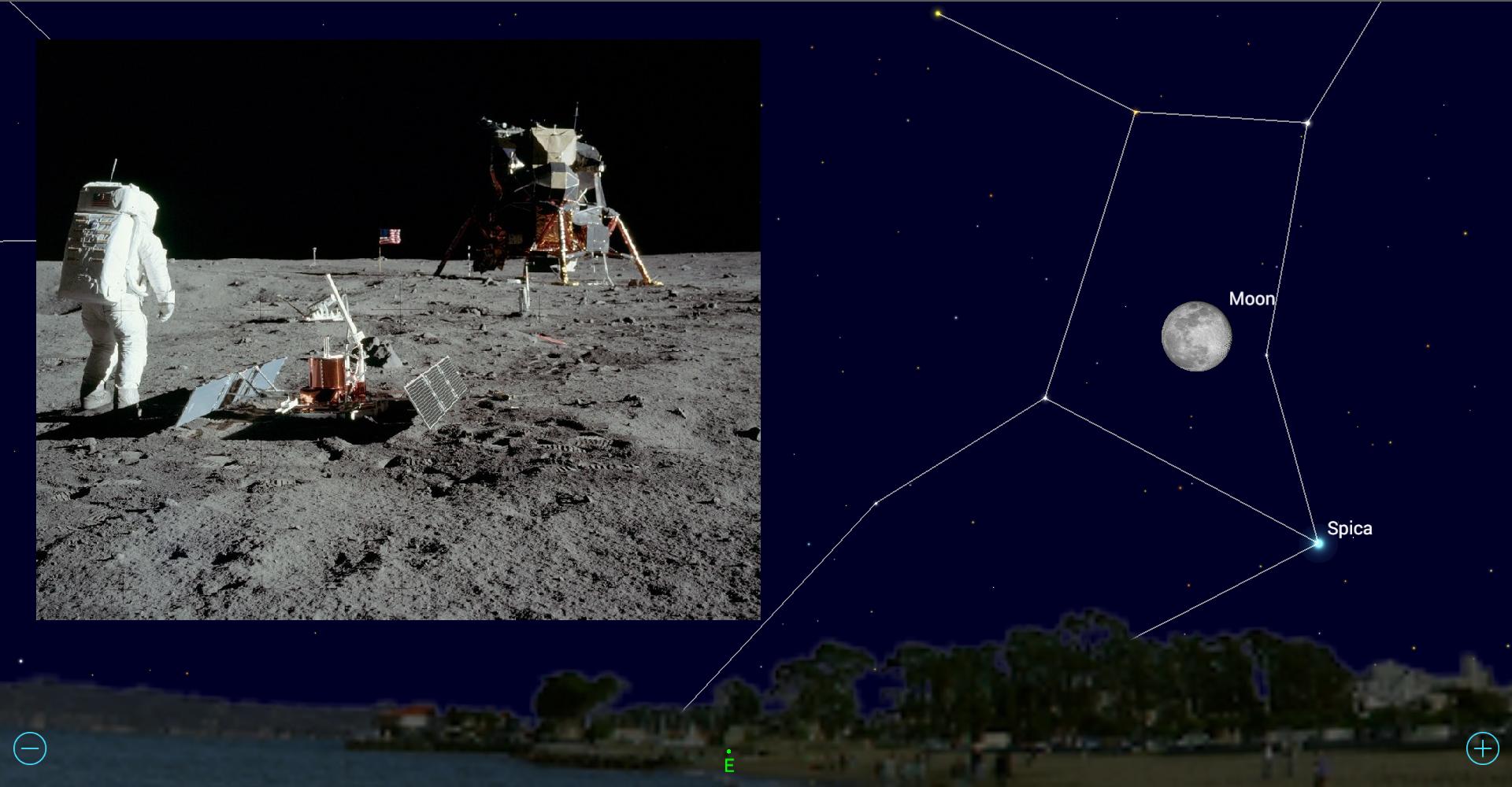
Next summer will mark the 50th anniversary of the Apollo 11 mission — when humans first set foot on another celestial object. The Lunar Excursion Module descent stages, scientific equipment, U.S. flags, and the footprints and rover tire-tracks of all six Apollo missions are still on the lunar surface. While we can't see those things from Earth, we can see where the astronauts landed and understand what they were sent to learn.
During the upcoming full moon, sunlight will illuminate all of the Apollo landing sites, making it a perfect time to head outside on a clear evening and appreciate the missions' contributions to science.
In this edition of Mobile Astronomy, we'll describe some of what the Apollo missions accomplished and tell you how to use mobile apps to find where those missions landed. We'll also highlight special aspects of those areas that you can see using binoculars and backyard telescopes. [Moon Memories: Thousands of Apollo Photos Released Online]
A little lunar history
Even without magnification it's easy to see that the moon's surface is composed of two distinctly different types of terrain. The bright regions that cover 83 percent of the moon, especially the southern portion of the side that faces Earth, are heavily cratered highlands that consist mainly of a fine-grain and low-density rock called anorthosite.
With an age of almost 4.5 billion years, the highlands are the oldest parts of the moon's crust. Scientists believe that the moon was formed about 100 million years after Earth, when an object the size of Mars struck the planet in a glancing blow that tore off part of Earth's crust. That material formed a ring around the young planet, and this ring later coalesced into the moon. The anorthosite floated to the surface and cooled slowly after the moon's formation, allowing the rock's mineral crystals to grow larger and become more reflective.
The heavy bombardment that formed our moon continued for about a billion years. Many large objects, which were left over after the formation of the planets, slammed into the young moon to excavate enormous round basins, produce craters of all sizes and shatter the surface rocks.
The dark areas we see on today's moon consist of a dense, iron-rich, coarse-grain rock called basalt. It's commonly found in volcanic areas on Earth, too. The heavy lunar basalts sank into the interior of the moon as it cooled after its formation. Starting around 3.7 billion years ago, and lasting for about 700 million years, some event caused the basalts to flow upward and out, filling the large, low-lying ancient basins to form flat "seas" of dark rock. We call these areas "maria" (Latin for "sea"). The maria basalts are roughly 0.62 to 2.5 miles (1 to 4 kilometers) thick. The moon's far side has almost no maria regions, probably because the lunar crust is much thicker there.
Get the Space.com Newsletter
Breaking space news, the latest updates on rocket launches, skywatching events and more!
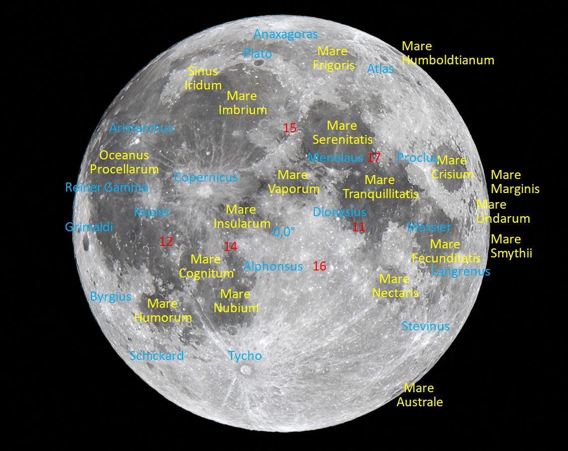
The system for naming the features on the moon was introduced in 1651 by Jesuit astronomer Giovanni Battista Riccioli. At the time, before advanced telescopes were available, it was widely believed that the dark areas were water. Riccioli's names for the large maria, and their smaller counterparts — the "lacus" (lake), "palus" (swamp) and "sinus" (bay) features — were taken mainly from weather terms, such as was the case for Oceanus Procellarum (Ocean of Storms), Mare Imbrium (Sea of Showers) and Mare Nubium (Sea of Clouds). (Mare is the singular form of maria.) Many astronomy apps provide the option to display labels on moon features.
The visual moon
Because the Apollo mission landing sites are widely distributed across the moon's near side, the only time all six are lit simultaneously is when the moon is within days of its full moon phase. When locating them, it is helpful to be familiar with the full moon's major features. (Refer to my labeled full moon image.)
Traditionally, many people have perceived on the natural satellite's surface the face of a "Man in the Moon." Others have identified a jumping rabbit, with its body made from Oceanus Procellarum and Mare Imbrium on the left, its head by Mare Serenitatis, and its ears formed by the narrow maria Fecunditatis and Nectaris on the moon's far right side. I see a woman's face in profile. She is turned to the left and crowned with dark hair composed of Mare Serenitatis and Mare Tranquillitatis. Her eye is Mare Vaporum and her smile is Mare Insularum. I think she looks like Wilma Flintstone! The lady is also wearing a bright pendant at her throat, represented by the crater Tycho.
The large, bright patch in front of the lady's face, located just to the upper left of the moon's center, is the huge crater Copernicus. Its impactor punched a hole through the dark basalt, exposing the older, brighter anorthosite underneath and spreading it over the surrounding dark maria. The spray of bright material is called a ray system.
Studying features like this helps scientists to understand the history of the moon. The impact that formed Copernicus had to occur after the maria were deposited. In fact, based upon Apollo samples, scientists estimate that Copernicus formed relatively recently, about 800 million years ago.
Below, we'll cover where the six successful Apollo missions landed, what they hoped to find and what we learned about the moon thanks to each outing. To help you navigate your way around, let's look at how we indicate directions on the moon.
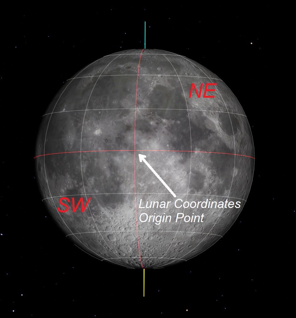
By convention, the direction where the sun rises on any solar system body is that body's east. For someone standing on the Earth's Northern Hemisphere and looking at the moon, lunar east is toward the right — the side from which the moon waxes more fully. (This sometimes confuses people, because your right hand will point west on Earth when you're looking at the moon from the Northern Hemisphere.)
North on the moon is upward — the same as on Earth. The moon's central meridian, which separates its eastern and western hemispheres, is a north-south line that passes through the corner of the lady's mouth. The moon's equator passes through the same spot, making this the origin for the lunar coordinate system.
Finally, the round edge of the moon is called the limb. So, an object located near the northeastern limb of the moon is in the extreme upper right. (To make this easy to remember, just pretend that you are reading a road map, where north is up and east is to the right.)
The Apollo mission objectives and results
The Apollo science experiments included active and passive seismic stations used to probe the moon's crust and interior structure and to record moonquakes. The missions' astronauts used electromagnetic instruments to characterize the subsurface stratigraphy and electrical properties, magnetometers to measure the direction and intensity of the moon's local magnetic field, and temperature sensors to measure the heat flowing from the moon's interior.
Other instruments were deployed to measure the effects of the sun and cosmic rays on the lunar surface. But, arguably, the most important goal was to collect and return rock samples to Earth, where scientists could analyse the finds' compositions, compare their isotopic abundances to those of Earth rocks and meteorites, and determine how long ago the minerals in the rocks crystallized. By determining the ages of rocks from various locations, scientists can read the moon's history.
NASA sent Apollo 11, the first crewed mission to the moon's surface, to Mare Tranquillitatis, the "Sea of Tranquility," located in the moon's eastern hemisphere near the equator. The site was expected to be level, smooth, and relatively free of craters and boulders, allowing for a safe touchdown and liftoff of the Lunar Excursion Module (LEM). Later analysis of the returned rock samples confirmed that the mare was indeed composed of basalts that range in age from 3.88 billion to 3.57 billion years old.
Apollo 12 was sent to Oceanus Procellarum, the "Ocean of Storms." It was also near the equator, but in the moon's western hemisphere. As another mare, it was also chosen as a safe landing site, though it had a few more craters. The samples brought back were younger basalts (3.29 billion to 3.08 billion years old), which exhibited a slightly reddish color. Researchers hoped that the astronauts could also collect some material blown out from the impact that formed Copernicus, called ejecta, so that researchers could find the age of the moon's original crust. But none of the samples could be definitively matched to Copernicus.
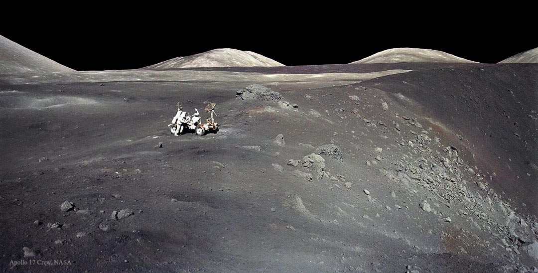
Apollo 14 was a more challenging mission. NASA sent the spacecraft to the Fra Mauro Highlands, a hilly region with white lunar anorthosite on the surface south of the large, round Mare Imbrium. (Apollo 13 was on its way to that area, before it had to return home after a mission-ending accident.) The mission's objectives included collecting samples of material blasted out when the Imbrium Basin was formed. Studying this material would help scientists pin down when the event happened and give them access to rocks excavated from deep within the moon's crust. The samples were indeed dated as 3.8 billion to 3.9 billion years old; however, they weren't pristine — they had been mixed with younger rocks by cratering in the intervening years.
Apollo 15 was an advanced mission sent to a northern region of the moon — Hadley Ridge (Rima) and the Apennine mountain range, which forms the curved edge of Mare Imbrium. Here, researchers expected to be able to sample complex geology: a mix of highlands, Imbrium basalts, ancient Imbrium Basin ejecta, and more-recent crater breccias and melts, which are rocks mixed together by the heat and pressure of an impact. The returned samples contained some surprises, including volcanic basalt with green glass. [Apollo 15 Lunar Landing Mission (Photos)]
For a change of pace, Apollo 16 landed in the Plain of Descartes, well away from any of the maria. Scientists hoped to sample the pristine lunar crust material of the highlands. Some was found, but most of the rocks consisted of ancient Imbrium and Nectaris basin ejecta.
Finally, for Apollo 17, the target was a boundary between highlands and mare in the northeastern region of the moon — Taurus-Littrow, where Mare Serenitatis and Mare Tranquillitatis connect. Astronauts returned samples of a dark-colored deposit about 3.64 billion years old that consisted of orange and black volcanic fragments with a high-titanium basalt composition. The astronauts also collected a light-colored rock from an avalanche deposit that was caused only 108 million years ago by the impact of ejecta from Tycho crater, located about 1250 miles (2000 km) away!
Next, I'll tell you how to find the Apollo sites on the moon and see the regions for yourself, with the aid of mobile astronomy apps.
Finding the Apollo landing sites on the moon
To ensure that all of the Apollo landing sites on the moon are visible, you'll need to head out on a clear night when the moon is close to its full phase. (The next full moons occur on March 31 and April 29.) The directions I give below are designed for visual or binocular viewing. When using a telescope, remember that your optics may invert and/or mirror-image the view. And don't expect to see the Apollo equipment on the surface — it's far too tiny to spot using amateur telescopes!
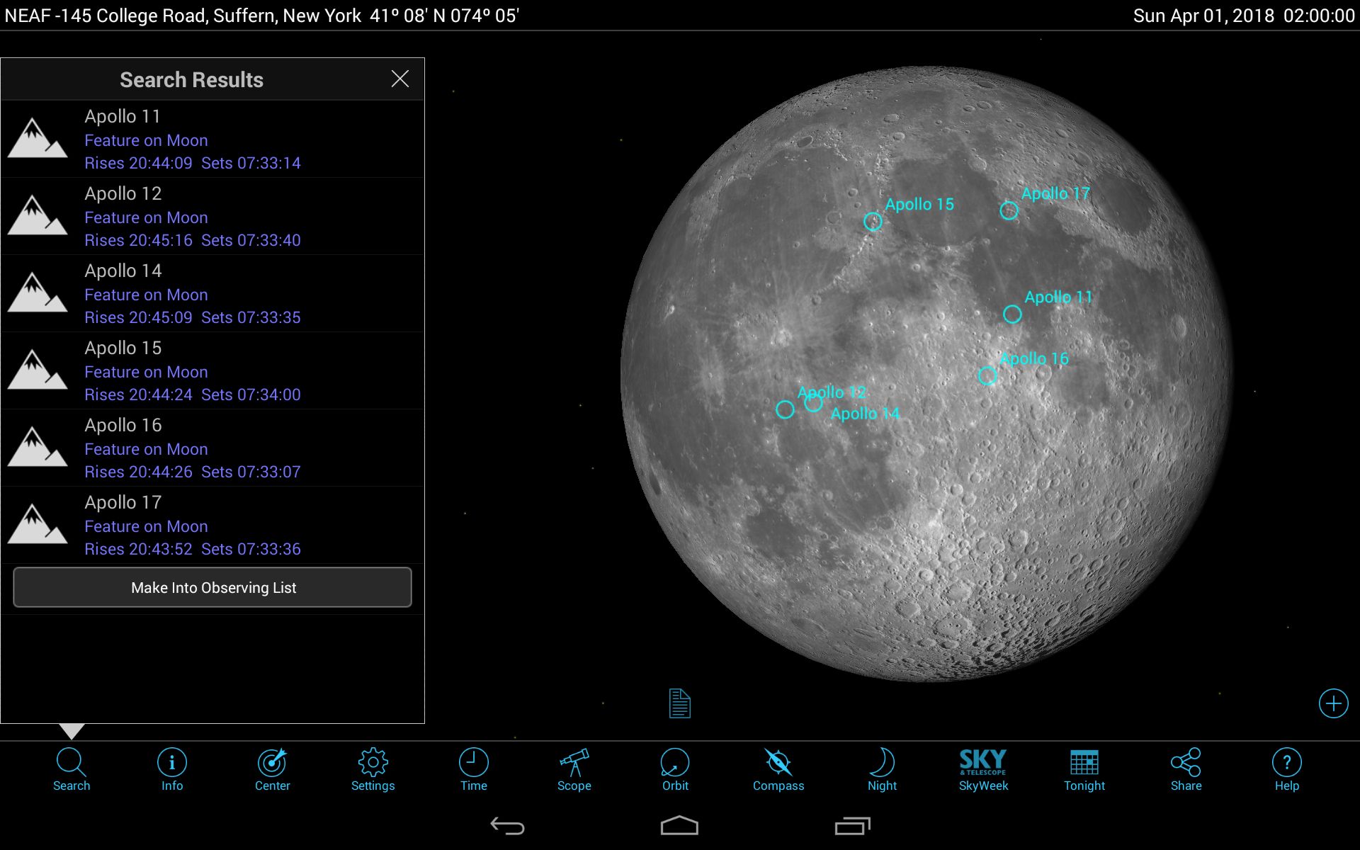
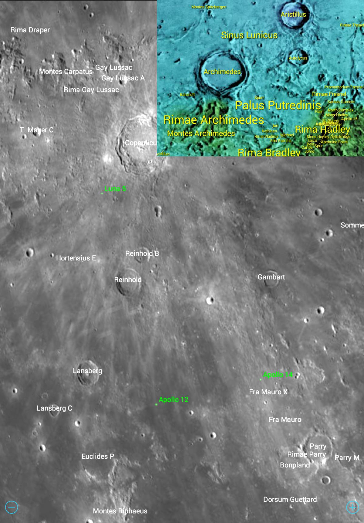
Many astronomy apps allow you to center and enlarge the moon and display the Apollo landing sites. In the SkySafari 6 app, tap Solar System under the Settings menu and put a check mark in the With Surface Labels option. The Apollo sites will be displayed using a green dot and label, while the lunar features will be labeled in white. If the moon appears dark in your app, advance to a date close to a full moon. The landing site labels may not appear if there are too many other features nearby. To solve this problem, open the Search menu, type "Apollo 11" (or whichever mission number you wish) and hit return. At the mission information page, tap Center.
In the Star Walk 2 app, you can select the moon and tap its name to open an information screen. There, you can tap the Satellite icon to display the labeled Apollo landing sites, or you can display the lunar feature labels by tapping the Moon icon.
It will also help to have the moon oriented upright, with bright Tycho toward the bottom. Around full moon periods, the moon sits upright over the southern horizon in late evening. Keeping the app centered on the moon, adjust the hour until the moon rotates to an angle you think is best.
The site of Apollo 11 is near the equator and halfway to the moon's eastern limb. It's just above the southern edge of Mare Tranquillitatis, immediately above the ear of our Lady in the Moon. A small, but very bright and round crater named Dionysius sits just to the west. Mare Tranquillitatis is known to have a bluish-tinted, titanium-enriched basalt. By comparing it to Mare Serenitatis, you can observe its darker tone using unaided eyes or binoculars.
The Apollo 12 landing site is well below, and between, the two large craters Kepler and Copernicus — just to the northwest of the bright, curved boundary that separates Oceanus Procellarum from Mare Cognitum. A bent line of three small, bright craters sits just to the northeast of the site. In binoculars or a telescope, look for the rays of Copernicus ejecta extending southwestward across the landing site.
Apollo 14 landed in a narrow zone of dark basalts just south of the tip of the lady's chin. Mare Insularum lies to the north and Mare Cognitum is to the south. Look for Copernicus rays running toward the southeast and bright Tycho rays appearing with a north-south orientation.
Along the bright, curved eastern boundary of Mare Imbrium, is the Apollo 15 site, found a short distance below a dark-colored break in that curve. Look for a large patch of darker basalt to the southwest of the landing site.
Apollo 16's landing site is not as easy to find. Look for the large, round crater Theophilus at the northwestern edge of Mare Nectaris. It has an obvious central peak. Sweep west for a similar-looking, but much smaller crater named Kant. Now, continue the same distance west again, and you're there. Bright rays from Tycho should cross the area running diagonally toward the northeast.
Finally, Apollo 17 landed at the southwestern tip of the bright prominence that divides the maria Serenitatis and Tranquillitatis. A small, bright crater with a dark center sits just to the southeast of the site. Remember to compare the colors of the two maria.
And that's it! Whether or not you successfully locate the Apollo sites, you'll be certain to discover plenty of interesting sights on the moon. And if your astronomy app labels the locations for the many robotic missions that have landed on the natural satellite, see if you can determine what type of terrain they were investigating. [20 Most Marvelous Moon Missions]
Going beyond
To explore the surface of the moon in detail, in your easy chair or through your telescope, I recommend the free LunarMap Lite or the inexpensive LunarMap HD apps for Android. These apps offer seven zoomable maps of the near side and five of the far side of the moon, including detailed photographic imagery of the Lunar Reconnaissance Orbiter, false-colored digital-elevation models and vintage lunar charts. You can flip and/or mirror-image the maps so that they match your telescope's view. Tapping a feature label brings up details about the object's size and lunar coordinates, the origin of the name, the meaning of the feature type, and a link to the online Moon Wiki database for more details.
The next edition of Mobile Astronomy will be posted just in time for the April new moon, so we'll focus on spring galaxies. In the meantime, keep looking up!
Editor's note: Chris Vaughan is an astronomy public outreach and education specialist at AstroGeo, a member of the Royal Astronomical Society of Canada, and an operator of the historic 74-inch (1.88 meters) David Dunlap Observatory telescope. You can reach him via email, and follow him on Twitter @astrogeoguy, as well as on Facebook and Tumblr.
This article was provided by Simulation Curriculum, the leader in space science curriculum solutions and the makers of the SkySafari app for Android and iOS. Follow SkySafari on Twitter @SkySafariAstro. Follow us @Spacedotcom, Facebook and Google+. Original article on Space.com.
Join our Space Forums to keep talking space on the latest missions, night sky and more! And if you have a news tip, correction or comment, let us know at: community@space.com.
Chris Vaughan, aka @astrogeoguy, is an award-winning astronomer and Earth scientist with Astrogeo.ca, based near Toronto, Canada. He is a member of the Royal Astronomical Society of Canada and hosts their Insider's Guide to the Galaxy webcasts on YouTube. An avid visual astronomer, Chris operates the historic 74˝ telescope at the David Dunlap Observatory. He frequently organizes local star parties and solar astronomy sessions, and regularly delivers presentations about astronomy and Earth and planetary science, to students and the public in his Digital Starlab portable planetarium. His weekly Astronomy Skylights blog at www.AstroGeo.ca is enjoyed by readers worldwide. He is a regular contributor to SkyNews magazine, writes the monthly Night Sky Calendar for Space.com in cooperation with Simulation Curriculum, the creators of Starry Night and SkySafari, and content for several popular astronomy apps. His book "110 Things to See with a Telescope", was released in 2021.

