Hurricane Satellites Reveal Flooding on Earth

PHOENIX — Researchers examining data produced by small satellites launched in 2016 to track ocean winds were surprised the mission produced valuable information on soil moisture and flooding.
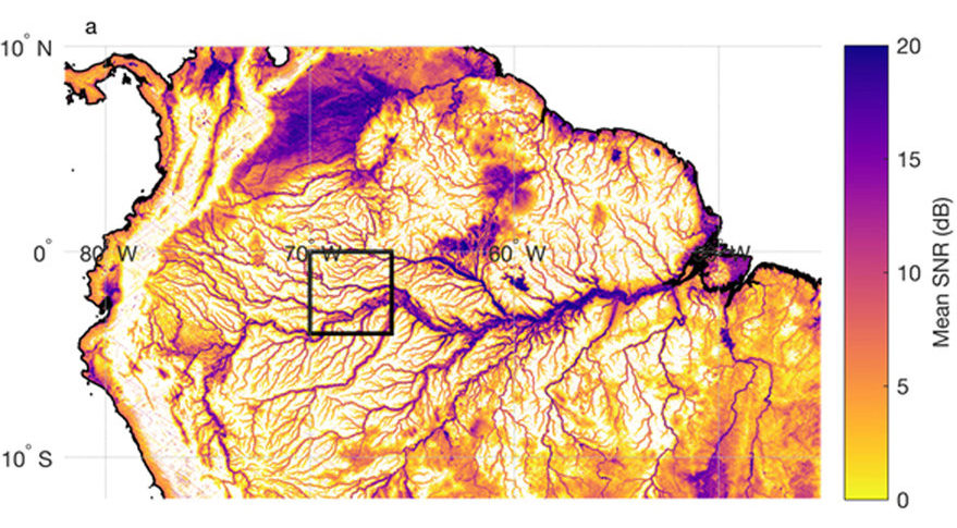
NASA's Cyclone Global Navigation Satellite System, a constellation of eight 30-kilogram satellites built by the Southwest Research Institute and the University of Michigan, observed the Amazon River basin in far more detail than NASA's Soil Moisture Active Passive mission even when SMAPs radar still worked.
"These images got us excited about the potential for doing new land-applications science with the Cygnus data," said Chris Ruf, CYGNSS principal investigator and University of Michigan climate and space science professor. "Now a number of people on the science team are working on soil moisture retrieval algorithms and flood inundation algorithms based on these early results." [Watch NASA Launch CYGNSS Satellites to Track Hurricanes]
Clara Chew of the University Corporation for Atmospheric Research published in August Amazon River basin flood maps with observations from SMAP's radar and radiometer as well as CYGNSS. SMAP's radiometer offered 30-kilometer resolution and its radar three-kilometer resolution compared with roughly 500-meter resolution for CYGNSS.
CYGNSS is good at picking up soil moisture near the surface and revealing flooding, Chew said at the American Meteorological Society conference here.
Two years into the mission, CYGNSS also is working well in its intended job: observing ocean winds at the core of tropical cyclones, Ruf said.
Initially, CYGNSS data on high winds did not match observations made by the National Oceanic and Atmospheric Administration's hurricane-hunting airplanes. Since then, CYGNSS data products have been refined.
Get the Space.com Newsletter
Breaking space news, the latest updates on rocket launches, skywatching events and more!
CYGNSS' eight satellites spaced 12 minutes apart provided valuable measurements of winds associated with Typhoon Trami, which struck Japan in September. "With the frequency of sampling, we can do things like capture rapid intensification," Ruf said.
On remaining challenge for CYGNSS program officials is correcting data produced by the satellite's Delay Doppler Mapping Instrument as a result of the variability in GPS signals.
The U.S. government increases or decreases GPS signal strength in response to jamming. "We don't know beforehand," Ruf said. "We are developing real-time correction algorithms."
This story was provided by SpaceNews, dedicated to covering all aspects of the space industry.
Join our Space Forums to keep talking space on the latest missions, night sky and more! And if you have a news tip, correction or comment, let us know at: community@space.com.
Debra Werner is a correspondent for SpaceNews based in San Francisco. She earned a bachelor’s degree in communications from the University of California, Berkeley, and a master’s degree in journalism from Northwestern University. Debra is a recipient of the 1989 Gerald Ford Prize for Distinguished Reporting on National Defense. Her SN Commercial Drive newsletter is sent out on Wednesdays.


