Mars Rock Pile Shows a Layered History
For the first time, a series of rock layers on Mars has revealeda timeline of the past in striking clarity, with no digging required.
Onthe surface of it
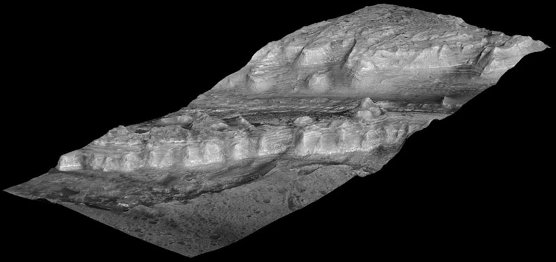
Near thecenter of a Martian crater about the size of Connecticut, exposed rock layersform a mound as tall as the Rockies and reveal a record of major environmentalchanges on Mars billions of years ago.
According toa new report by geologists using instruments on NASA's Mars ReconnaissanceOrbiter, the history told by this tall parfait of layers inside Gale Cratermatches what has been proposed in recent years as the dominant planet-widepattern for early Mars.
"Lookingat the layers from the bottom to the top, from the oldest to the youngest, yousee a sequence of changing rocks that resulted from changes in environmentalconditions through time," said Ralph Milliken of NASA's Jet PropulsionLaboratory, Pasadena, CA. "This thick sequence of rocks appears to beshowing different steps in the drying-out of Mars."
Usinggeological layers to understand stages in the evolution of a planet's climatehas a precedent on Earth. A change about 1.8 billion years ago in the types ofrock layers formed on Earth became a key to understanding a dramatic change inEarth's ancient atmosphere.
Feat ofclay
Get the Space.com Newsletter
Breaking space news, the latest updates on rocket launches, skywatching events and more!
Milliken andtwo co-authors report in Geophysical Research Letters that clayminerals, which form under very wet conditions, are concentrated in layers nearthe bottom of the Gale stack. Above that, sulfate minerals are intermixed withthe clays. Sulfates form in wet conditions and can be deposited when the waterin which they are dissolved evaporates. Higher still are sulfate-containinglayers without detectable clays. And at the top is a thick formation ofregularly spaced layers bearing no detectable water-related minerals.
Rock exposureswith compositions like various layers of the Gale stack have been mappedelsewhere on Mars, and researchers, including Jean-Pierre Bibring of theUniversity of Paris, have proposed a Martian planetary chronology ofclay-producing conditions followed by sulfate-producing conditions followed bydry conditions. However, Gale is the first location where a single series oflayers has been found to contain these clues in a clearly defined sequence fromolder rocks to younger rocks.
"If youcould stand there, you would see this beautiful formation of Martian sedimentslaid down in the past, a stratigraphic section that's more than twice theheight of the Grand Canyon, though not as steep," said Bradley Thomson ofthe Johns Hopkins University Applied Physics Laboratory, Laurel, MD. He andJohn Grotzinger of the California Institute of Technology in Pasadena areMilliken's co-authors.
NASAselected Gale Crater in 2008 as one of four finalist sites for the Mars ScienceLaboratory rover, Curiosity, which has a planned launch in 2011. The finalistsites all possess exposures of water-related minerals, but also contain distinguishingfeatures.
Multi-instrumentalist
Three instruments on NASA's Mars Reconnaissance Orbiterhave provided key data about the layered mound in Gale Crater. Images from theHigh Resolution Imaging Science Experiment camera reveal details used to maphundreds of layers. Using stereo pairs of the images, the U.S. GeologicalSurvey has generated three-dimensional models used to discern elevationdifferences as small as a meter (about a yard). Observations by the Compact ReconnaissanceImaging Spectrometer for Mars yielded information about minerals on thesurface. The Context Camera provided broader-scale images showing how thelayers fit geologically into their surroundings.
Thomson said, "This work demonstrates the synergy ofthe instruments on the Mars Reconnaissance Orbiter. We wouldn't have ascomplete a picture if we were missing any of the components."
The mission has been studying Mars since 2006.
- Get to Know MRO: Top10 Facts About NASA?s Mars Reconnaissance Orbiter
- DiscoveryIndicates Mars Was Habitable
- Lookingfor Water on Mars
Join our Space Forums to keep talking space on the latest missions, night sky and more! And if you have a news tip, correction or comment, let us know at: community@space.com.

Space.com is the premier source of space exploration, innovation and astronomy news, chronicling (and celebrating) humanity's ongoing expansion across the final frontier. Originally founded in 1999, Space.com is, and always has been, the passion of writers and editors who are space fans and also trained journalists. Our current news team consists of Editor-in-Chief Tariq Malik; Editor Hanneke Weitering, Senior Space Writer Mike Wall; Senior Writer Meghan Bartels; Senior Writer Chelsea Gohd, Senior Writer Tereza Pultarova and Staff Writer Alexander Cox, focusing on e-commerce. Senior Producer Steve Spaleta oversees our space videos, with Diana Whitcroft as our Social Media Editor.
