NASA uncovers hidden system of mysteriously draining lakes under Antarctica
The lakes grow and shrink beneath the ice.
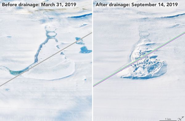
Scientists have discovered two new lakes buried deep beneath the Antarctic Ice Sheet.
These hidden gems of frigid water are part of a vast network of ever-changing lakes hidden beneath 1.2 to 2.5 miles (2 to 4 kilometers) of ice on the southernmost continent. These lakes fill and drain over and over again in largely mysterious cycles that may influence how fast the ice sheet moves and how and where meltwater reaches the Southern Ocean. This flow, in turn, can change the currents in the Southern Ocean and potentially affect ocean circulation worldwide.
"It's not just the ice sheet we're talking about," study leader Matthew Siegfried, a geophysicist at the Colorado School of Mines, said in a statement. "We're really talking about a water system that is connected to the whole Earth system."
Related: Photos of Antarctica: The ice-covered bottom of the world
Hidden water
The lakes sit at the bottom of the ice sheet, where the ice meets the rocky Antarctic continent. Unlike in Greenland, where meltwater flows from the ice surface through crevasses and holes called moulins, Antarctica's lakes form from beneath the ice, probably as a result of pressure, friction and perhaps geothermal heat.
This water system was largely invisible until the advent of NASA's ICESat mission in 2003. The ICESat satellite used lasers to precisely measure the elevation of Antarctic ice. In 2007, Scripps Institution of Oceanography glaciologist Helen Amanda Fricker connected the elevation changes measured by ICESat to the dynamics of the lakes deep beneath the ice surface. As the lakes drain and fill, the ice above rises and falls, offering hints as to what's happening below.
Fricker's breakthrough opened up the possibility of tracking the lake system over time. ICESat, however, collected data for only six years. Its European Space Agency equivalent, CryoSat-2, collected similar data starting in 2010 but over a broader area and with less precision. In September 2018, NASA launched a new satellite, ICESat-2, which collects the highest-precision data yet.
Get the Space.com Newsletter
Breaking space news, the latest updates on rocket launches, skywatching events and more!
"ICESat-2 is like putting on your glasses after using ICESat: The data are such high precision that we can really start to map out the lake boundaries on the surface," Siegfried said.
A dynamic system
In the new study, Siegfried and Fricker combined data from ICESat, CryoSat-2 and ICESat-2 to trace changes in the subglacial lake system from October 2003 to July 2020. They focused on three areas with good satellite coverage and known active lakes: the boundary between the Mercer and Whillans ice streams in West Antarctica; the lower MacAyeal Ice Stream, also in West Antarctica; and the upper Academy Glacier in East Antarctica.
At the Mercer and Whillans boundary, the researchers found two new lakes, which they dubbed the Lower Conway Subglacial Lake and the Lower Mercer Subglacial Lake. They also found that what was thought to be one lake under the MacAyeal ice stream was actually two.
Over time, these lakes experienced major change. The lakes beneath the Mercer and Whillans ice stream boundary are currently undergoing their third period of drainage in 17 years. Meanwhile, all of the lakes beneath the MacAyeal ice stream have followed their own patterns of draining and filling. The lowermost lake went through four fill-drain events during the study period, each taking only about a year to complete. The second lake drained between 2014 and 2015 and is currently filling up again, while the third lake drained just slightly between 2016 and 2017. Meanwhile, the lakes beneath Academy Glacier drained between 2009 and 2018.
All of these changes are puzzle pieces in scientists' understanding of the speed and direction of Antarctica's ice sheet flow. Already, researchers are finding the links between the under-ice lakes and the ocean: In January, a study co-authored by Fricker found that the drainage of one lake on the Amery Ice Shelf in East Antarctica flushed as much as 198 billion gallons (750 billion liters) into the ocean in only three days, Live Science reported at the time.
The new study was published July 7 in the journal Geophysical Research Letters.
Originally published on Live Science
Join our Space Forums to keep talking space on the latest missions, night sky and more! And if you have a news tip, correction or comment, let us know at: community@space.com.

Stephanie Pappas is a contributing writer for Space.com sister site Live Science, covering topics ranging from geoscience to archaeology to the human brain and behavior. She was previously a senior writer for Live Science but is now a freelancer based in Denver, Colorado, and regularly contributes to Scientific American and The Monitor, the monthly magazine of the American Psychological Association. Stephanie received a bachelor's degree in psychology from the University of South Carolina and a graduate certificate in science communication from the University of California, Santa Cruz.

