2024 hurricane season should be busy, NOAA says
"We need to be prepared for the possibility of a very active hurricane season."
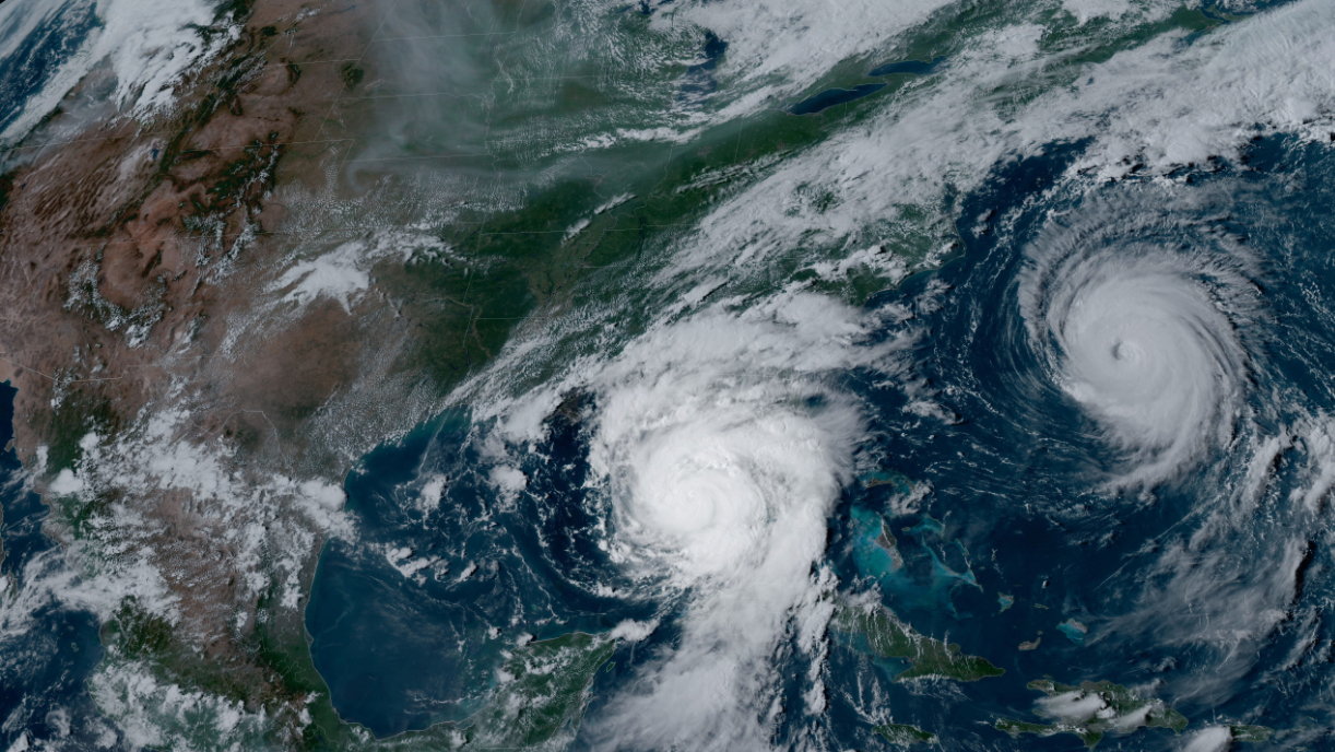
With La Nina conditions evolving in the Pacific and near-record warm waters in the Atlantic, scientists expect the 2024 Atlantic hurricane season to be a busy one.
Forecasters at the Climate Prediction Center (CPC), part of the U.S. National Oceanic and Atmospheric Administration's (NOAA) National Weather Service, release an outlook every year ahead of hurricane season that includes what kind of storm activity they predict between June 1 and Nov. 30.
CPC researchers say there's an 85% chance that this year's hurricane season will be more active than normal, with the potential for 17 to 25 named storms (which boast wind speeds of at least 39 mph, or 63 kph). The outlook also predicts that eight to 13 of those storms will develop into hurricanes (which have winds of at least 74 mph, or 119 kph), with four to seven strengthening to major hurricane status. A major hurricane is anything that reaches at least Category 3 on the Saffir-Simpson scale — meaning it has sustained winds of at least 111 mph (179 kph). A "typical" hurricane season has 14 named storms with seven hurricanes, three of which are major.
Related: Powerful Hurricane Jova spotted from space (video)
A number of factors are conspiring to make the 2024 season especially active. To set the stage for tropical storm systems, you need warm ocean water, with a minimum temperature of 80 degrees Fahrenheit (27 degrees Celsius), plenty of moisture in the air and low vertical wind shear, or minimal wind speed and direction change with height.
With water temperatures already spiking to near-record levels across the Atlantic, that first box is already checked heading into hurricane season. There's plenty of heat energy available for storms to soak up like a sponge, fueling storms as an abundance of moisture is produced in the air. To complete the recipe for the "perfect storm," you need low vertical wind shear, which can historically occur more often depending on the current phase of the El Niño-Southern Oscillation (ENSO). ENSO is a climate pattern in which the water temperature in the central and eastern Pacific Ocean becomes warmer or cooler than normal. In addition, there's a seesaw effect with the strength of trade winds and vertical wind shear.
We've been in one of the strongest "El Nino" climate patterns ever recorded, but scientists report that this phase is ending and predict "La Nina" conditions will follow. What we typically see during a La Nina period is a decrease in wind shear in the tropics, which makes Earth's atmosphere a lot less stable and much more favorable for storms to develop and strengthen.
Get the Space.com Newsletter
Breaking space news, the latest updates on rocket launches, skywatching events and more!
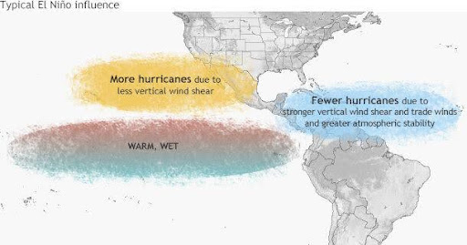
A good example of this was the 2005 Atlantic hurricane season. This was a single-year La Nina and was the busiest storm season on record, with 15 hurricanes — including the devastating Hurricane Katrina.
"La Nina tends to bring more hurricane activity than normal in the Atlantic, and the unusually warm tropical Atlantic Ocean should only enhance the likelihood of enhanced activity," Nat Johnson, a scientist on NOAA's ENSO team and with the agency's Geophysical Fluid Dynamics Laboratory, told Space.com. "We need to be prepared for the possibility of a very active hurricane season."
Related: Climate 'points of no return' may be much closer than we thought
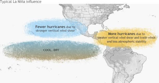
In addition, there's concern that it will also be an above-normal West African monsoon season. This would result in an increased chance of waves coming from Africa that could turn into powerful tropical systems with longer lifespans in the Atlantic. As those waves interact with the conditions set forth from a La Nina pattern (and the ingredients mentioned above), storms have more opportunity to develop, grow and intensify — perhaps doing so extremely rapidly. This happened with Hurricane Maria, which went from a Category 1 hurricane to Category 5 in less than a day before ravaging the northeastern Caribbean in 2017.
"It's important to note that some of the strongest storms to hit the U.S. underwent rapid intensification within a few days before landfall, so not all storms will give us a lot of time to get prepared if we wait," Ken Graham, director of the National Weather Service, told Space.com. "All of the ingredients are in place for a very active hurricane season; it's a reason to be concerned, but not alarmed. I hope there will be at least some missing or weak ingredients to limit the number or strength of storms this season. Use this time to your advantage. Take the time now to put together a plan and a preparedness kit so that you're ready for what the season may bring."
NOAA is working to get us all ready, by ramping up forecast communications, decision support and storm recovery efforts. For example, the agency plans to release more text products in Spanish to provide important storm updates; generate experimental forecast cones that focus on inland hazards in addition to coastal ones during storm events; and increase the cadence of storm watches, warnings and advisories as needed.
There will also be new tools to analyze hurricanes and help with forecasting. These include a pair of forecast models focused on what fuels hurricane intensity and the probability of rapid intensification, improved flood inundation mapping, and an experimental graphic with forecast rainfall totals for the Caribbean and Central America. There will also be upgrades to observation systems of oceanic and atmospheric conditions, which will allow forecasters to gain a better understanding of hurricanes and make better predictions.
"With another active hurricane season approaching, NOAA's commitment to keeping every American informed with life-saving information is unwavering," NOAA Administrator Rick Spinrad said in a statement on May 23. "AI-enabled language translations and a new depiction of inland wind threats in the forecast cone are just two examples of the proactive steps our agency is taking to meet our mission of saving lives and protecting property."
Join our Space Forums to keep talking space on the latest missions, night sky and more! And if you have a news tip, correction or comment, let us know at: community@space.com.

Meredith is a regional Murrow award-winning Certified Broadcast Meteorologist and science/space correspondent. She most recently was a Freelance Meteorologist for NY 1 in New York City & the 19 First Alert Weather Team in Cleveland. A self-described "Rocket Girl," Meredith's personal and professional work has drawn recognition over the last decade, including the inaugural Valparaiso University Alumni Association First Decade Achievement Award, two special reports in News 12's Climate Special "Saving Our Shores" that won a Regional Edward R. Murrow Award, multiple Fair Media Council Folio & Press Club of Long Island awards for meteorology & reporting, and a Long Island Business News & NYC TV Week "40 Under 40" Award.
-
Cisventure Astronot How unprecedented is this? Is this a "Used to happen every 30 years, but now it's much more common.", or more like a "there's never been a year this bad."? Sources are appreciated.Reply -
Classical Motion I don't know about you but I hear this every spring. Along with an un-presidented cicada invasion.Reply -
Unclear Engineer The parameters that are "unprecedented" are the surface temperatures of the Atlantic Ocean , the Caribbean Sea and the Gulf of Mexico, in combination with a change to La Nina condition in the Pacific Ocean, which tends to not disrupt the formation of hurricanes in the Atlantic basin.Reply
I recently read a nice report that talked about the previous historical transitions from the El Nino condition and the La Nina condition and what followed in the way of Atlantic hurricanes, and I thought I saved the link, but can't find that now. A quick search did not find the same article, but, for some discussion, see https://theconversation.com/hurricane-forecast-points-to-a-dangerous-2024-atlantic-season-with-la-nina-and-a-persistently-warm-ocean-teaming-up-to-power-fierce-storms-228351 .

