Raging California wildfires spotted from space (photos, video)
Smoke is billowing hundreds of miles out to sea.
Earth-orbiting satellites have spotted the wildfires ripping through Northern California.
As record-high temperatures hit the U.S. West Coast this past week, wildfires began to spread rapidly in a region west of Sacramento, quickly growing to encompass 124,000 acres (50,000 hectares), according to the New York Times. As the fires rage on, they are being monitored by Earth-orbiting satellites and experiments onboard the International Space Station.
On Tuesday (Aug. 18), California Gov. Gavin Newsom declared a state of emergency due to the fires, which have so far forced tens of thousands of evacuations, according to a statement from NASA. One part of Northern California has so many fires caused by lightning from summer storms that the region is now known as the LNU Lightning Complex.
Related: Satellite images show Australia's devastating wildfires from space
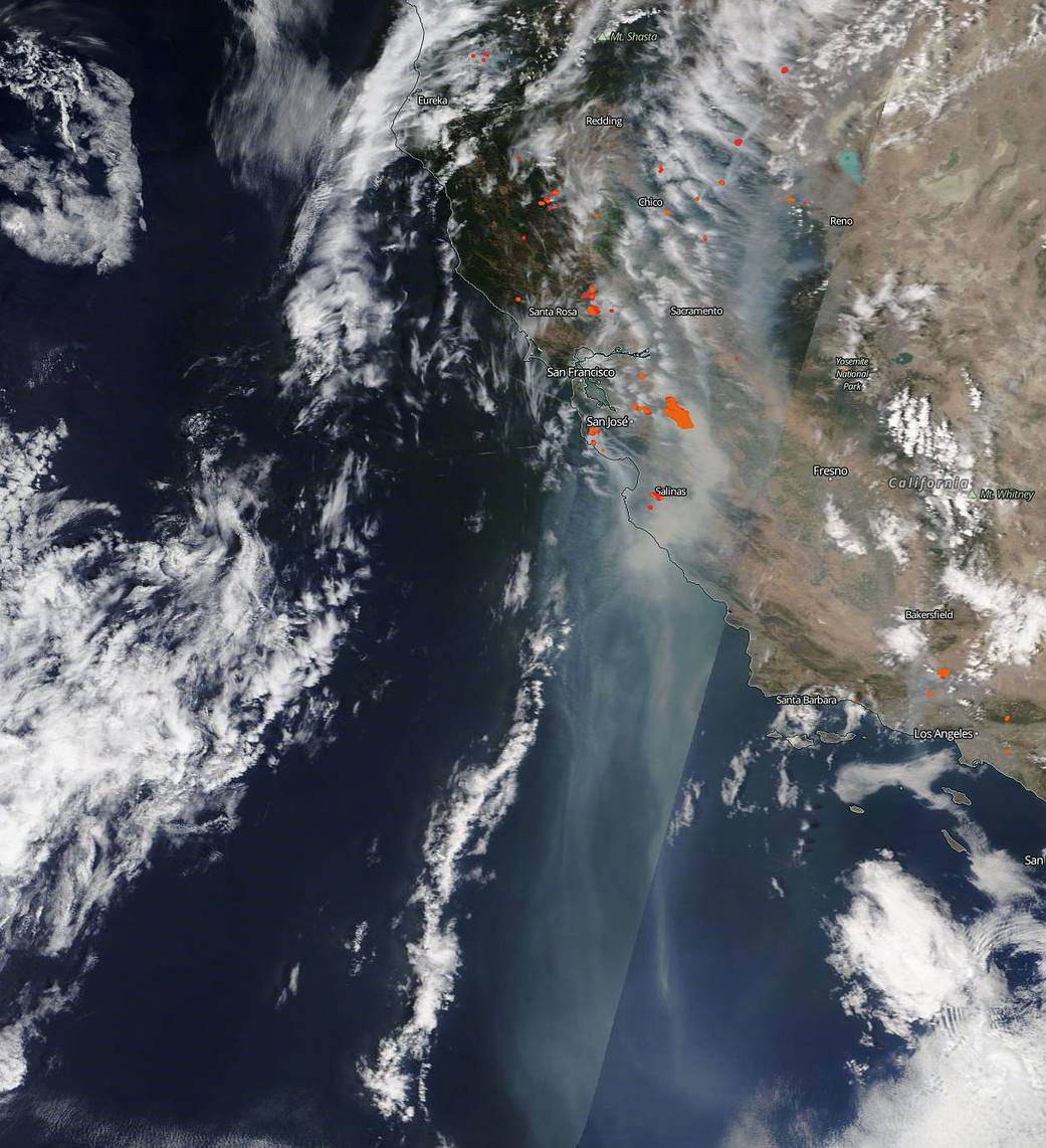
On Wednesday (Aug. 19), NASA's Terra satellite caught sight of billowing smoke clouds spilling off of the California coast. Hot and dry conditions expected to extend across the state throughout the weekend (at least) could support continued fires and even additional wildfire outbreaks, according to the same NASA statement.
In order to fully assess conditions in California as they evolve, NASA uses its Earth Observing System Data and Information System Worldview application. With this system, the agency can analyze the high-resolution images captured by satellites like Terra.
SATELLITE SPOTLIGHT: @NOAA's #GOES17🛰️ continues to track the extensive #smoke from the #wildfires across Northern California. This #GeoColor view shows the smoke blowing well away for the #fires, stretching hundreds of miles over the Pacific Ocean. #CAwx #CaliforniaWildfires pic.twitter.com/tjskieth8EAugust 19, 2020
The U.S. National Oceanic and Atmospheric Administration's (NOAA) GOES-17 weather satellite spotted the fires as well. In a GIF shared by NOAA on Twitter, you can see smoke from the fires blowing for hundreds of miles across the Pacific Ocean.
Get the Space.com Newsletter
Breaking space news, the latest updates on rocket launches, skywatching events and more!
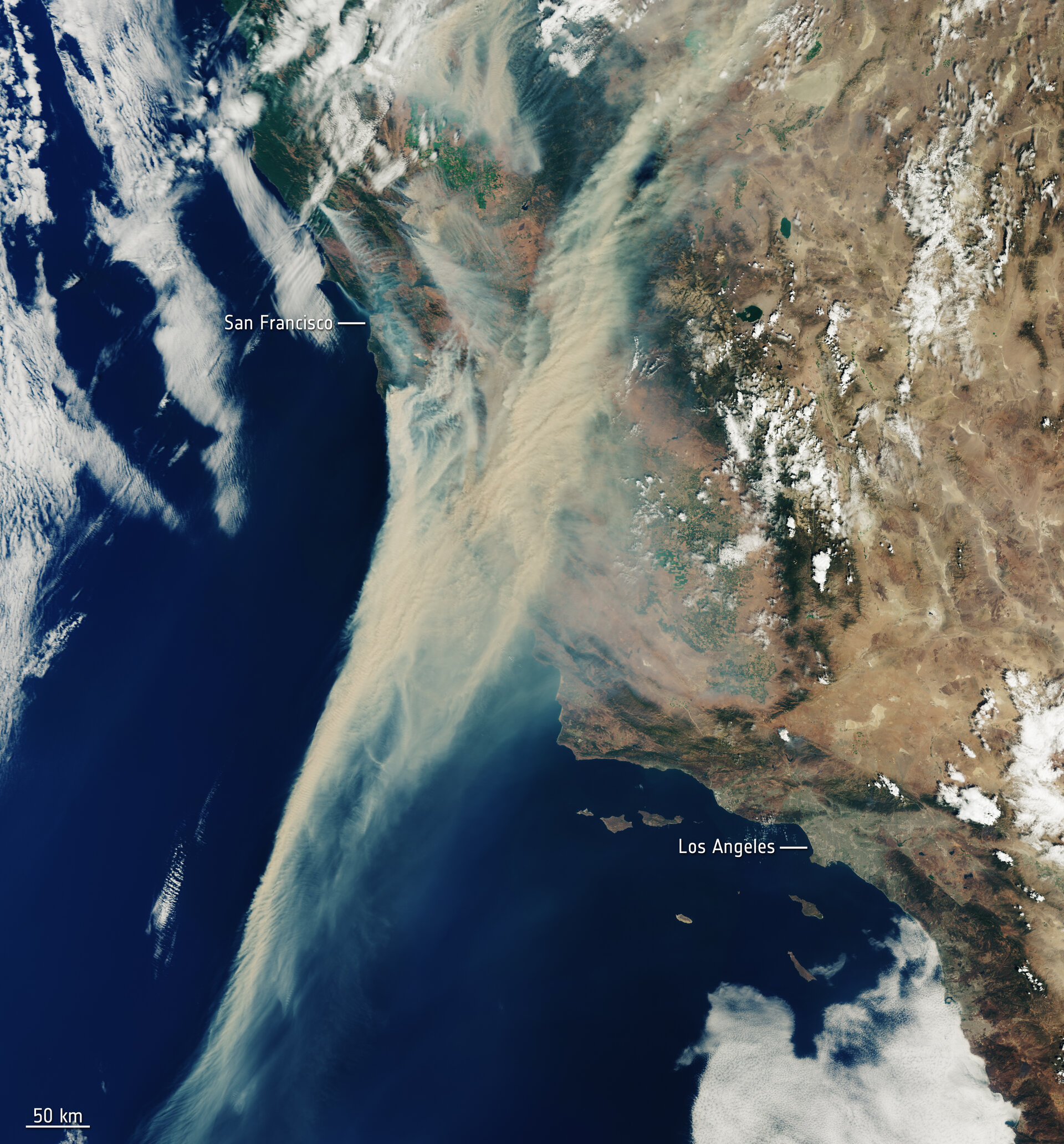
European spacecraft are also watching the fires blaze from space. For example, the Copernicus Sentinel-3 satellite, which is operated by the European Space Agency (ESA) and the European Organization for the Exploitation of Meteorological Satellites, has taken images that show the massive quantities of smoke trailing off the California coast.
As can be seen in the high-resolution image taken by Sentinel-3, the wildfires stretch across the state. In fact, according to the ESA, there are about 40 separate wildfires currently raging throughout California.
Email Chelsea Gohd at cgohd@space.com or follow her on Twitter @chelsea_gohd. Follow us on Twitter @Spacedotcom and on Facebook.
Join our Space Forums to keep talking space on the latest missions, night sky and more! And if you have a news tip, correction or comment, let us know at: community@space.com.

Chelsea “Foxanne” Gohd joined Space.com in 2018 and is now a Senior Writer, writing about everything from climate change to planetary science and human spaceflight in both articles and on-camera in videos. With a degree in Public Health and biological sciences, Chelsea has written and worked for institutions including the American Museum of Natural History, Scientific American, Discover Magazine Blog, Astronomy Magazine and Live Science. When not writing, editing or filming something space-y, Chelsea "Foxanne" Gohd is writing music and performing as Foxanne, even launching a song to space in 2021 with Inspiration4. You can follow her on Twitter @chelsea_gohd and @foxannemusic.

