Even Satellites Can See Europe's Sweltering Heat Wave
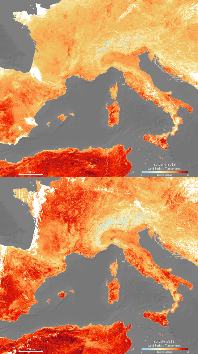
An image of Europe pulsing red shows the effects of a heat wave sweeping across the continent again in July, following extreme temperatures in June.
The image, based on data from the European Union's Copernicus program, represents high temperatures — particularly in the regions of the Netherlands, Belgium and Germany. Paris recently hit a peak of 105 degrees Fahrenheit (41 degrees Celsius), breaking a record set in 1947, according to a statement released by the European Space Agency.
The animation shows the warm temperatures on Thursday (July 25), compared with the peak of the previous heat wave on June 26, 2019. That weather event also broke records.
Related: Earth Day 2019: These Amazing NASA Images Show Earth from Above
The data displayed in the images was gathered by the Copernicus Sentinel-3's sea and land surface temperature radiometer, which measures the energy radiating from the Earth. That makes this approach a more accurate representation of land temperature than traditional weather forecasts that predict air temperatures, according to ESA.
eat is shown in shades of red; ice, such as in the Alps, in blue; the white patches are clouds.
In response to the current heat wave, many countries have issued warnings, recommending that residents drink lots of water and avoid traveling.
Get the Space.com Newsletter
Breaking space news, the latest updates on rocket launches, skywatching events and more!
The Earth does goes through natural cycles of warming and cooling, and individual weather events cannot typically be ascribed to climate change. But current warming trends and other climatic disruptions are driven by an unprecedented, human-caused increase in atmospheric concentrations in carbon dioxide, a greenhouse gas commonly released by vehicles and industrial activities. Today's warming has only taken about 150 years, compared to tens of thousands of years during a particularly fast warming period in the past known as the Paleo-Eocene Thermal Maximum.
- Climate Change Made Recent Hurricanes Wetter. And They May Get Worse.
- Astronaut's Rare Thunderstorm Photos from Space Reveal Stormy Science
- 4 Powerful Storms Seen from Space in 1 Day
Follow Elizabeth Howell on Twitter @howellspace. Follow us on Twitter @Spacedotcom and on Facebook.
Join our Space Forums to keep talking space on the latest missions, night sky and more! And if you have a news tip, correction or comment, let us know at: community@space.com.

Elizabeth Howell (she/her), Ph.D., was a staff writer in the spaceflight channel between 2022 and 2024 specializing in Canadian space news. She was contributing writer for Space.com for 10 years from 2012 to 2024. Elizabeth's reporting includes multiple exclusives with the White House, leading world coverage about a lost-and-found space tomato on the International Space Station, witnessing five human spaceflight launches on two continents, flying parabolic, working inside a spacesuit, and participating in a simulated Mars mission. Her latest book, "Why Am I Taller?" (ECW Press, 2022) is co-written with astronaut Dave Williams.
