Satellite spots glowing lava inside erupting Hawaiian volcano
Kilauea is erupting yet again.

Lava and smoke shine brightly in a fresh satellite image of an erupting Hawaiian volcano.
Kilauea, based on Hawaii's Big Island nearby the volcano Mauna Loa, has been erupting again since Jan. 5 and its fresh activity glows in a Landsat 8 satellite image taken on Jan. 11.
Activity extending from September 2021 to December 2022 already had created a lake of lava surrounding Kilauea, according to NASA's Earth Observatory. "Kilauea has erupted almost continuously from 1983 until 2018, when a months-long eruption created slow-moving lava flows that destroyed around 700 homes," NASA's Earth Observatory wrote in a statement Tuesday (Jan. 17).
"Since the 2018 eruption, Kilauea has been erupting sporadically," the observatory added. "These recent eruptions have been contained within the Halema'uma'u crater as lakes of lava."
Related: Space volcanoes: Origins, variants and eruptions
It appears that Kilauea and Mauna Loa have volcanic activity that influences the other caldera, even though the volcanoes don't share a connection, but that relationship is not firmly established yet.
"When Mauna Loa is frequently active, Kilauea tends to be less active, and vice versa," Jim Kauahikaua, a volcanologist with the Hawaiian Volcano Observatory, told the New York Times in November 2022.
Get the Space.com Newsletter
Breaking space news, the latest updates on rocket launches, skywatching events and more!
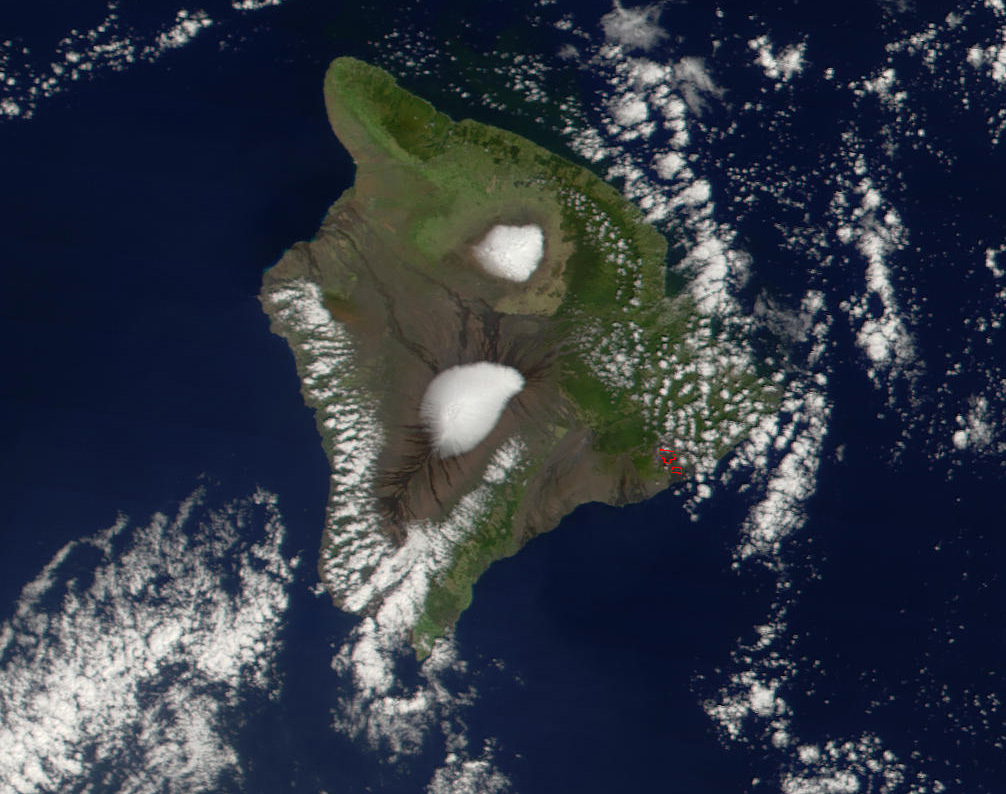
Lava bursts in Halema'uma'u crater have been reaching as high as 50 meters (164 feet) high amid the new outburst, especially in the hours after the eruption began on Jan. 5, NASA added.
Landsat 8's image with its Operational Land Imager instrument is a combination of natural color and, to better highlight the heat signature of the lava, infrared wavelengths. Most of the eruption during the imaging period Jan. 11 was in the eastern part of Halema'uma'u, NASA reported.
Elizabeth Howell is the co-author of "Why Am I Taller?" (ECW Press, 2022; with Canadian astronaut Dave Williams), a book about space medicine. Follow her on Twitter @howellspace. Follow us on Twitter @Spacedotcom or Facebook.
Join our Space Forums to keep talking space on the latest missions, night sky and more! And if you have a news tip, correction or comment, let us know at: community@space.com.

Elizabeth Howell (she/her), Ph.D., was a staff writer in the spaceflight channel between 2022 and 2024 specializing in Canadian space news. She was contributing writer for Space.com for 10 years from 2012 to 2024. Elizabeth's reporting includes multiple exclusives with the White House, leading world coverage about a lost-and-found space tomato on the International Space Station, witnessing five human spaceflight launches on two continents, flying parabolic, working inside a spacesuit, and participating in a simulated Mars mission. Her latest book, "Why Am I Taller?" (ECW Press, 2022) is co-written with astronaut Dave Williams.

