'Extremely Dangerous' Hurricane Dorian Is Now a Category 3 Storm
It's time to start preparing, if you haven't already.
Hurricane Dorian has strengthened to a Category 3 storm as of 2 p.m. EST on Friday (Aug. 3).
"Data from a reconnaissance plane indicate that... maximum sustained winds have increased to near 115 mph (185 km/h) with higher gusts," the National Hurricane Center (NHC) said in an update. "Additional strengthening is forecast, and Dorian is anticipated to remain an extremely dangerous major hurricane while it moves near the northwestern Bahamas and approaches the Florida peninsula into early next week."
The storm's westward movement is expected to slow down, and its core is now forecast to approach the northwestern Bahamas Sunday (Sept. 1) and eastern Florida late Monday (Sept. 2).
Related: Hurricane Season 2019: How Long It Lasts and What to Expect
Watch: Hurricane Dorian Seen from Space on Aug. 30
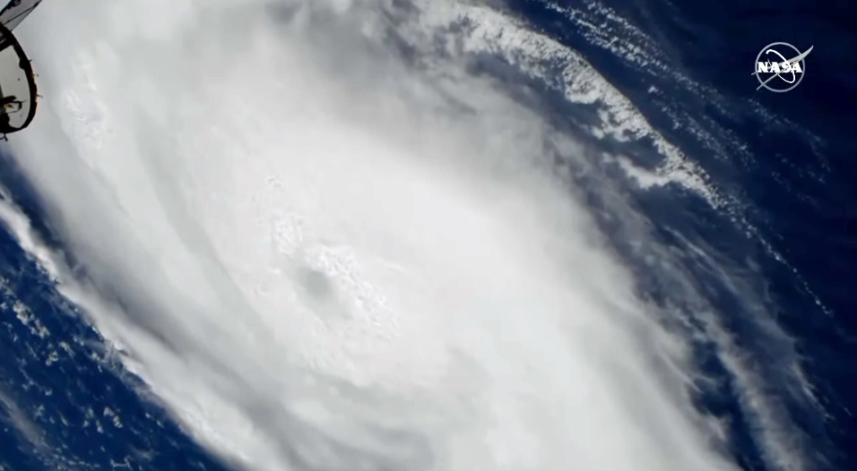
"A life-threatening storm surge will raise water levels by as much as 10 to 15 feet above normal tide levels in areas of onshore winds in the northwestern Bahamas. Near the coast, the surge will be accompanied by large and destructive waves," the NHC wrote.
Next week, significant rainfall is expected to blanket impacted regions of the United States, triggering flash floods. As much as 18 inches (45 centimeters) of rainfall could add to the dangers from the storm surge and powerful winds.
Get the Space.com Newsletter
Breaking space news, the latest updates on rocket launches, skywatching events and more!
The storm, which dealt Puerto Rico a comparatively mild blow Wednesday (Aug. 28), has since moved a couple hundred miles north. Dorian is tracking northwest toward Florida with maximum sustained winds of 85 mph (135 km/h), making it a Category 1 hurricane now.
However, the NHC said, pressure inside the hurricane has dropped significantly, which should drive the storm to strengthen into a "major hurricane" on Friday. Faster winds have likely not yet appeared, because a "double-eyewall" structure has emerged in the hurricane, temporarily limiting the most extreme winds.
Meteorologists with the NHC warned that Dorian poses a major threat to the northwestern Bahamas and the southeast coast of the United States over Labor Day weekend.
Here's how to prepare for the storm.
- Hurricanes from Above: Images of Nature's Biggest Storms
- Photos: Hurricane Michael Toppled Over Trees and Uprooted 19th Century Artifacts
- Inside Irma's Eye: Hurricane Hunters Capture Jaw-Dropping Photos
Originally published on Live Science.
Hurricane Dorian has strengthened to a Category 3 storm as of 2 p.m. EST on Friday (Aug. 3).
"Data from a reconnaissance plane indicate that... maximum sustained winds have increased to near 115 mph (185 km/h) with higher gusts," the National Hurricane Center (NHC) said in an update. "Additional strengthening is forecast, and Dorian is anticipated to remain an extremely dangerous major hurricane while it moves near the northwestern Bahamas and approaches the Florida peninsula into early next week."
The storm's westward movement is expected to slow down, and its core is now forecast to approach the northwestern Bahamas Sunday (Sept. 1) and eastern Florida late Monday (Sept. 2).
Related: Hurricane Season 2019: How Long It Lasts and What to Expect
"A life-threatening storm surge will raise water levels by as much as 10 to 15 feet above normal tide levels in areas of onshore winds in the northwestern Bahamas. Near the coast, the surge will be accompanied by large and destructive waves," the NHC wrote.
Next week, significant rainfall is expected to blanket impacted regions of the United States, triggering flash floods. As much as 18 inches (45 centimeters) of rainfall could add to the dangers from the storm surge and powerful winds.
The storm, which dealt Puerto Rico a comparatively mild blow Wednesday (Aug. 28), has since moved a couple hundred miles north. Dorian is tracking northwest toward Florida with maximum sustained winds of 85 mph (135 km/h), making it a Category 1 hurricane now. However, the NHC said, pressure inside the hurricane has dropped significantly, which should drive the storm to strengthen into a "major hurricane" on Friday. Faster winds have likely not yet appeared, because a "double-eyewall" structure has emerged in the hurricane, temporarily limiting the most extreme winds.
Meteorologists with the NHC warned that Dorian poses a major threat to the northwestern Bahamas and the southeast coast of the United States over Labor Day weekend.
Here's how to prepare for the storm.
- Hurricanes from Above: Images of Nature's Biggest Storms
- Photos: Hurricane Michael Toppled Over Trees and Uprooted 19th Century Artifacts
- Inside Irma's Eye: Hurricane Hunters Capture Jaw-Dropping Photos
Originally published on Live Science.
Join our Space Forums to keep talking space on the latest missions, night sky and more! And if you have a news tip, correction or comment, let us know at: community@space.com.

Rafi wrote for Live Science from 2017 until 2021, when he became a technical writer for IBM Quantum. He has a bachelor's degree in journalism from Northwestern University’s Medill School of journalism. You can find his past science reporting at Inverse, Business Insider and Popular Science, and his past photojournalism on the Flash90 wire service and in the pages of The Courier Post of southern New Jersey.


