As Hurricane Helene continues making its way toward Florida — now at Category 2 status — satellites in Earth orbit have been watching from above.
The GOES-16 spacecraft in particular, operated by NASA and the National Oceanic and Atmospheric Administration (NOAA), has delivered quite a bit of Helene footage, showing the storm gaining power while heading away from the Gulf of Mexico region and toward the southeastern U.S. "Sunrise on intense convection within an intensifying Hurricane Helene this morning," the Cooperative Institute for Research in the Atmosphere (CIRA) wrote in an X post (formerly Twitter) on Thursday morning (Sept. 26).
The storm, which NOAA calls potentially "life-threatening" due to wind speeds and projected levels of flooding, is expected to make landfall in Florida on Thursday evening. By that point, it is also estimated to significantly intensify beyond its current state. As of about 11:00 a.m. EDT (1500 GMT) on Thursday, the storm was approximately 255 miles (410 kilometers) southwest of Tampa, Florida, and tracking north-northeast at 14 mph (23 kph). Maximum sustained winds measured in at 105 mph (169 kph).
Sunrise on intense convection within an intensifying Hurricane Helene this morning. pic.twitter.com/FXyguxyiN3September 26, 2024
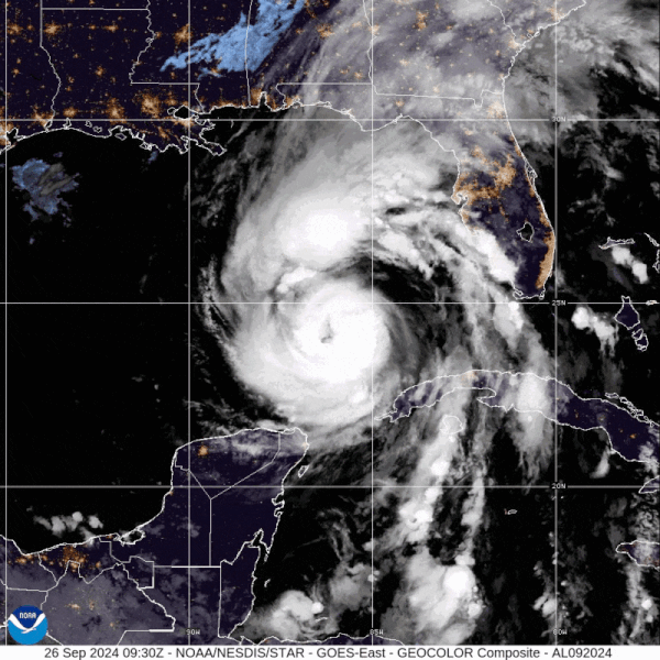
Previous GOES-16 satellite footage, collected when the storm was still mostly focused over the Gulf of Mexico, also offer clear indications of Helene's progressively increasing power. On NOAA's Helene-tracking page, composite imagery from the GOES-East satellite mirrors those results, showing the storm following its anticipated trajectory while growing stronger.
Related: Hurricane Helene could yield major flooding, tornadoes and 'devastating' winds, experts warn
Some previous GOES-16 imagery shows lightning spiraling in the storm's arms as well. Meanwhile, a sunrise-to-sunset time-lapse of the hurricane from Wednesday night (Sept. 25) shows it "bubbling, swirling, and slowly strengthening," CIRA wrote in a separate X post.
Mesmerizing imagery of Hurricane Helene today as lightning spirals in its outer bands. pic.twitter.com/GGty1GmniQSeptember 26, 2024
Another one of CIRA's X posts also highlights the way warm waters nurtured Hurricane Helene in the Gulf of Mexico: Heat maps reveal the sea surface temperatures of that body of water right around when Helene was about to approach. This is of note because, as experts have said time and again, climate change — primarily driven by human activities like burning coal for cheap power — fosters the right conditions for hurricanes to occur more often and with greater might.
For example, hurricanes grow in power as their arms hang on to moist air and shuffle that moist air inward. Industrial emissions pave the way for global warming, which means warmer air, and warmer air means that hurricanes can hold on to more water vapor.
And Helene passed over warm Gulf of Mexico waters, shown in the GOES-16 satellite's heat maps, on its way toward Florida. This is in part why it was able to gain so much power; experts are thus urging residents of the southeastern U.S. to brace for impact, following relevant instructions in their communities and evacuating if necessary.
Very warm waters await Hurricane Helene in the Gulf of Mexico as seen in this satellite imagery showing the sea surface temperatures of the body of water.Helene is forecast intensify into a major hurricane before making landfall in the Florida panhandle tomorrow evening. pic.twitter.com/Ryd6bnK8iQSeptember 25, 2024
An advisory put out by NOAA on Wednesday warns of serious flash floods in certain zones, depicted in the image below, as well as tornadoes and wind speeds greater than 80 mph (130 kph). "The mountainous terrain of the southern Appalachians will likely inundate communities in its path with flash floods, landslides, and cause extensive river and stream flooding," the organization said in an emailed statement to reporters on Wednesday (Sept. 25).
A Storm Surge Warning applies to areas in the U.S. as far inland as Indiana, but adjacent zones should also remain vigilant because hurricanes have the ability to spray out impacts far beyond their cores.

Power outages have already begun to occur in affected areas, including Georgia, Florida and even across the Carolinas.
Though scientists believe Helene will weaken after landfall in the U.S. occurs, they stress that strong and damaging winds will continue to penetrate through well after.
"NOAA's National Weather Service is alerting communities that Helene's flooding rainfall and high winds won't be limited to the Gulf Coast and are expected to travel hundreds of miles inland," the organization said in the emailed statement. "Helene is an unusually large storm, whose windfield extends as far as 275 miles [440 km] from its center ... The major flood risk includes the urban areas around Tallahassee, metro Atlanta and western North Carolina, including Asheville."
"Gusty winds, combined with saturated ground, will also raise the risk of falling trees that can cause loss of life, property damage, blocked roads, and lead to power outages," the statement reads.
Join our Space Forums to keep talking space on the latest missions, night sky and more! And if you have a news tip, correction or comment, let us know at: community@space.com.


