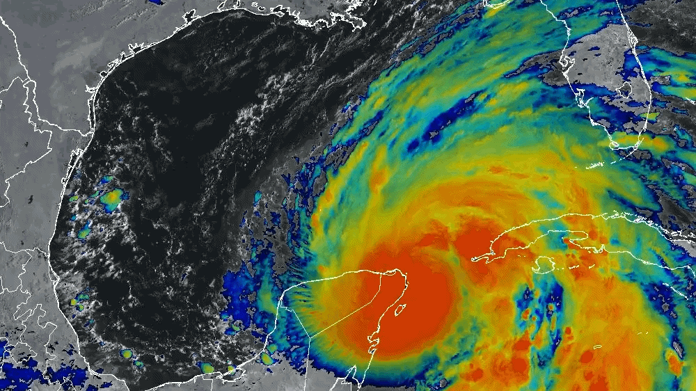
On Wednesday (Sept. 25), the U.S. National Hurricane Center (NHC) announced that Helene — a major storm currently inundating Mexico's Yucatan Peninsula and Western Cuba — has reached Category 1 hurricane status. Over the next day, Helene will head toward Florida's Gulf Coast.
Furthermore, the NHC projects that Helene will only increase in intensity before making landfall in Florida on Thursday (Sept. 26) evening — a path that, in fact, convinced NASA and SpaceX to delay the launch of the Crew-9 astronaut mission from Florida's Cape Canaveral Space Force Station, pushing it from Thursday to Saturday (Sept. 28).
The NHC warns that impacts of Helene have the potential to be "life-threatening." Those life-threatening conditions include possible flash and urban flooding this week in areas of northwestern and northern Florida as well as the U.S. Southeast in general, the southern Appalachians and the Upper Tennessee Valley. In some places, flooding could reach about 10 feet (3 meters) above ground level.
"Helene is expected to bring life-threatening storm surge, damaging winds and flooding rains to a large portion of Florida and the southeast U.S.," the NHC wrote in a post on X (formerly Twitter) on Wednesday. Accordingly, a Storm Surge Warning has been set in place along the entire Florida Peninsula and Florida Big Bend, the organization says, urging residents in those areas to follow their respective instructions and evacuate if necessary.
Related: Why is Earth's weather getting weirder?
Though the most extreme impacts are estimated to occur in affected coastal regions, the NHC emphasizes that its overall hurricane warning for Helene extends as far inland in the U.S. as the state of Indiana, where the storm could potentially be felt early on Friday (Sept. 27) and during the evening of Saturday.
"Devastating hurricane-force winds are expected across portions of northern Florida and southern Georgia where the core of Helene moves inland," the NHC writes in a Wednesday advisory about the storm. "Preparations to protect life and property should be completed by early Thursday since tropical storm conditions are expected to begin within these areas on Thursday."
Plus, experts are highlighting that a hurricane's core isn't the only part of its damaging anatomy; outer regions of the storm can also have significant effects on the land below. Thus, adjacent zones should keep vigilant as well.

A longer Wednesday advisory also suggests Helene could spur one or two tornadoes over parts of the Florida Peninsula and southern Alabama, with tornado risk as a whole increasing later on Thursday and expanding into areas of Georgia and South Carolina.
In terms of airborne dangers, maximum sustained winds from the hurricane presently sit around 80 mph (130 kph) — but that figure is expected to go up by the time Helene reaches Florida's Big Bend coast on Thursday evening. "Weakening is expected after landfall, but Helene's fast forward speed will allow strong, damaging winds, especially in gusts, to penetrate well inland across the southeastern United States," the advisory says.
Of note, such wind has the potential to directly knock down power lines, or knock down trees that could fall on power lines and force an indirect tumble. This means power outages across impacted regions of the U.S. are not out of the question in the coming days.
The 2024 hurricane season was rightfully predicted to be an active one; in July, Hurricane Beryl broke multiple records while making landfall three times in a week. To put this into perspective, hurricanes aren't expected to form until Aug. 11 or achieve Category 4 status until Sept. 1. Beryl even achieved Category 5.
Climate change, driven primarily by human activities like burning coal for cheap power, is also creating the right conditions for more intense and more frequent storms such as both Beryl and Helene.
"In a hurricane, spiraling winds draw moist air toward the center, fueling the towering thunderstorms that surround it," NASA explains, for example. "As the air continues to warm due to climate change, hurricanes can hold more water vapor, producing more intense rainfall rates in a storm."

