In the heart of the Gulf of Mexico, a new hurricane is brewing. Hurricane Milton, now having intensified into a Category 5 storm, was caught in incredible space-based imagery from spacecraft such as the U.S. National Oceanic and Atmospheric Administration's GOES-East satellite.
Hurricane Milton comes just ten days after Hurricane Helene, the deadliest hurricane to hit the United States since Katrina, made landfall in the southeastern U.S.
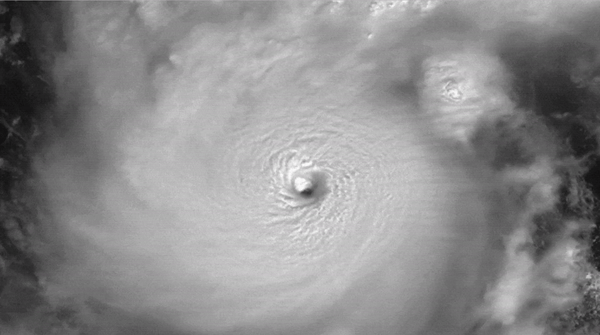
Milton poses a solid threat to the regions it will impact, and the National Hurricane Center is urging residents of Florida to take the storm extremely seriously. In satellite imagery, it is clear to see that Milton is intensifying. It jumped from a Category 1 to a Category 5 hurricane in mere hours on Monday (Oct. 7). That's the third swiftest intensification of a hurricane in the Atlantic, superseded only by Wilma in 2005 and Felix in 2007. Imagery captured from the International Space Station (ISS) also highlights the danger of the storm.
At 10:28 a.m. EDT October 7, the space station flew over Hurricane Milton and external cameras captured views of the category 5 storm, packing winds of 175 miles an hour, moving across the Gulf of Mexico toward the west coast of Florida. pic.twitter.com/MTtdUosiEcOctober 7, 2024

Milton also has what's called a "pinhole eye." This central, calm region is remarkably small — less than 10 nautical miles across. Storms with pinhole eyes tend to rapidly fluctuate in intensity.
Related: How satellite data has proven climate change is a climate crisis
A storm surge, along with heavy rain and winds, was expected to clip the top of the Yucatan Peninsula on Monday afternoon. Schools and ports in the Yucatan are closed in anticipation of the storm. Storm surges result when high winds from a hurricane start a vertical circulation of water. As this storm surge reaches the shallower waters of the coast, the shallow ocean floor pushes the water upwards.
Milton is then anticipated to make landfall on the western coast of Florida on Wednesday (Oct. 9) evening. Bands of rain and devastating winds will begin to pummel Florida long before this, however.
Reports from the National Hurricane Center enumerated many hazards of the storm.
Peak winds have already reached 175 miles per hour (282 kilometers per hour), and the hurricane itself will most likely grow in size between now and when it makes landfall in Florida. The west coast of Florida may see a storm surge of 8 to 12 feet (2.4 meters to 3.7 meters). Rain totals are forecasted to be between 5 to 10 inches (12.7 to 25.4 centimeters), and perhaps up to 15 in (38.1 cm) certain locations.
Some counties in #Florida have already ordered a mandatory #evacuation for when #HurricaneMilton hits the west coast. Be sure to know your zone at https://t.co/RL5vRfyB00 and to remain updated about the #hurricane got to https://t.co/0qJ2lutNUL#FL #Cat5https://t.co/ZaPkMk6bTNOctober 7, 2024
Residents of Florida are being urged to check the location of their house in relation to storm surge, rain and wind predictions as well as to evacuate if necessary. FloridaDisaster.org can help residents find their risk factors.
As Milton approaches, the southeastern U.S. is still recovering from the devastating Hurricane Helene. In a statement, Tracy Kijewski-Correa, an expert in disaster risk reduction, resilience, and sustainability at the University Notre Dame, said: "As the climate changes, we will have more extreme rainfall events. These storm events will exceed past precedent, making past experiences less relevant in deciding how to prepare and respond."
