Devastation wrought by Medicane Daniel revealed in satellite photos
Medicane Daniel, a rare Mediterranean storm, wreaked havoc on the usually arid north African nation of Libya.
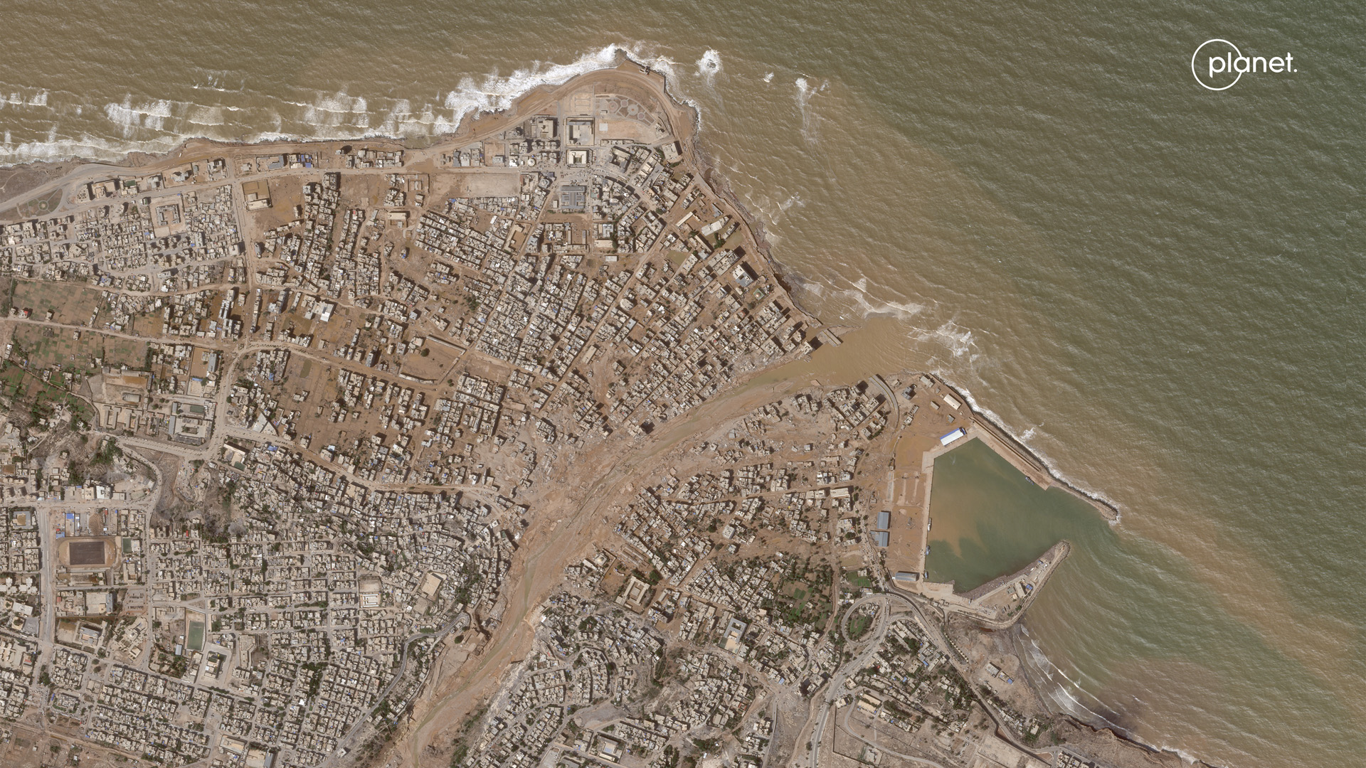
Satellite images reveal the scale of destruction wrought by medicane Daniel on Libya over the past several days. The visuals show temporary lakes and river systems across the desert landscape and reveal neighborhoods submerged by floodwater in the severely hit coastal city of Drrna.
Medicane Daniel, a rare hurricane-like storm that formed above the Mediterranean Sea last week, began its devastating rampage by dumping record-breaking amounts of rain on Greece, causing a catastrophic deluge. The storm then crossed the sea to Libya, in northern Africa.
Near the coastal city of Derna in Libya's northeast, several dams have reportedly burst under the strain of Daniel's torrential rains, unleashing huge amounts of water onto the city and causing extensive damage to buildings. More than 5,300 people have been confirmed dead due to flooding so far, according to Reuters, and thousands are still missing.
Since the storm clouds cleared, multiple satellites have managed to glimpse Libya, revealing the extent of the flooding and destruction it caused. In images taken by the European Earth-observing satellite Sentinel-2, temporary lakes and river systems are clearly seen stretching across normally parched Libyan terrain.
Related: 10 devastating signs of climate change satellites can see from space
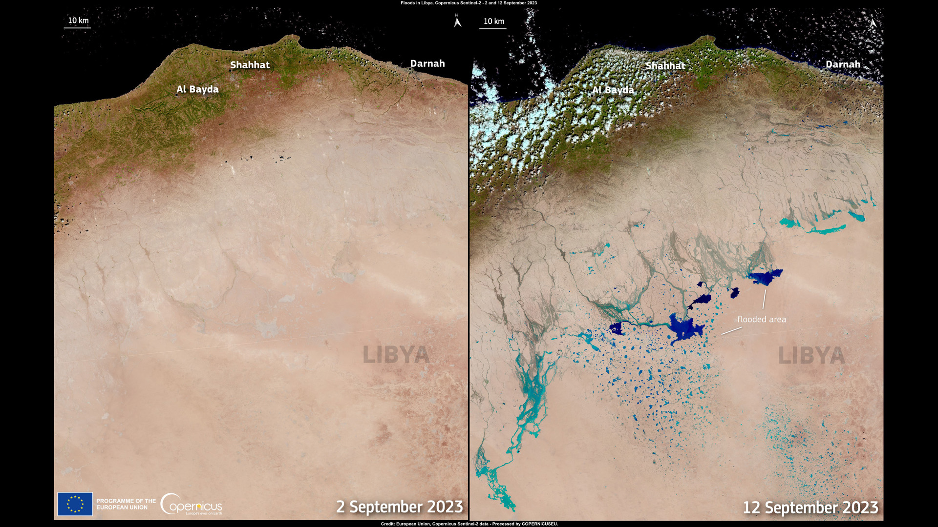
"These two images, acquired by one of the Copernicus Sentinel-2 satellites on 2 and 12 September, show the Libyan desert before and after the aftermath of Storm Daniel," the European environment-monitoring program Copernicus, which operates the Sentinel satellites, said in a statement. "The image on the left depicts the desert in its normal state, while the image on the right shows the flooded areas in cyan and blue tones."
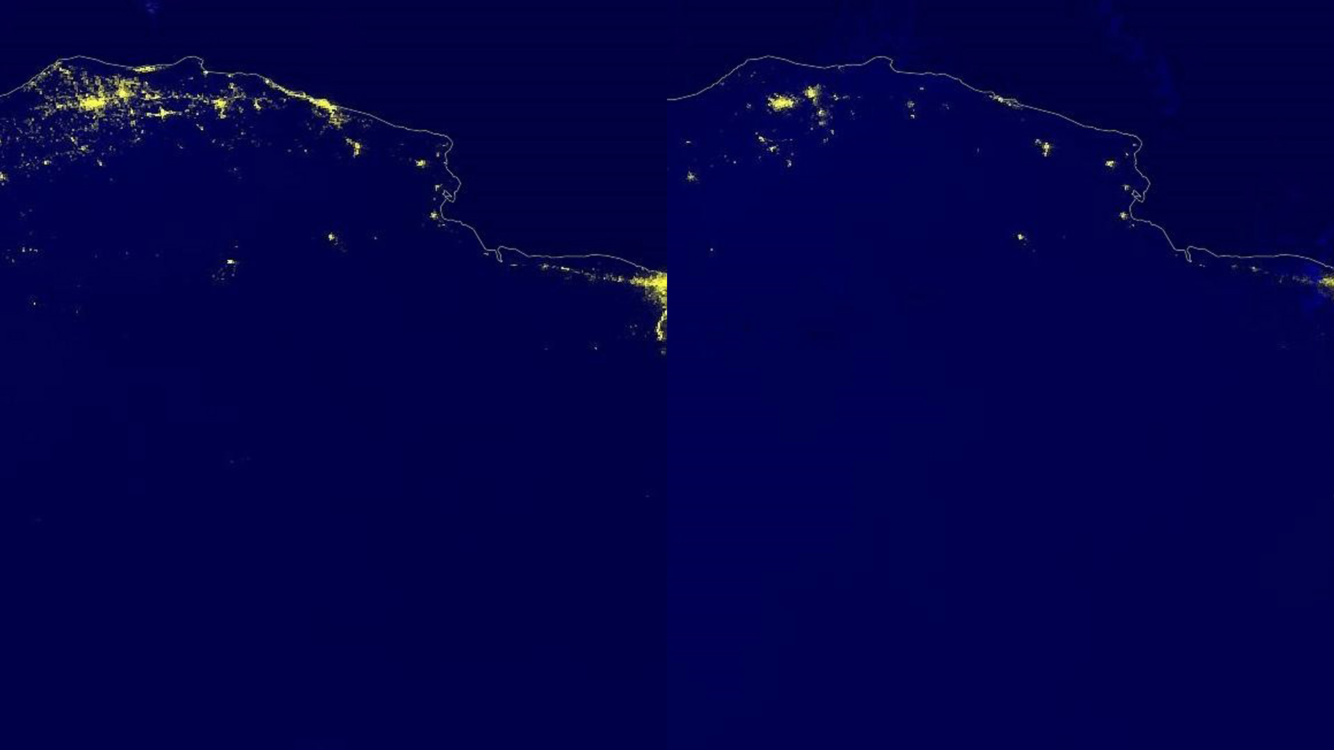
Night-time images obtained by U.S. National Oceanic and Atmospheric Administration (NOAA) spacecraft and processed by British Earth-observation researcher Simon Proud show the extent of power blackouts following the storm, in comparison with images taken before Daniel's passage.
Get the Space.com Newsletter
Breaking space news, the latest updates on rocket launches, skywatching events and more!
"In the aftermath of the horrific flooding in Libya, satellites are helping to map the scale of the human and physical destruction," Proud said in a post on X, sharing the images. "These two 'night lights' images from @NOAASatellites VIIRS [Visible Infrared Imaging Radiometer Suite] sensor show far fewer lights after the bad weather hit. Many areas without power now."
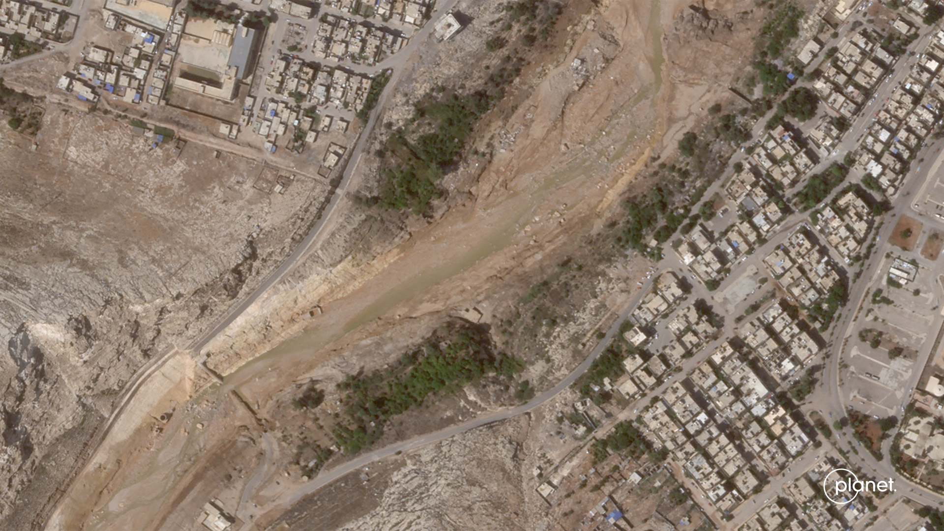
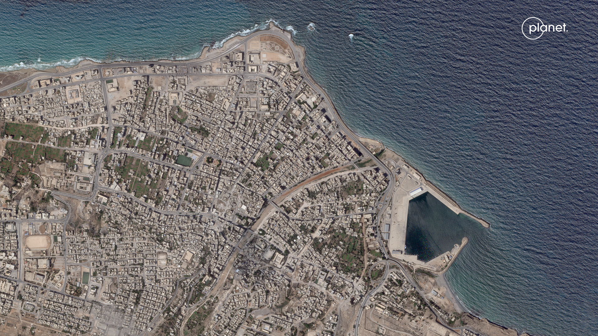
Satellites owned by U.S. Earth-observation company Planet provided a more detailed look at the ravaged Derna, where flooding from the collapsed dams dug a wide muddy trough through the city as the usually dried-out Wadi Derna river swelled far beyond its banks.
In the images taken in the wake of Storm Daniel, whole neighborhoods can be seen submerged in muddy water, bridges that once connected the river's two banks are missing and whole batches of houses along the river's banks have disappeared.
Medicanes, such as storm Daniel, are relatively rare, with only one to three forming on average every year, according to Reading University in the U.K. To see a medicane affect a Saharan country, such as Libya, however, is even more unusual, as these storms are known to more commonly strike the western part of the Mediterranean region, the university said in a statement. Data suggests that climate change may be decreasing the frequency of medicanes, but any that do form amid a warming Earth will likely be more powerful than they would be in an overall cooler climate.
Join our Space Forums to keep talking space on the latest missions, night sky and more! And if you have a news tip, correction or comment, let us know at: community@space.com.
Tereza is a London-based science and technology journalist, aspiring fiction writer and amateur gymnast. Originally from Prague, the Czech Republic, she spent the first seven years of her career working as a reporter, script-writer and presenter for various TV programmes of the Czech Public Service Television. She later took a career break to pursue further education and added a Master's in Science from the International Space University, France, to her Bachelor's in Journalism and Master's in Cultural Anthropology from Prague's Charles University. She worked as a reporter at the Engineering and Technology magazine, freelanced for a range of publications including Live Science, Space.com, Professional Engineering, Via Satellite and Space News and served as a maternity cover science editor at the European Space Agency.
