Satellites watch atmospheric river continue to drench California
Atmospheric rivers usually deliver up to 50% of California's annual precipitation.
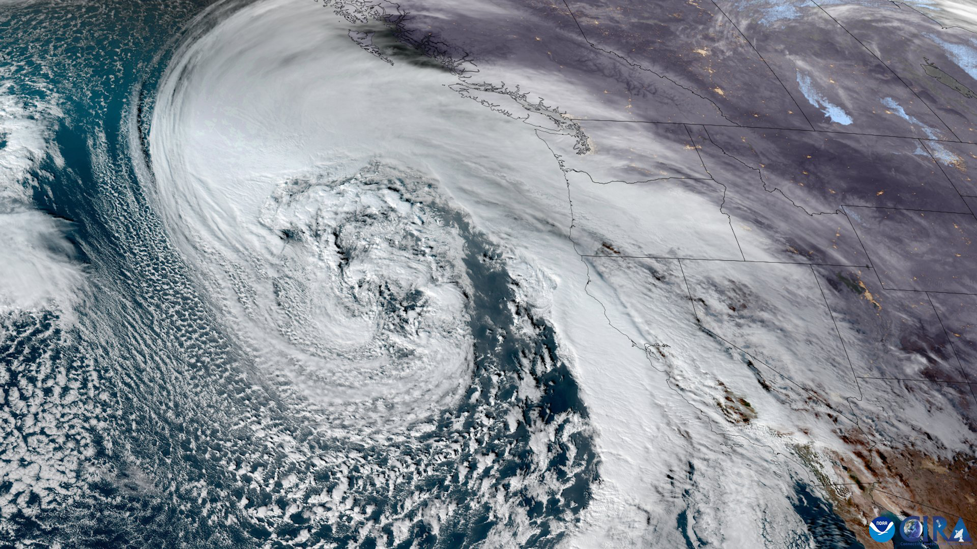
More rain is on its way to an already drenched California as forecasters observe two new "atmospheric rivers" form above the Pacific Ocean on their way to ship huge amounts of tropical moisture to the usually dry and sunny state.
After a superstorm dumped over 5 inches (12.7 centimeters) of rain in some coastal regions of California on Wednesday and Thursday (Jan. 4 and 5.), triggering flash floods and causing widespread power outages, Californians have received only a brief respite.
A new atmospheric river is expected to arrive Friday night, bringing more deluge to the coast and heavy snowfall to mountain regions.
"The cumulative effect of heavy rain after recent heavy rains will lead to additional considerable flood impacts this weekend, including rapid water rises and mudslides over northern and central California," the National Weather Service said in a tweet on Thursday, Jan. 5. "Flash flooding and debris flows are possible over burn scar areas [left by wildfires last summer]."
Related: Satellites watch Europe get hit by most severe winter heatwave ever
And that's not all that the current stormy weather has in store for California. The NWS said another atmospheric river is expected to arrive on Monday (Jan. 9), bringing more rain and strong winds.
This stormy January comes after above average rainfall in December, which saw over 11.6 inches (29 cm) of rain in San Francisco, according to the Washington Post, which is more than twice the average amount for that part of the year.
Get the Space.com Newsletter
Breaking space news, the latest updates on rocket launches, skywatching events and more!
Most of the moisture causing the deluges is being channeled from Hawai'i by so-called atmospheric rivers, channels that form in Earth's atmosphere and funnel water vapor from humid tropical regions to drier areas farther away from the equator.
The type of atmospheric river ravaging California is sometimes referred to as the Pineapple Express in a nod to the fruit commonly grown in Hawai'i.
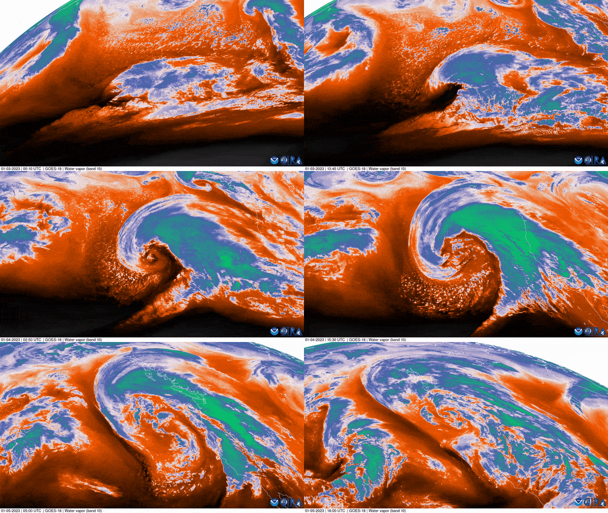
According to NASA, atmospheric rivers off California's coast form regularly during winter months and usually deliver up to 50% of the region's annual rain and snow.
The current series of atmospheric rivers is, however, particularly treacherous due to their combination with a pronounced area of low pressure, which led to the formation of an extremely powerful storm meteorologists call a bomb cyclone, such as the one that battered the area on Wednesday.
Follow Tereza Pultarova on Twitter @TerezaPultarova. Follow us on Twitter @Spacedotcom and on Facebook.
Join our Space Forums to keep talking space on the latest missions, night sky and more! And if you have a news tip, correction or comment, let us know at: community@space.com.

Tereza is a London-based science and technology journalist, aspiring fiction writer and amateur gymnast. Originally from Prague, the Czech Republic, she spent the first seven years of her career working as a reporter, script-writer and presenter for various TV programmes of the Czech Public Service Television. She later took a career break to pursue further education and added a Master's in Science from the International Space University, France, to her Bachelor's in Journalism and Master's in Cultural Anthropology from Prague's Charles University. She worked as a reporter at the Engineering and Technology magazine, freelanced for a range of publications including Live Science, Space.com, Professional Engineering, Via Satellite and Space News and served as a maternity cover science editor at the European Space Agency.
