Mount Etna's fiery eruptions seen from space (satellite photos)
Thar she blows!
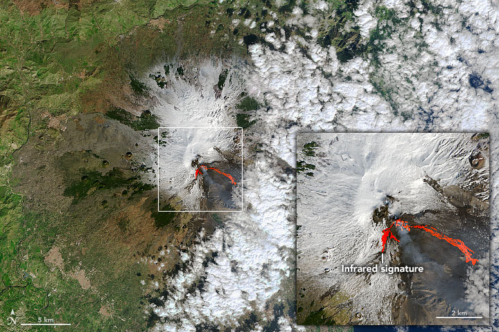
Mount Etna has been spewing lava across Sicily for weeks during a series of eruptions captured by a slew of Earth-orbiting satellites.
Etna, the most active volcano in all of Europe, has been in a state of eruption since 2011. The latest series began on Feb. 16. The volcano erupted that day, again on Feb. 18 and then again between Feb. 20 and 23. During these eruptions, fountains of lava shot high into the night sky, reaching 0.4 miles (0.7 kilometers) high earlier in the month and getting 0.9 miles (1.5 km) over the volcano's summit later in the month.
These most recent eruptions "were among the most violent in the Southeast Crater's young history," Marco Neri, a volcanologist with Italy's National Institute of Geophysics and Volcanology, said in a NASA statement.
Related: Asteroid impact, not volcanic activity, killed the dinosaurs
Earth-observing satellites were keen to check out the smoke, ash and lava flung out by the volcano. On Feb. 18, the Operational Land Imager (OLI) on the NASA-U.S. Geological Survey Landsat 8 satellite snapped a natural color view of the volcano, which was overlaid with infrared data to show the warm areas (or spots where lava had broken through).
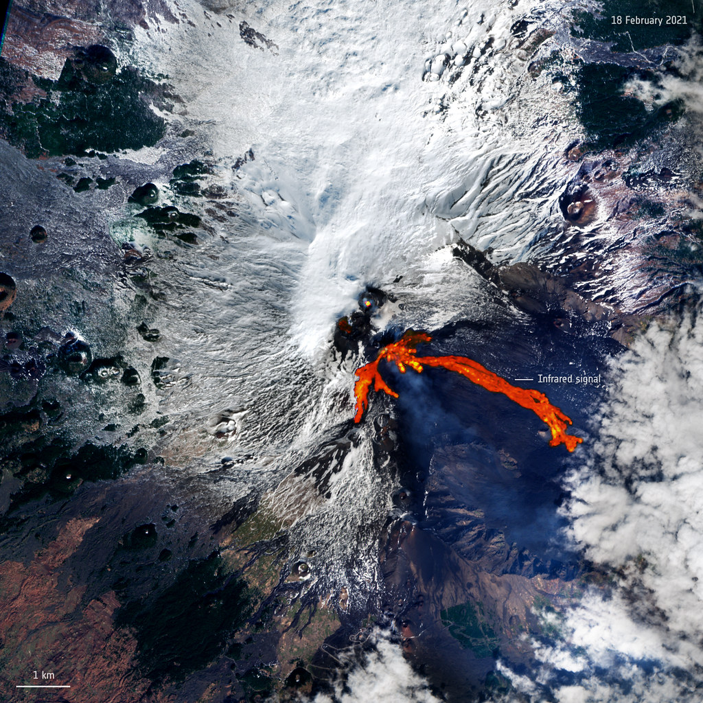
Also on Feb. 18, the European Space Agency's Copernicus Sentinel-2 mission, which is made up of two satellites, observed the eruption. The European satellites captured a moment that, using infrared imaging, showed the lava in bright orange and red.

A few days later, as Etna was erupting again on Feb. 23, the U.S. National Oceanic and Atmospheric Administration's NOAA-20 satellite snapped an image with its VIIRS (Visible Infrared Imaging Radiometer Suite) instrument that highlights the plumes coming from the volcano.
Get the Space.com Newsletter
Breaking space news, the latest updates on rocket launches, skywatching events and more!
Landsat 8 captured a nighttime image of activity at #MtEtna on Feb 25, 2021. This image uses the thermal and shortwave infrared bands (Bands 10, 7, 6) to show the heat signature of the lava. pic.twitter.com/ryTDbKw0nAMarch 1, 2021
Landsat 8 observed the volcano again on Feb. 25, this time at night. Using thermal and shortwave infrared bands, it was able to show the lava down below based on the heat coming off of it.
While these recent eruptions were impressive, they caused minor disruptions rather than major damage to the surrounding area, according to the NASA statement. Ash coming from Etna temporarily closed the Catania Airport and was deposited across Sicily, for example, and local residents had to deal with falling ash and rocks.
Email Chelsea Gohd at cgohd@space.com or follow her on Twitter @chelsea_gohd. Follow us on Twitter @Spacedotcom and on Facebook.
Join our Space Forums to keep talking space on the latest missions, night sky and more! And if you have a news tip, correction or comment, let us know at: community@space.com.

Chelsea “Foxanne” Gohd joined Space.com in 2018 and is now a Senior Writer, writing about everything from climate change to planetary science and human spaceflight in both articles and on-camera in videos. With a degree in Public Health and biological sciences, Chelsea has written and worked for institutions including the American Museum of Natural History, Scientific American, Discover Magazine Blog, Astronomy Magazine and Live Science. When not writing, editing or filming something space-y, Chelsea "Foxanne" Gohd is writing music and performing as Foxanne, even launching a song to space in 2021 with Inspiration4. You can follow her on Twitter @chelsea_gohd and @foxannemusic.

