This epic NASA map shows where to see US solar eclipses in 2023 and 2024 (photos)
Find out where and when to see the annular solar eclipse on Oct. 14, 2023 and the total solar eclipse on Apr. 8, 2024 with this useful NASA map.
Skywatchers in the United States looking to observe the upcoming solar eclipses will benefit from this detailed NASA solar eclipse map.
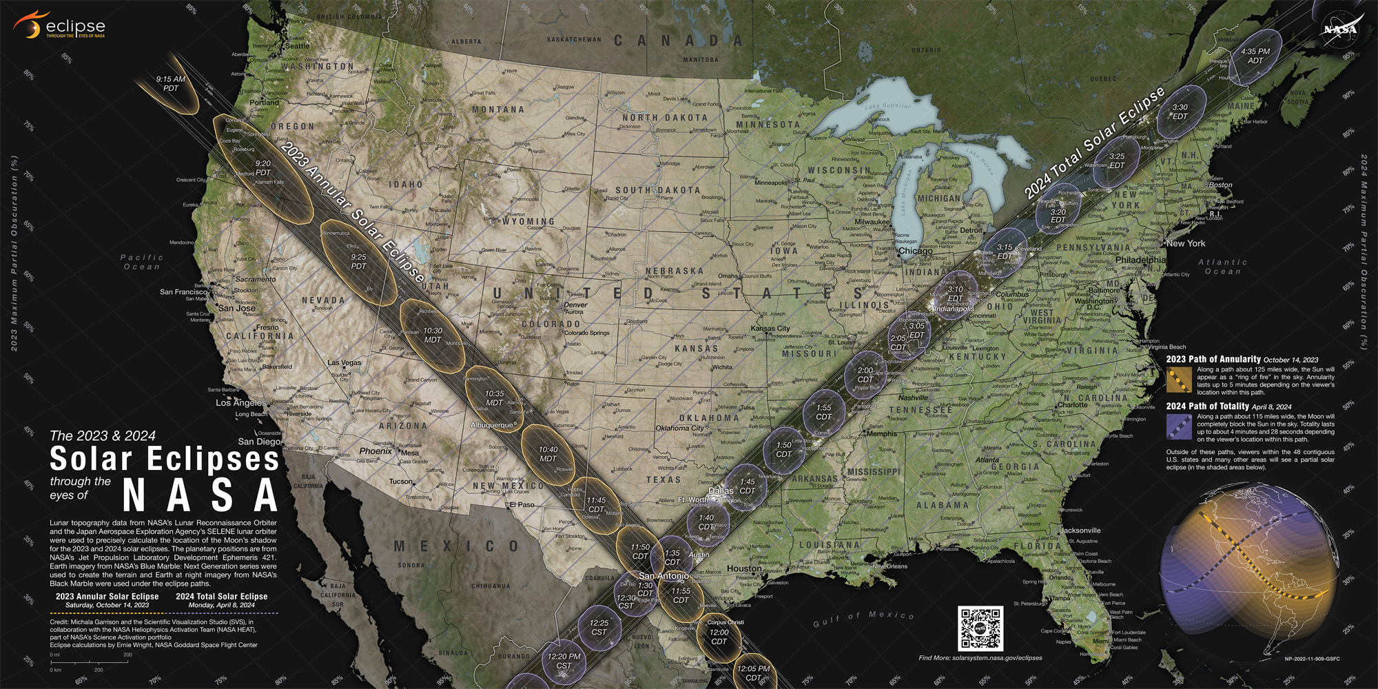
Based on data collected by several NASA missions the map shows the moon's shadow as it will cross the U.S. during the annular "ring of fire" solar eclipse on Oct. 14, 2023, and the total solar eclipse on April 8, 2024.
The solar eclipse map was designed by a member of NASA's Goddard Space Flight Center's Scientific Visualization Studio (SVS), Michala Garrison, who has a background in geography and cartography.
Related: How to read and understand a solar eclipse map
The goal of the map is to inspire people to view the eclipses and ensures they have access to details of annular and total eclipses. (You can download a super-high-resolution version from NASA's website.) Garrison didn't do last time the moon's shadow passed over the continental U.S. during what is often referred to as the "Great American Eclipse."
Related: Solar eclipses 2023: When and where to see the next solar eclipse
"In 2017, I was in Maryland, so I still got to see a little bit, because I was in a partial eclipse," Garrison said in a statement. "But I didn't really know any of this back then. This does make me want to go to, say, Albuquerque in 2023. And then in 2024 to go more south.'"
Get the Space.com Newsletter
Breaking space news, the latest updates on rocket launches, skywatching events and more!
The dark paths of the map show the locations in the U.S. where observers will need to be if they intend to view these eclipses and the sun as a blazing ring of fire. This white ring is the outer atmosphere of the sun, the corona, which is usually not visible without the aid of a special tool.
Related: 10 best events across the US to celebrate the Oct. 14 annular solar eclipse
This is because, despite the fact that the corona is mysteriously hotter than the surface of the sun known as the photosphere below it, something that flies in the face of stellar modeling that suggests stars should be hotter closer to the core, light from the photosphere "washes out" light from the corona. During eclipses, the photosphere is blocked by the moon meaning the light from the wispy and nebulous corona can be seen.
Outside the dark paths, the map displays areas where partial eclipses will be visible and how much of the sun will be covered by the moon. Both during the annular solar eclipse of 2023 and the total eclipse of 2024 all 48 contiguous states of the U.S. — the lower 48 states on the North American continent — will see at least a partial eclipse. Skywatchers in parts of Mexico and most of Canada will also get to see the eclipses of 2023 and 2024.
Related: Road trip! Catch October's annular solar eclipse with 5 iconic routes through the US
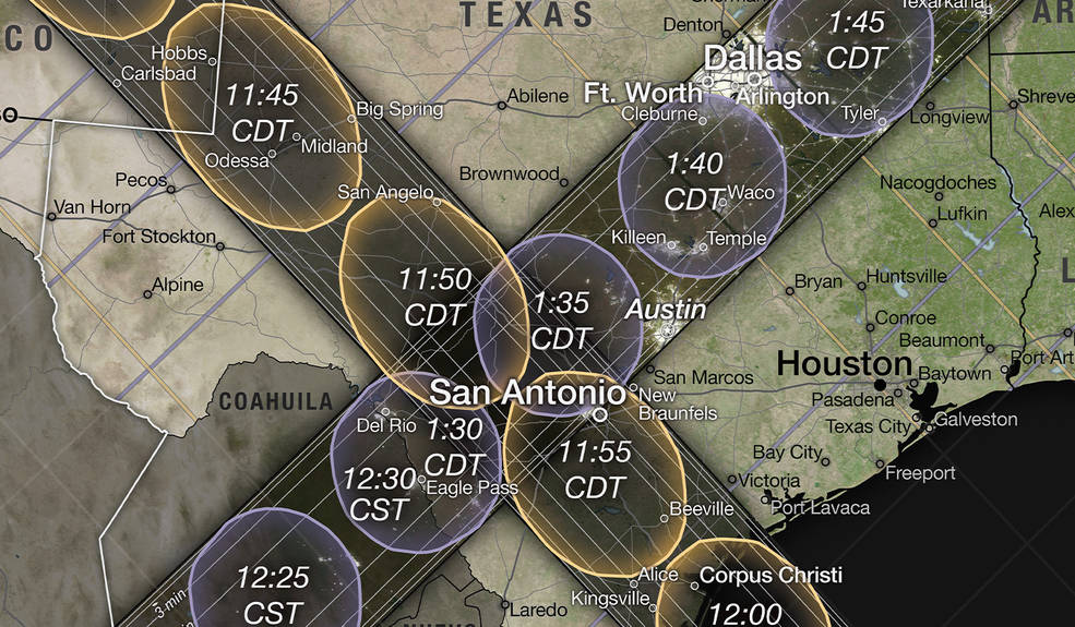
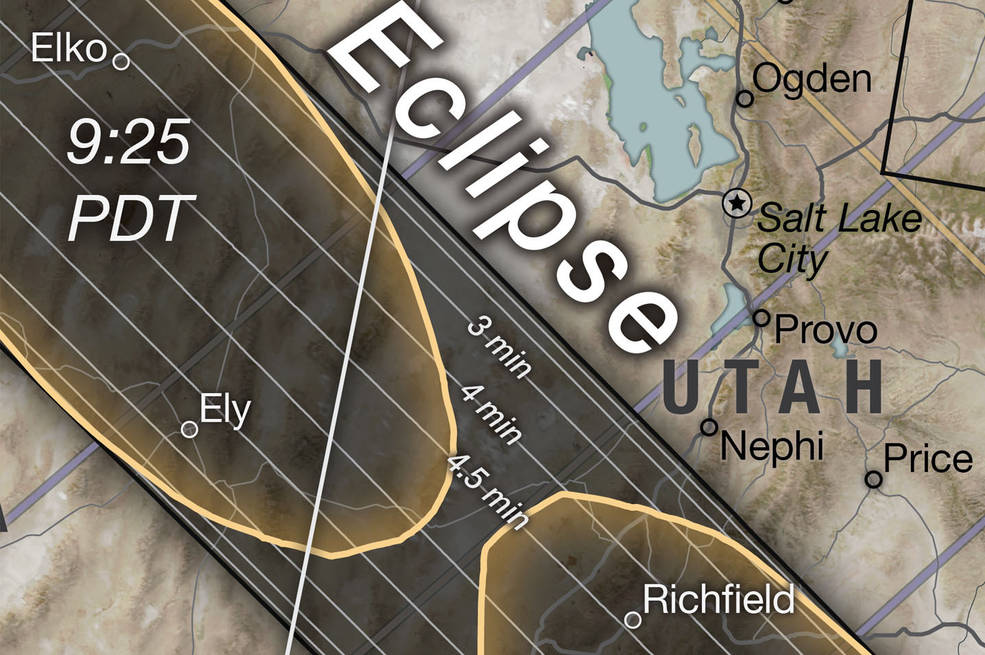
NASA's eclipse map shows the black and orange colored path of the moon's shadow from Oregon to Texas where the annular eclipse will be visible given favorable weather conditions. The black and purple path running from Texas to Maine represents the eclipse path during the April 2024 total eclipse.
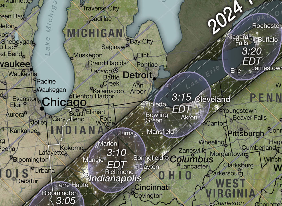
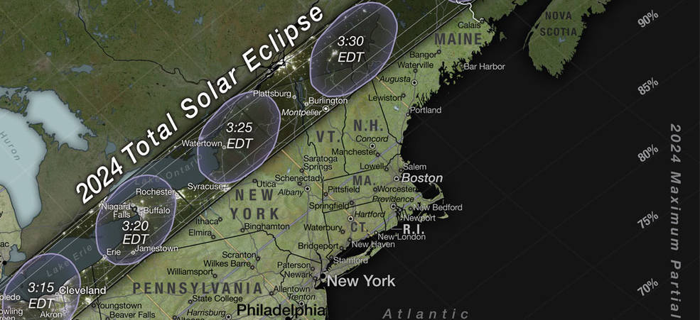
Within both paths are oval shapes that contain time stamps with the shape of these ovals showing the shape of the moon's shadow on Earth's surface at this time. The timestamp also represents the time that viewers in these locations will see the eclipse.
So for instance, observers in Akron and Cleveland will see the moon's shadow as a squashed circle when they view the 2024 total eclipse at 3:15 p.m. (EDT) on April 8, 2024. By 3:20 p.m. (EDT) on the same day according to the map, it will be the turn of observers in Rochester, Buffalo, and Niagara Falls to see the total eclipse.
These moon shadow shapes and the times they meet these locations were calculated using data regarding the moon's shape from the Lunar Reconnaissance Orbiter combined with information regarding the positions of the sun, moon, and Earth generated using software and data from NASA's Navigation and Ancillary Information Facility.
The eclipse map also shows lanes within the dark paths marked with time durations. These show how long the eclipses will last in these respective locations, and also demonstrate that observers in lanes closer to the center of the paths will experience the eclipses for longer.
Outside the dark paths, the map shows purple and orange lines running parallel to the eclipse paths. These indicate areas in which partial eclipses will be visible. The lines correspond with percentage labels at the edge of the map that show how much of the sun will be eclipsed as viewed from this area. Again the purple color represents the total eclipse of 2024 while orange marks the 2023 annular eclipse.
Related: Watch the moon's shadow travel across North America during 2024's total solar eclipse (video)
The eclipses of 2023 and 2024 won't be restricted to the contiguous U.S. so fittingly neither is the map. In the bottom right corner, the paths of the two eclipses across the globe can be seen. Earth elevation information data for the global model came from the Shuttle Radar Topography Mission.
This shows the black-and-orange path of the annular eclipse in 2023 running through Mexico, Central America, and South America. The map also shows the black-and-purple path of the total eclipse in 2024 extending through Mexico and northeastern Canada.
Additionally shaded areas across the global map show where partial eclipses can be seen. As examples, the shaded region indicates southeastern Alaska will see a partial eclipse in October 2023 and Hawaii will experience a partial eclipse in April 2024.
The map went through a series of revisions to ensure not only does it contain a wealth of information, but that it is aesthetically pleasing too.
This was aided by color for the land being provided by a mosaic of satellite images of Earth known as Blue Marble and created by the NASA Earth Observatory team. Added to this for the path of the 2024 total eclipse were nightside Earth images showing city lights provided by NASA’s Black Marble using data from the Suomi NPP spacecraft.
"It took a lot of trial and error. I wanted it to be useful to the reader but not overwhelming — and still be a pretty product to look at to catch people's eye," Garrison said.
Follow us @Spacedotcom on Twitter, or on Facebook and Instagram.
Join our Space Forums to keep talking space on the latest missions, night sky and more! And if you have a news tip, correction or comment, let us know at: community@space.com.

Robert Lea is a science journalist in the U.K. whose articles have been published in Physics World, New Scientist, Astronomy Magazine, All About Space, Newsweek and ZME Science. He also writes about science communication for Elsevier and the European Journal of Physics. Rob holds a bachelor of science degree in physics and astronomy from the U.K.’s Open University. Follow him on Twitter @sciencef1rst.
