Satellites map Earth's ocean floors in unprecedented detail

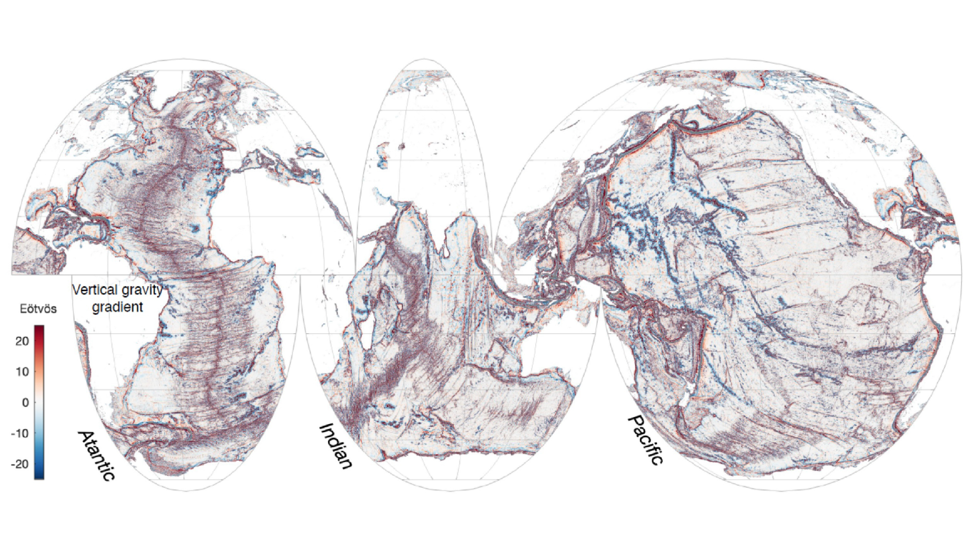
A map of the ocean seafloor
In its first year of operation, the SWOT satellite captured more details of the sea floor than in 30 years of data collected by older satellites. (Image credit: NASA/SWOT)

A new satellite has mapped Earth's ocean floors in unprecedented detail, a new study reveals. .

The first year of measurements from NASA's Surface Water and Ocean Topography (SWOT) satellite mission, launched in December 2022 and developed by NASA and France’s Centre National D’Etudes Spatiales, enabled researchers to study the boundaries between continents and identify underwater hills and volcanoes that are too small to be detected by earlier satellites.

"Finding these features will really push scientific developments forward, including tectonic theories," study co-author Yao Yu, a physical geographer at Scripps Institution of Oceanography, told Live Science. The findings could provide new information about ocean currents, nutrient transport in seawater and the geologic history of Earth's oceans.

With a 5-mile (8 kilometers) resolution and 21-day path covering most of the planet, just one year of data from SWOT gives a clearer picture of the ocean floor than 30 years of data collectively gathered by ships and older satellites, researchers said Dec. 12 in the journal Science.

To spot underwater features, SWOT measures the height of the ocean surface. Despite appearances, that surface is not flat, Yu said. The gravitational pull of underwater structures like hills and volcanoes causes water to pile atop those structures in spread-out lumps. Changes in the sea surface height therefore point to what lies deep beneath the surface.

The team focused on three types of underwater features: abyssal hills, small seamounts and continental margins. Abyssal hills — parallel ridges that are just hundreds of feet tall — are formed by the movements of tectonic plates. Using SWOT data, the team mapped individual hills and spotted a few places where the direction of the ridges changed, suggesting that at some point in Earth's history, the tectonic plate that formed them changed the direction of its movement.

"I'm very surprised by the abyssal hills,” Yu said, because the researchers weren’t expecting to see so many hills in so little time.

Yu and her colleagues also studied seamounts, or underwater volcanoes, which affect ocean currents and often act as hotspots for biodiversity. Older satellites have mapped large seamounts, but the team spotted thousands of smaller, previously unknown seamounts less than 3,300 feet (1,000 meters) tall in the SWOT data.

The data helped the team further refine maps of tectonic boundaries and ocean currents near coastal areas. "We're very interested in [continental margins] because the ocean currents and tides will bring nutrients and sediments from the land to the ocean and influence the biodiversity and ecology in the coastal area," Yu said.

In the remainder of its planned three-year science mission, SWOT will continue to collect data on ocean currents, map the ocean floor and assess global freshwater availability throughout the year.

Join our Space Forums to keep talking space on the latest missions, night sky and more! And if you have a news tip, correction or comment, let us know at: community@space.com.

Skyler Ware
Live Science Contributor

Skyler Ware is a freelance science journalist covering chemistry, biology, paleontology and Earth science. She was a 2023 AAAS Mass Media Science & Engineering Fellow at Science News. Her work has also appeared in Science News Explores, ZME Science and Chembites, among others. Skyler has a Ph.D. in chemistry from Caltech.

  • Unclear Engineer
    The title of this article seems totally disconnected from the article text.

    Working with the actual text, the article is really about the satellite data on the level variations of the ocean surface. From that data, there is a lot of inference made about level variations in the ocean floor. But, there is also acknowledgement that the surface level variation is influenced by currents. I would add that it is also influenced by variations in prevailing winds.

    So, it is not clear what degree of certainty is provided by this data set for the inferences of the bottom contours. I suspect it is not very certain, and would best be thought of as a reason to go to some places to do actual soundings.

    That said, looking at the data for the ocean surface that has a direct influence on the water levels where I live, I noted a lot of red, which means elevated ocean water surface. That seems to be associated with the Gulf Stream, so is not unexpected.

    However, by looking at the actual data on water levels where I live, it is clear that more than local winds play a substantial role in the net level. I have long suspected that the variations in the off shore ocean surface are important to the net level here. The Gulf Stream has a lot of eddies and swirls. The resulting motions in different directions should affect the water surface level from the east side of the Stream to the west side due to the Coriolis Effect. So, as the eddies and swirls go by (on a many month time period) the net level of the ocean on the coast here should change by some amount.

    I would be interested in seeing a graphic of the sea level off the east coast of the U.S. over a time period of approximately 3 years, to see if I can correlate the effects I have seen here with eddies in the Gulf Stream.

    BTW, this article does not even mention hydrogen.
    Reply
  • skel
    Unclear Engineer said:
    The title of this article seems totally disconnected from the article text.

    Working with the actual text, the article is really about the satellite data on the level variations of the ocean surface. From that data, there is a lot of inference made about level variations in the ocean floor. But, there is also acknowledgement that the surface level variation is influenced by currents. I would add that it is also influenced by variations in prevailing winds.

    So, it is not clear what degree of certainty is provided by this data set for the inferences of the bottom contours. I suspect it is not very certain, and would best be thought of as a reason to go to some places to do actual soundings.

    That said, looking at the data for the ocean surface that has a direct influence on the water levels where I live, I noted a lot of red, which means elevated ocean water surface. That seems to be associated with the Gulf Stream, so is not unexpected.

    However, by looking at the actual data on water levels where I live, it is clear that more than local winds play a substantial role in the net level. I have long suspected that the variations in the off shore ocean surface are important to the net level here. The Gulf Stream has a lot of eddies and swirls. The resulting motions in different directions should affect the water surface level from the east side of the Stream to the west side due to the Coriolis Effect. So, as the eddies and swirls go by (on a many month time period) the net level of the ocean on the coast here should change by some amount.

    I would be interested in seeing a graphic of the sea level off the east coast of the U.S. over a time period of approximately 3 years, to see if I can correlate the effects I have seen here with eddies in the Gulf Stream.

    BTW, this article does not even mention hydrogen.
    I was suspicious when the title had in the text. I searched the web using some of the text in the article and it revealed many copies of the same article. This is just a copied and reposted article. I will be blocking space.com from this point on. By the way, the title in one of the articles this text was taken from made more sense "Satellites reveal stunningly detailed maps of Earth’s seafloors – December 13, 2024"
    Reply
  • Unclear Engineer
    I am getting suspicious that the "editors" of Space.com are now some sort of AI algorithm instead of real people with common sense.

    That is becoming a major issue with science journals. For instance, see https://arstechnica.com/science/2024/12/journal-editors-resign-to-protest-ai-use-high-fees-and-more/ . The linked article says that is the 20th mass editorial resignation from science journals since 2023!
    It also says:
    "AI processing continues to be used and regularly reformats submitted manuscripts to change meaning and formatting and require extensive author and editor oversight during proof stage.”

    Apparently, copy editors are the first positions being eliminated by publishers, and those are the ones who are responsible for catching such errors.

    As the publishing business gets to be more and more driven by the goal of making profits for investors instead of providing professional level communication for scientists and engineers, I think we will be seeing not just more such errors, but also a steady decline in the competence and credibility of the articles and a steady increase in the "click bait" nature of the headlines.

    As the linked article states, these departures are starting to move past the mass protest stage, with some efforts now going into "establishing new independent nonprofit journals for the academic community that are open access and have high academic standards."

    Sad, but I think most of the journals previously considered to be the "gold standards" are already doomed at this point. It will be interesting to see if Internet-based non-profit replacements can actually achieve "high academic standards". It will require a lot of hands-on work by real people with motivation to achieve that scientific excellence.

    That may turn out to require a lot of dedicated volunteerism to achieve. From what I was told, the moderators here on Space.com are already volunteers. And, some of the other subject focused forums I use are completely run by volunteers, with someone who has the funds and the will paying for the Internet web hosting overhead costs.
    Reply
  • Classical Motion
    It's gonna get lots worse.

    Can A.I. say that? I wonder if A.I. could imitate me?

    If A.I. is now running some of these sites, then A.I. might be commenting too.
    Reply
  • COLGeek
    AI certainly does post on internet forums via bots. We occasionally catch and remove them. Not unusual at all.
    Reply