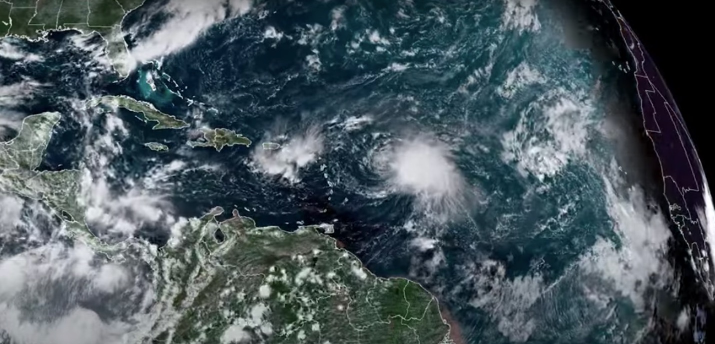
Weather satellites watch Tropical Storm Fiona develop in the Atlantic (video)
Fiona is progressing toward Puerto Rico and could eventually become a hurricane.
Weather satellites continue to observe Tropical Storm Fiona as it builds over the Atlantic Ocean.
Infrared data collected from Earth orbit is being used to track the progress of the storm and its qualities, such as thunderstorm activity, wind circulation patterns and showers.
Satellites have also picked up signs that the storm could become a hurricane. Fiona’s winds currently have a speed of around 50 mph (80 kph), dropping from 60 mph earlier on Friday (Sept. 16). But its wind speed is predicted to increase to 70 mph (113 kph) by Sunday afternoon (Sept. 18) and could get as high as 75 mph (121 kph).
Related: Amazing hurricane photos from space
The U.S. National Oceanic and Atmospheric Administration (NOAA) classifies a storm with sustained winds of between 39 mph (63 kph) and 73 mph (117 kph) as a tropical storm and a storm with sustained winds over 74 mph (119 kph) as a Category 1 hurricane.
A tropical storm warning is in place for Puerto Rico and the U.S Virgin Islands, with the possibility that Fiona could eventually impact Bermuda or the East Coast of the U.S.
The greatest threat associated with the tropical storm, according to the U.S. National Weather Service (NWS), is heavy rainfall and its impacts. The rainfall associated with the storm currently ranges from 3 inches to 8 inches (8 to 20 centimeters). Some isolated areas — especially at high altitudes — could to experience rainfall as great as 15 inches (38 cm).
Get the Space.com Newsletter
Breaking space news, the latest updates on rocket launches, skywatching events and more!
The sixth named storm of the 2022 Atlantic Hurricane season according to the National Hurricane Center, Tropical Storm Fiona formed on Wednesday morning (Sept. 14) hundreds of miles east of the Lesser Antilles island chain. From there it shifted west, with this motion continuing through Friday.
Moving at around 14 mph (23 kph), Fiona is expected to shift toward the north after it passes Puerto Rico. After that, predicting which way the storm will head becomes challenging as numerous competing atmospheric factors come into play.
11 am AST Friday, Sep. 16 Key Messages for Tropical Storm #Fiona.https://t.co/Jt0YpYmGAC pic.twitter.com/HrICj2o3ZCSeptember 16, 2022
Track storms over the Atlantic
There are at least 160 weather satellites currently observing weather over Earth. These craft are operated by a range of agencies including NASA, NOAA and Taiwan’s National Space Organization.
NOAA operates a total of 16 satellites, and the NOAA/NASA satellite that's currently primarily responsible for tracking weather in the Atlantic basin where Fiona is located is part of the Geostationary Operational Environmental Satellite series. That satellite, which occupies the GOES-East orbital position, is named GOES-16.
A geostationary satellite that maintains a fixed position above Earth, GOES-16 launched in November 2016 and took over monitoring the Atlantic and the Eastern U.S. from GOES-13 in December 2017.
GOES-16 monitors Earth using 16 bandwidths making use of different wavelengths of light, with each of these equipped to highlight different phenomena. The fact it is locked into place over Earth by orbiting at the same rate the planet spins means GOES-16 is great at watching how storms develop and tracking their movement.
Related: 7 solar system worlds where the weather is crazy
Hurricane and storm forecasting has been revolutionized over the last century thanks to the GOES series and the NOAA/NASA Joint Polar Satellite System (JPSS) , which measures the state of the atmosphere by taking sea-surface and atmospheric temperature readings. This data can also help scientists predict where storms and hurricanes will hit land.
"We take a full-disc picture of the entire hemisphere in five minutes," GOES-R Series System Program Director Pam Sullivan said in a NASA statement in 2020. (GOES-16 was known as GOES-R before reaching geostationary orbit.) "The Earth looks alive. It looks like a living thing."
Satellites like GOES-16 are being assisted in tracking Fiona by ships within 300 miles (500 kilometers) of the storm's location, which have been asked by the National Hurricane Center to submit weather reports every three hours.
Additionally, an Air Force Hurricane Hunter plane was dispatched to observe the storm on Thursday (Sept. 15).
Follow us on Twitter @Spacedotcom or on Facebook.
Join our Space Forums to keep talking space on the latest missions, night sky and more! And if you have a news tip, correction or comment, let us know at: community@space.com.

Robert Lea is a science journalist in the U.K. whose articles have been published in Physics World, New Scientist, Astronomy Magazine, All About Space, Newsweek and ZME Science. He also writes about science communication for Elsevier and the European Journal of Physics. Rob holds a bachelor of science degree in physics and astronomy from the U.K.’s Open University. Follow him on Twitter @sciencef1rst.

