Satellite images show Typhoon Amphan's landfall in India, Bangladesh

Satellites are keeping a careful watch on Typhoon Amphan during and after landfall near eastern India and Bangladesh Wednesday (May 20).
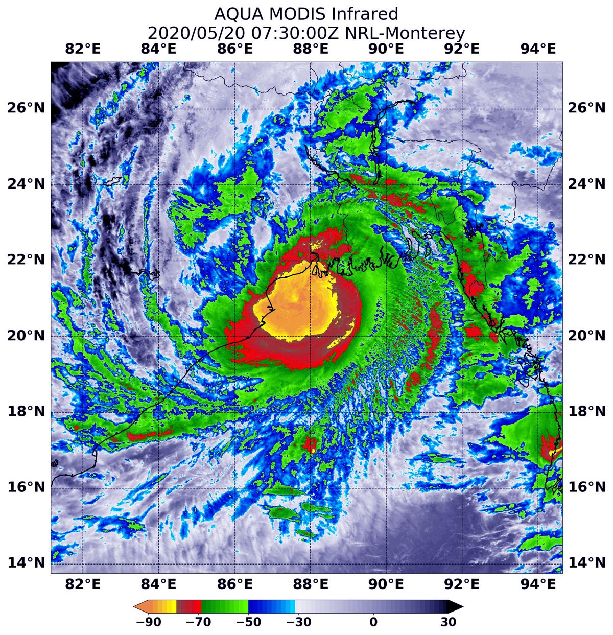
An instrument on NASA's Aqua satellite took a natural-color image of the storm covering the region as winds reached a category 2 scale, with speeds of 105 miles (165 kilometers) per hour. The Moderate Resolution Imaging Spectroradiometer (MODIS) showed the storm as it delivered a dangerous surge to coastal regions.
"Winds decreased as Amphan moved north-northeast over land, but the storm remained powerful enough to destroy buildings, uproot trees and crops, and down powerlines," NASA's Earth Observatory said in an accompanying statement.
Related: NASA's Earth observing system: Monitoring the planet's climate
"The winds pushed up a 5-meter (16-foot) storm surge that flooded coastal areas, including the Sundarbans, an area of mangrove forests and critical tiger habitat in the delta spanning the India-Bangladesh border," NASA officials said in the statement.
MODIS has also provided infrared imagery showing cloud top temperatures of the tropical storm. The advantage of infrared data is, in a tropical storm that can span thousands of miles, the data shows where the strongest regional thunderstorms are located.
The strongest thunderstorms, NASA added, have the coldest cloud top temperatures because these storms push high into the troposphere, or region of Earth's atmosphere that is closest to the planet's surface.
Get the Space.com Newsletter
Breaking space news, the latest updates on rocket launches, skywatching events and more!
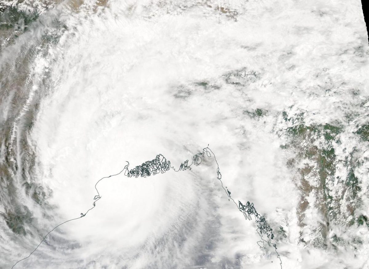
The Suomi National Polar-orbiting Partnership (NPP) satellite, which is administered by NASA and NOAA, showed visible light imagery of Amphan on Tuesday (May 19), when the storm covered the northern part of the Bay of Bengal. The bay is in the northeastern part of the Indian Ocean, surrounded by India to the west, Bangladesh to the north, and Myanmar to the east.
"Tropical cyclones and hurricanes are the most powerful weather events on Earth," NASA said in a separate statement. "NASA researches these storms to determine how they rapidly intensify, develop and behave. NASA's expertise in space and scientific exploration contributes to essential services provided to the American people by other federal agencies, such as hurricane weather forecasting," the statement added.
- Hurricanes, typhoons and cyclones: Storms of many names
- What's the difference between a typhoon and a super-typhoon?
- NASA peers into the eye of a 'super typhoon' (photo)
Follow Elizabeth Howell on Twitter @howellspace. Follow us on Twitter @Spacedotcom and on Facebook.
OFFER: Save 45% on 'All About Space' 'How it Works' and 'All About History'!
For a limited time, you can take out a digital subscription to any of our best-selling science magazines for just $2.38 per month, or 45% off the standard price for the first three months.
Join our Space Forums to keep talking space on the latest missions, night sky and more! And if you have a news tip, correction or comment, let us know at: community@space.com.

Elizabeth Howell (she/her), Ph.D., was a staff writer in the spaceflight channel between 2022 and 2024 specializing in Canadian space news. She was contributing writer for Space.com for 10 years from 2012 to 2024. Elizabeth's reporting includes multiple exclusives with the White House, leading world coverage about a lost-and-found space tomato on the International Space Station, witnessing five human spaceflight launches on two continents, flying parabolic, working inside a spacesuit, and participating in a simulated Mars mission. Her latest book, "Why Am I Taller?" (ECW Press, 2022) is co-written with astronaut Dave Williams.

