Satellite images show epic snowstorm that shut down part of Interstate 95
The nor'easter sent more than 14 inches of snow into the Mid-Atlantic region of the U.S.

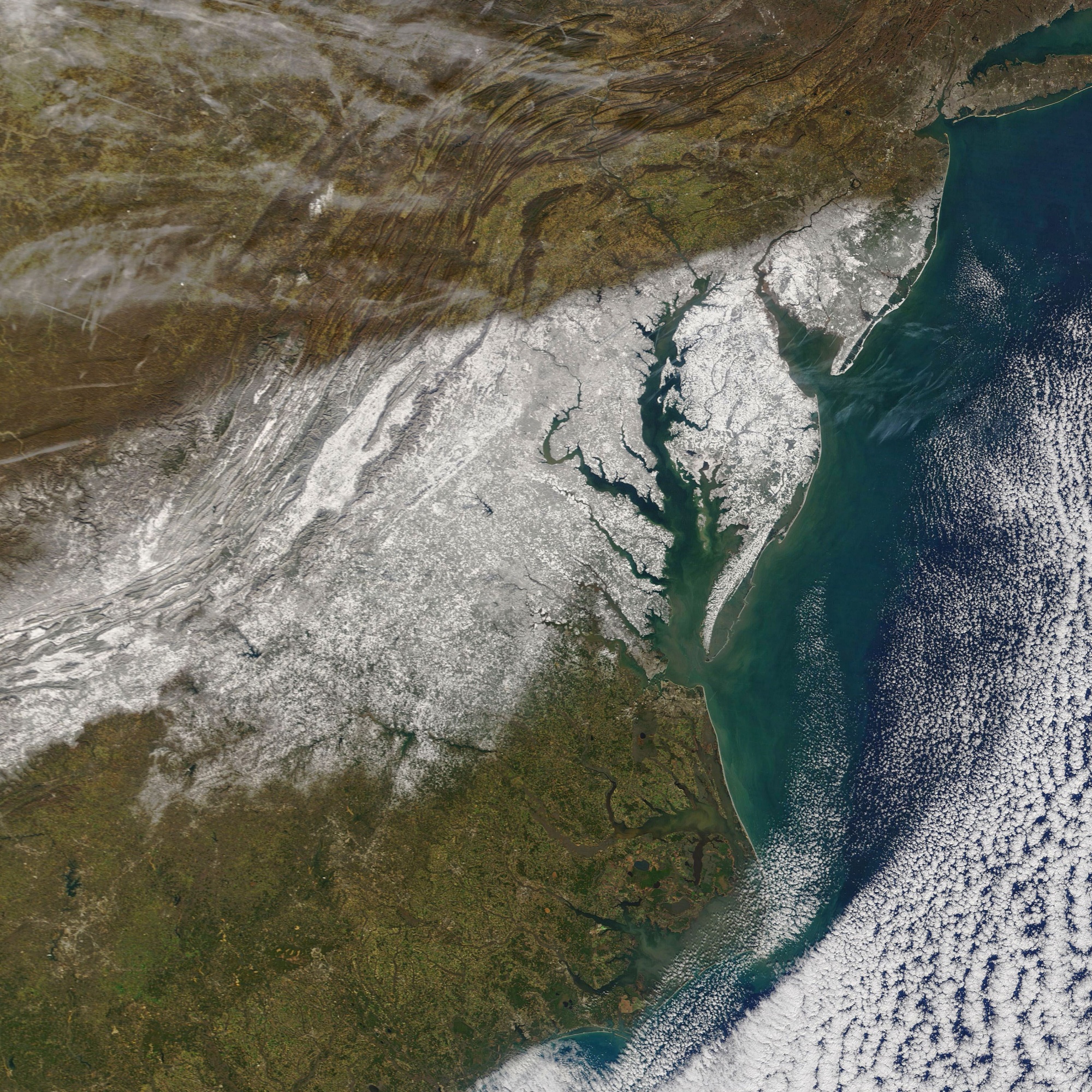
A band of snow blankets the United States northeast in a new satellite photo showing the huge storm stranding motorists on Interstate 95 in Virginia.
The Moderate Resolution Imaging Spectroradiometer (MODIS) instrument on NASA’s Terra satellite captured the storm, which dumped more than 14 inches (36 centimeters) of snow on parts of southern Virginia and southern Maryland.
Motorists were stuck up to 24 hours on Virginia's Interstate 95, one of the busiest stretches of the highway in the country, as jackknifed tractor-trailers and other accidents caused a large backup of traffic over dozens of miles.
"It's been so horrible," Arlin Tellez, 22, told The New York Times. Tellez was stranded in her car from 5 p.m. local time Monday (Jan. 3) overnight through Tuesday (Jan. 4) with no food or water and only a few sets of clothes in the car.
Related: Hubble telescope sees a space 'snowman' thousands of light-years away
Yesterday, the #NOAA20 satellite's VIIRS instrument captured the snowy aftermath from Monday's winter storm across Delaware, Maryland, and Virginia. ❄️ pic.twitter.com/CV3744gh4FJanuary 5, 2022
"There's just no way for us to know what's actually happening," Tellez added. "When we tried to call the police, because at this point that was our only resource, they literally just told us to hang on tight."
Virginia State Police told the Times that no serious injuries or fatalities arose among the stranded motorists, who were freed by Tuesday evening local time. The storm overall has produced at least five reported deaths.
Get the Space.com Newsletter
Breaking space news, the latest updates on rocket launches, skywatching events and more!
The storm was termed a nor'easter, a type of storm present in the northeastern United States with attributes such as "precipitation in the form of heavy rain or snow, as well as winds of gale force, rough seas, and, occasionally, coastal flooding," the National Oceanic and Atmospheric Administration's National Weather Service says on its website.
The fierce storms arise when the polar jet stream collides with warm air from the Gulf of Mexico. "This difference in temperature between the warm air over the water and cold Arctic air over the land is the fuel that feeds nor'easters," NOAA's website adds.
Follow Elizabeth Howell on Twitter @howellspace. Follow us on Twitter @Spacedotcom and on Facebook.
Join our Space Forums to keep talking space on the latest missions, night sky and more! And if you have a news tip, correction or comment, let us know at: community@space.com.

Elizabeth Howell (she/her), Ph.D., was a staff writer in the spaceflight channel between 2022 and 2024 specializing in Canadian space news. She was contributing writer for Space.com for 10 years from 2012 to 2024. Elizabeth's reporting includes multiple exclusives with the White House, leading world coverage about a lost-and-found space tomato on the International Space Station, witnessing five human spaceflight launches on two continents, flying parabolic, working inside a spacesuit, and participating in a simulated Mars mission. Her latest book, "Why Am I Taller?" (ECW Press, 2022) is co-written with astronaut Dave Williams.


