Wildfires in Greece have burned land twice the size of Manhattan, satellite images reveal
Greece's worst wildfire this year came after the country's hottest summer on record.
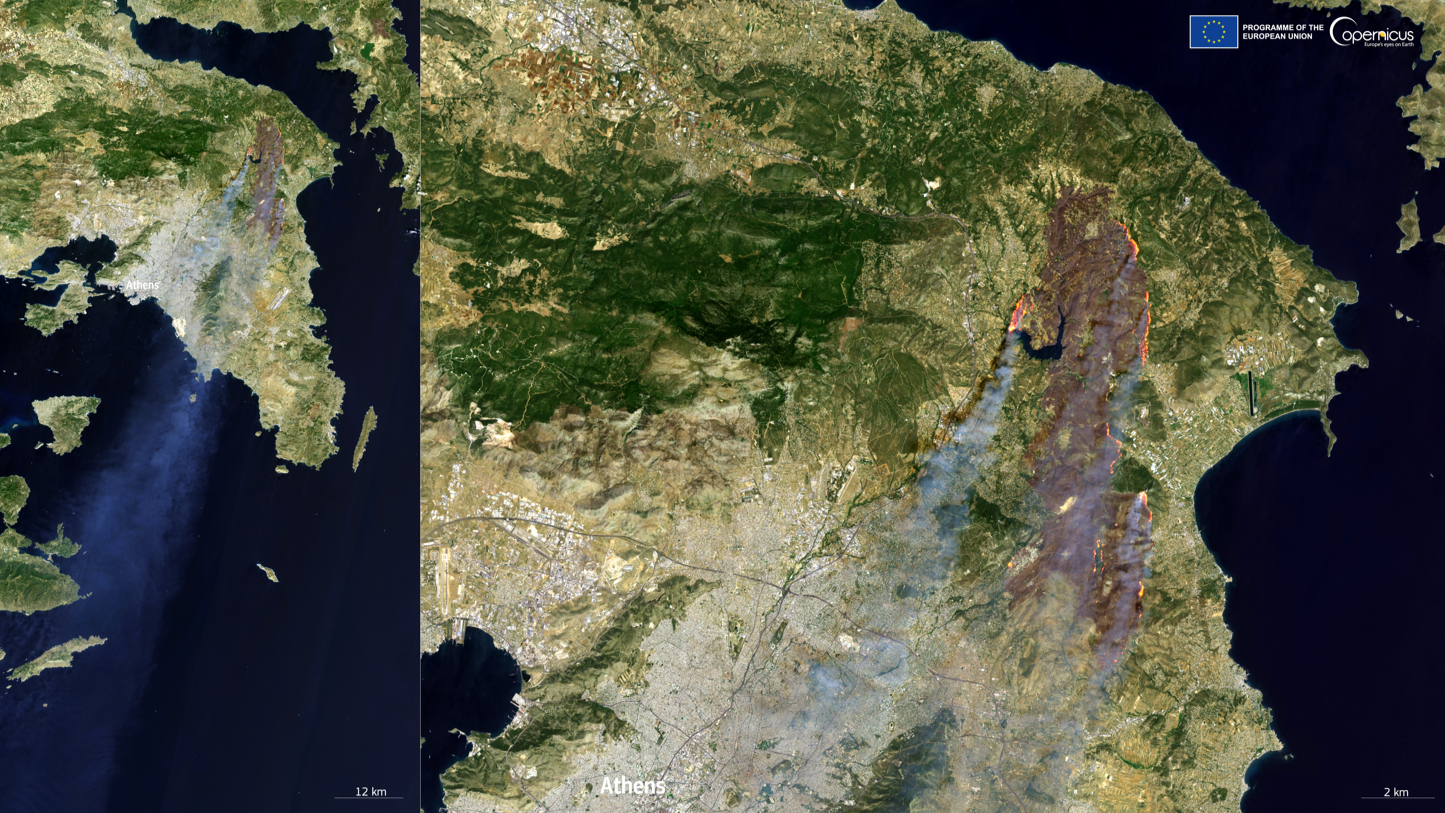
A large wildfire has scorched 25,000 acres of land — twice the size of Manhattan — on the fringes of Athens, the capital of and largest city in Greece, according to European satellite images shared on Wednesday (Aug. 14).
The Copernicus Emergency Management Service (EMS) posted an image to X (formerly Twitter) showing the extent of the damage a day after hundreds of firefighters succeeded in containing what had become Greece's worst wildfire this year.
The fire first erupted on Sunday (Aug. 11) afternoon in Varnavas, a small town roughly 22 miles (35 kilometers) northeast of Athens. Fanned by strong winds and exacerbated by Greece's hottest and driest summers on record, the fire broke out into several fronts, killing at least one person and injuring dozens, including firefighters, Greek authorities said.
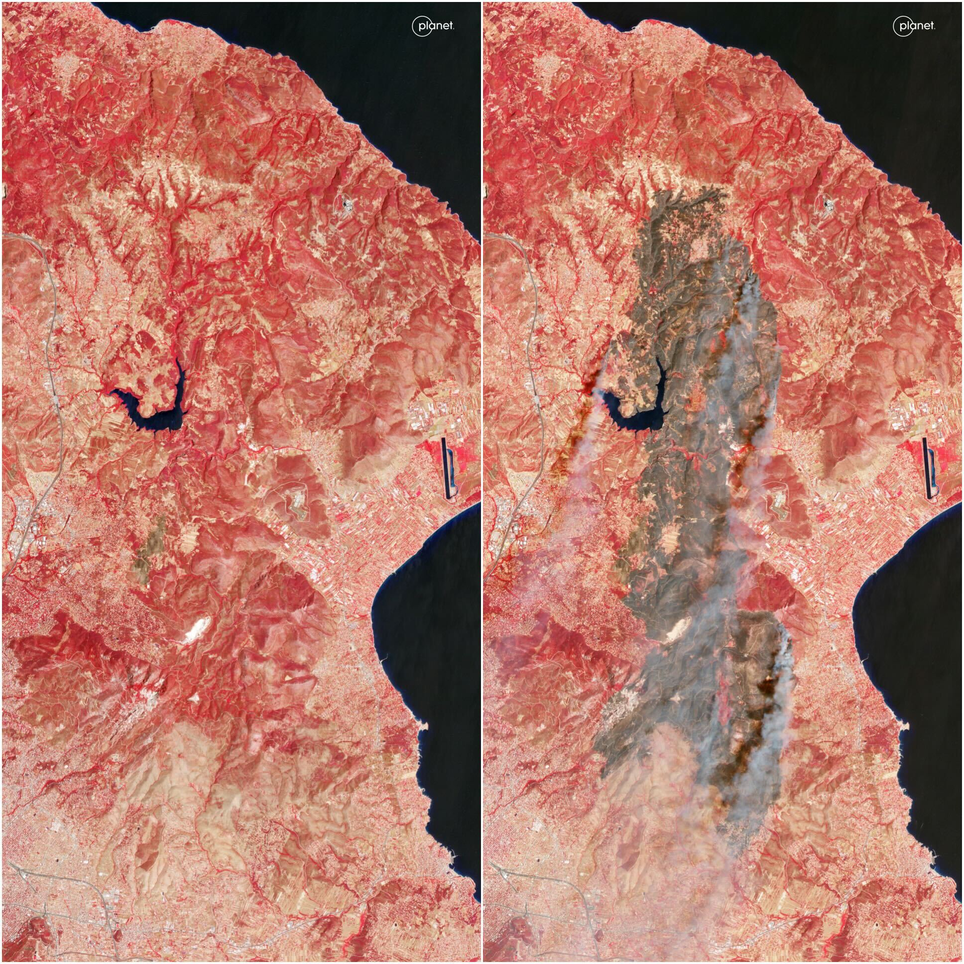
Greek authorities requested that The Copernicus EMS — an Earth observation program that captures satellite imagery for emergency response during disasters — provide an initial estimate of the fire's extent and conduct an assessment of the damage. Images from the Sentinel-2 satellite captured on Monday (Aug. 12) showed a total of 168 active flames, including some just a few miles from the center of Athens, where 3 million people reside. Although Greece witnesses fires annually, none have come this close to the Greek capital, according to CNN.
Related: Extreme wildfires are on the rise globally, powered by the climate crisis
#EMSR746As the #wildfire north of #Athens 🇬🇷 continues to rage, the 🇪🇺 is working together to respondOur #MappingTeam has delivered its Delineation Product, which, as of 12 August, has detected:🔸+8,500 hectares of burnt area🔸23 km of fire fronts🔸168 active flames pic.twitter.com/zb8SUFDUoXAugust 13, 2024
A NOAA satellite captured smoke blowing from bright orange fires when it passed over the region, also on Monday. Extending over 180 miles (300 kilometers), the smoke cloud can be seen spreading southwest toward Libya in North Africa.
As it passed over the region yesterday, the #NOAA20 satellite captured the #smoke plumes and heat signatures from large #wildfires burning near Athens, Greece. #GreeceFires pic.twitter.com/o6mq0hYMFKAugust 13, 2024
As spells of dry weather linked to human-driven climate change bake southern Europe in back-to-back heatwaves, fierce wildfires have also broken out in Spain and elsewhere in the Balkans.
Get the Space.com Newsletter
Breaking space news, the latest updates on rocket launches, skywatching events and more!
In Greece, much of the wildfire smoke had dissipated by Tuesday, BBC reported, leaving behind hazy skies hanging over Athens. But the risk of flare ups from scattered hotspots linger over the region this week due to wind gusts and high daytime temperatures.
Join our Space Forums to keep talking space on the latest missions, night sky and more! And if you have a news tip, correction or comment, let us know at: community@space.com.

Sharmila Kuthunur is a Seattle-based science journalist focusing on astronomy and space exploration. Her work has also appeared in Scientific American, Astronomy and Live Science, among other publications. She has earned a master's degree in journalism from Northeastern University in Boston. Follow her on BlueSky @skuthunur.bsky.social

